
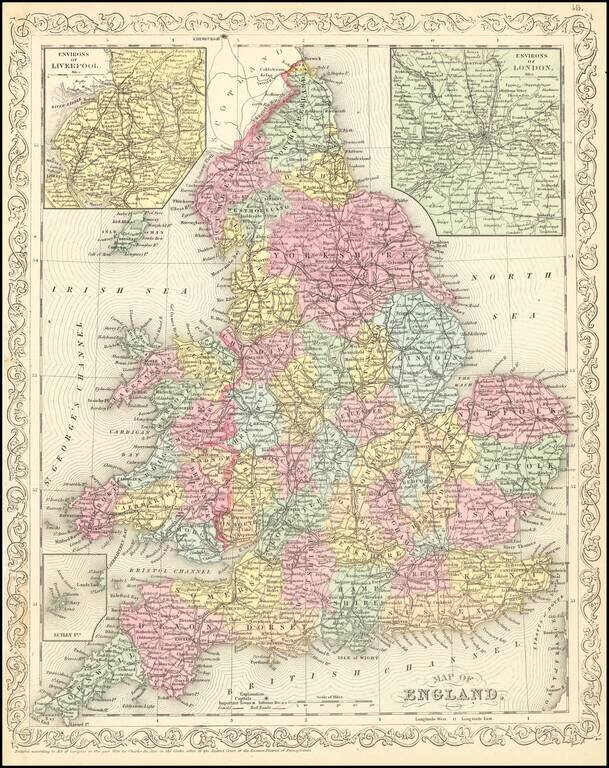
Scarce Charles Desilver map of England, published in 1857. The map is hand colored by county and shows towns, rivers, bays, lakes, railroads, roads, etc.
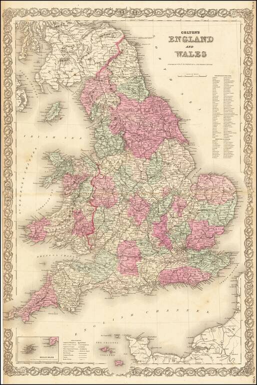
Nice large format map of England & Wales, hand colored by counties.
![A Chart of the Aintree Race Course [Liverpool, England]](/map/small/70234.jpg)
Rare pictorial map of the famed Aintree Race Course, home to the Grand National, drawn by pictorial artist George Annand, The two mile course boasts 30 fences, individually numbered, the race consists of two laps. Ditches and water features provide...
![[Two Sheet Detailed Agricultural Map] Great Britain](/map/small/68080.jpg)
A fascinating map of Great Britain compiled by the Ministry of Agriculture and Fisheries in June 1939 and printed by the Ordnance Survey in 1944. The map shows the types of agriculture which dominate in each region of the United Kingdom. Approximately...
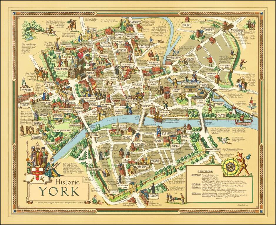
Finely executed pictorial map of the City of York, published in York by by Ben Johnson & Co. The map is the work of York's own commercial illustrator Estra Clark. The map shows buildings, landmarks, sites of significant events, the city wall,...
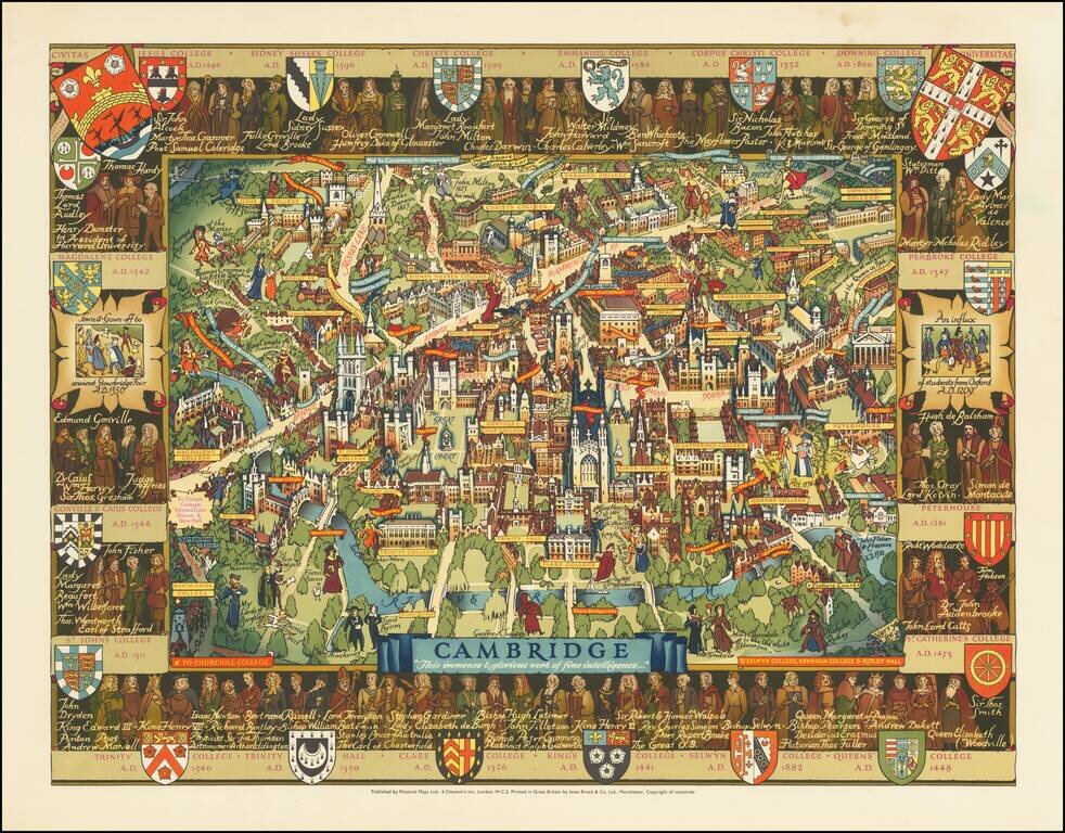
An attractive pictorial map of the idyllic and historical university town of Cambridge. The twenty-one constituent colleges of the university are all listed and shown around the map, save for Selwyn, Newnham, and Girton. The city is portrayed in...
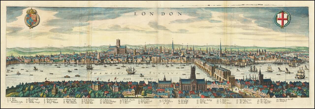
An Early Birdseye View of London A striking panoramic view of the London before the fire, with a key noting 43 places within the City. The view extends from the King's Palace at Whitehall to the Tower of London and St. Katherine's Church in the east....
![(London) Ch.de Withal [Whitehall]](/map/small/16809.jpg)
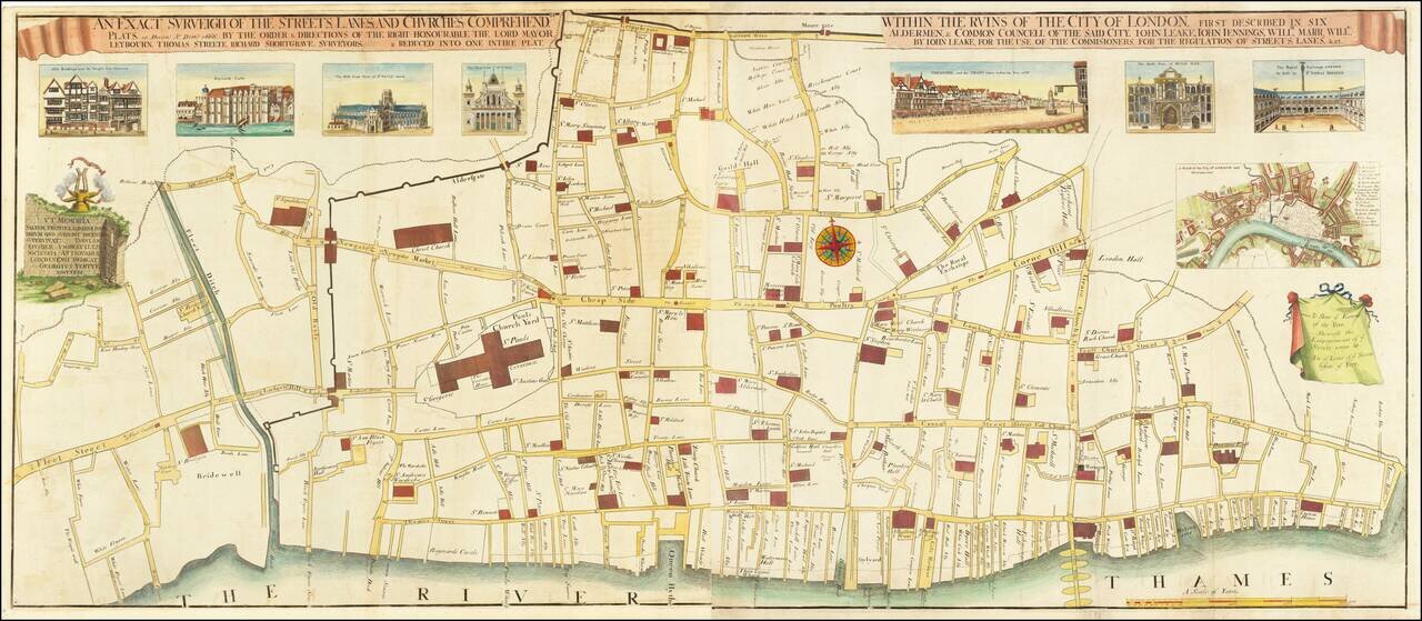
George Vertue's Edition of a London Rarity Nice example of George Vertue's magnificent engraving on two sheets of the destruction in London after the Great Fire of 1666. The map extends from Fetter Lane to Tower Dock, focusing on the damage caused by...
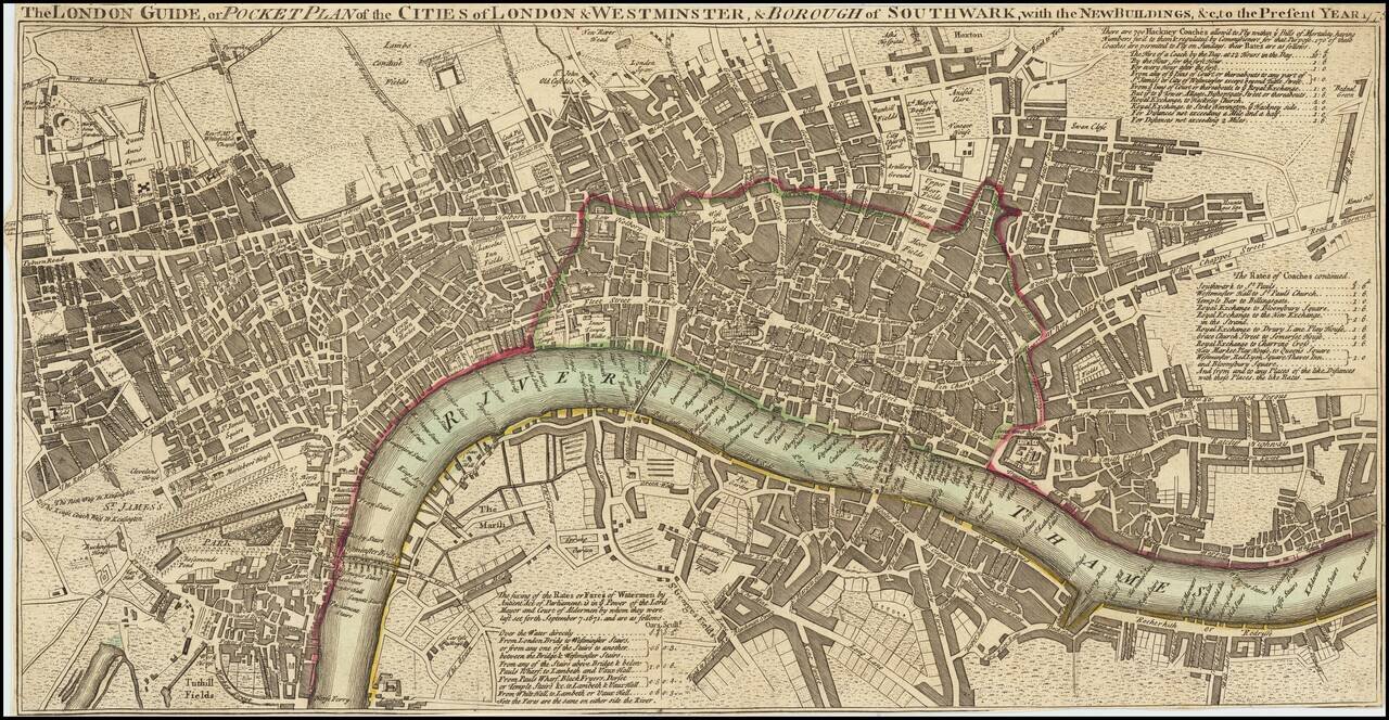
![[New and Exact Plan of the City’s of London and Westminster and the Borough of Southwark And the Additional New Buildings Churches &c to the present Year 1735.] (Western sheet]](/map/small/62521.jpg)
Detailed map of the western half of London, published by Thomas Jefferys in 1735. The map is the western half of Jefferys New and Exact Plan of the City’s of London and Westminster and the Borough of Southwark And the Additional New Buildings...
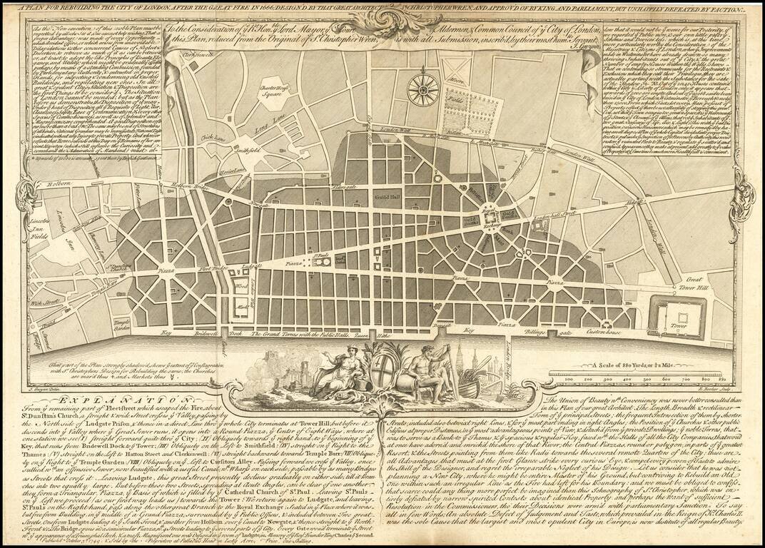
One of the Rarest of Christopher Wren's Proposed Plans for Rebuilding London. Fine reduced example of Christopher Wren's plan for rebuilding London after the fire, by John Gwynn, engraved by Edward Rooker and published by the Proprietors at Palladios...
![[London] Redriffe and Part of St. Mary Magdalens Parish Southwark Taken from ye Latest Survey with Corrections](/map/small/70290.jpg)
Decorative map of the Rotherhithe and Bermondsey sections of what is now greater London. Fine example of this map of a portion of London, from John Strype's re-issue of John Stow's Survey of London, originally, was published in 1598. Strype expanded...
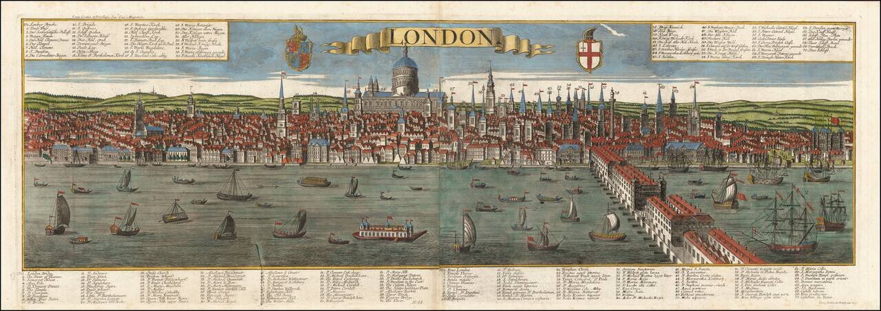
Striking panoramic view of London, published in Augsburg by the Probst family. Highly detailed 18th century post-fire panorama of London as seen from the south bank of the Thames River, looking toward the St. Paul’s Cathedral, engraved by Friedrich...
![Plan of Baynards Castle Ward & Faringdon Ward, Within. Divided into Parishes, from a New Survey [with] Plan of Candlewick and Langborn Wards. Divided into Parishes, from a New Survey](/map/small/70263.jpg)
Interesting pair of ward maps of London, published in 1760. Landmark locations include St. Paul's Cathedral and Blackfriar's Bridge.
Unrecorded? 1775 Edition of This Map of London. Antique engraved map of in the late-18th century, published by Carrington Bowles in 1775. The map includes great detail of streets and built-up sections of the city; most streets and squares are named....
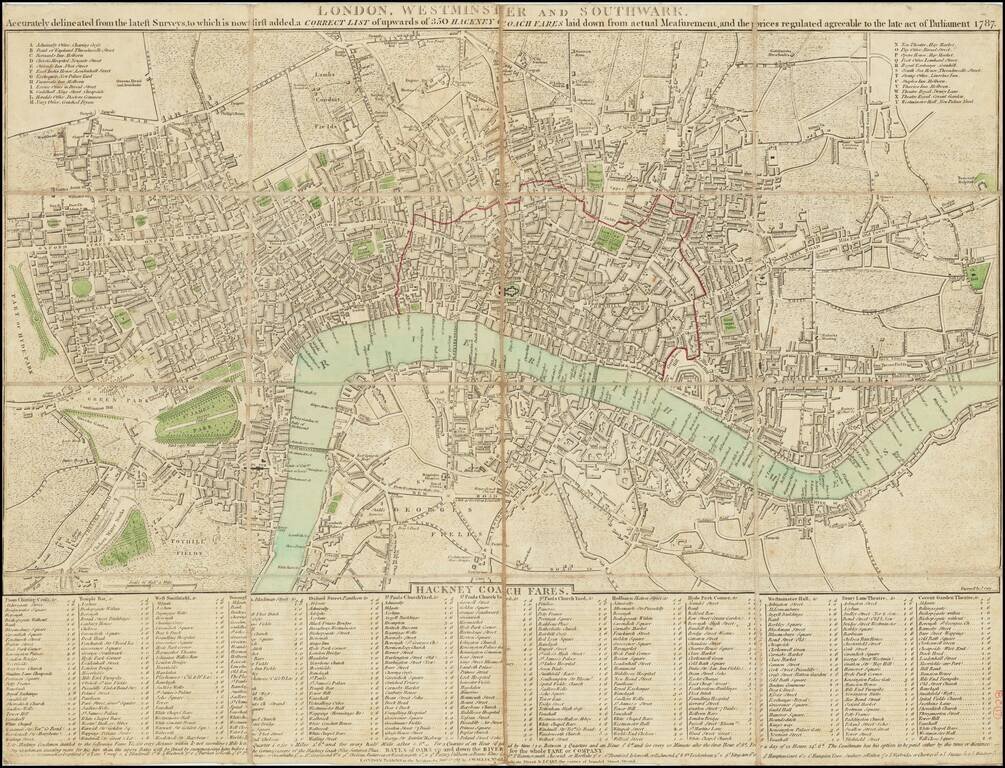
Detailed early plan of London, published in 1787. The map extends from Islington to Newington Butts and from east to west from Stepney to Hyde Park. Includes a list of important buildings with references at the top left and right and an extensive...