
![Patriarchatus Antiocheni Geographica Descriptio . . . [shows Cyprus]](/map/small/54177.jpg)
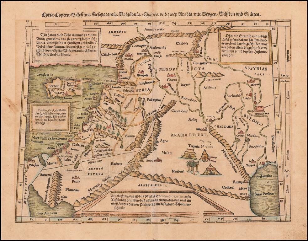
The Cradle of Civilization Rare and highly decorative map of the region bounded by Cyprus and the Holy Land in the west and Sinus Persicus and Susiana in the east. Toward the center is the confluence of the Tigris and Euphrates rivers.
![[Eastern Mediterranean]](/map/small/61501sb.jpg)
Only known example of the rare map of of the Eastern Mediterranean. As note by Bifolco, this unique map is one of four sheets from a 16th century wall map of Europe, which an incomplete example survives the Civic Library of Bergamo in Italy (3 of 4...
![Cyprus Insula [with] Candia, Olim Creta](/map/small/65746.jpg)
Striking example of Ortelius' first map of Cyprus and Crete, from Ortelius' Theatrum Orbis Terrarum, the first modern atlas of the World. The map is based upon earlier maps by Bordone (1528) and Camocio (1564). During the time of the map's creation,...
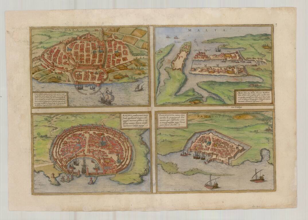
Nice old color example of Braun & Hogenberg's views of Famagusta, Rhodes, Malta and Cagliari. From Braun & Hogenberg's Civitatus Orbis Terrarum, the most important book of town plans and views published in the 16th Century.
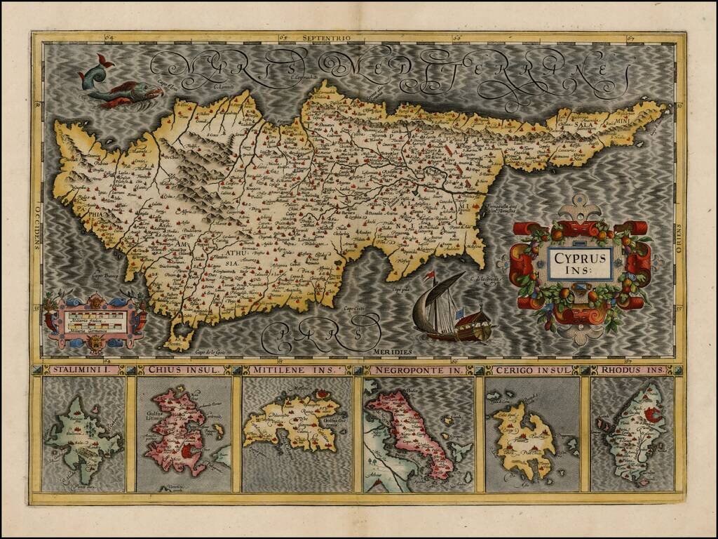
Striking early map of Cyprus, with 6 smaller maps below, showing Stalimini, Chius, Mitilene, Negroponte, Cerigo and Rhodus Islands. A fine example of Mercator's work, with the classic engraving of the sea characteristic of his work. Nice example.
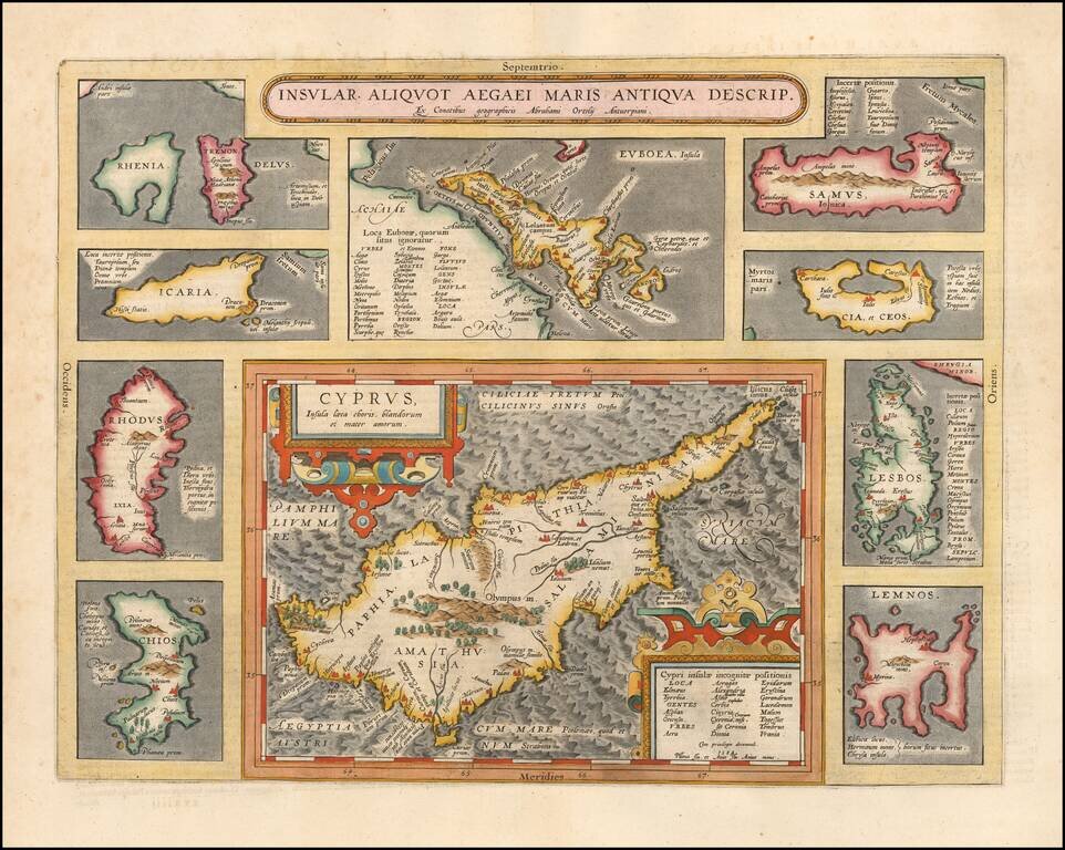
Striking full color example of Ortelius' map of Cyprus, ringed by smaller maps of islands in the Aegean, including Lesbos, Rhodes, Rhenia, Tremon, Icaria, Euboaea, Chios, Lemnos, Cia et Ceos and Samus. From Abraham Ortelius' Theatrum Orbis Terrarum,...
![Asia Minor [Shows Cyprus]](/map/small/43185.jpg)
Very rare map of Cyprus and Asia Minor by Phillipe de la Rue. While we were able to locate examples of the map issued by Covens & Mortier in the 18th Century, this map appears to be very rare.
![Turkey in Asia [Shows Cyprus]](/map/small/67948.jpg)
Detailed map of Asia Minor, Cyprus, Syria, Armenia, Al-Jesira, Irak, Kurdistan and Azerbijan. Shows towns, islands, rivers, mountains, gulfs, bays, etc. Includes Cyprus and a large insets of the Environs of Constantinople. Nice ethnic detail, with...
![Quarta Asiae Tabula [Shows Cyprus]](/map/small/64078.jpg)
Fine Old Color example of Martin Waldseemüller's edition of Ptolemy's map of the Holy Land, the Levant and Mesopotamia, printed in Strasbourg in 1513. This remarkably beautiful map is one of the most historically important and finely printed early...
![[Untited Modern Map of Cyprus, Syria, Palestine, etc.]](/map/small/55764.jpg)
One of the earliest obtainable modern maps of Cyprus, Syria, the Holy Land, and contiguous regions, from the 1525 edition of Fries edition of Ptolemy's Geographia. Fries map of Cyprus, Syria, Mesopotamia, Babylonia, Arabia Petraea, Armenia Minor and...
Colored example of Munster's map of Cyprus, Syria, the Holy Land and contiguous regions, from an early edition of Munster's Cosmographia. Munster's Cosmographia was one of the most influential geographical works of the 16th Century and had a profound...
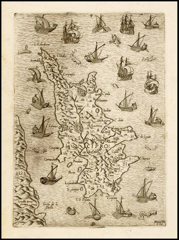
Rare separately issued map of Cyprus, published in Venice in 1570 by the Venetian mapmaker, Nicolo Nelli. The map shows Cyprus at the beginning of the Turkish attack of 1570, surrounded by Venetian ships. Historical Context: The Popular Fascination...
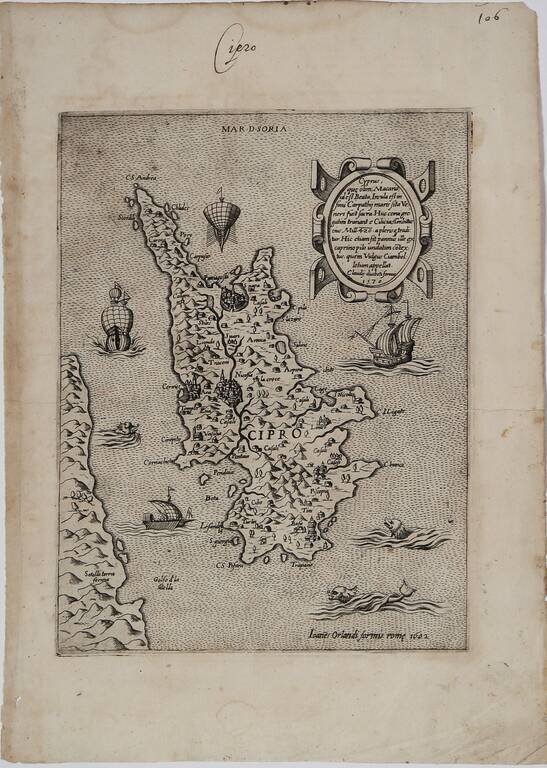
Rare Early Map of Cyprus By Paolo Forlani Second state of this rare early map of Cyprus, published in Venice by Paolo Forlani. The map is oriented with the east at the top and includes a nice descriptive cartouche at the top right. From the...
![Tab. IV. Asiae in qua Mesopotamia, Syria, Arabia Petrea ac Deserta . . . [Shows Cyprus]](/map/small/58766.jpg)
Nice wide margined example of Mercator's Ptolemaic map of Cyprus, the Holy Land, Syria, Chaldea, Mesopotamia, Armenia, etc. Nice example of Mercator's map of the region, from Mercator's edition of Ptolemy's Geographia, first published in 1578 and...
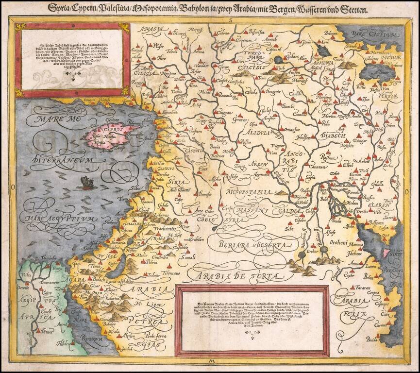
Finely colored map of Cyprus, Syria, the Holy Land and contiguous regions, from an early edition of Munster's Cosmographia. Munster's Cosmographia was one of the most influential geographical works of the 16th Century and had a profound impact on the...
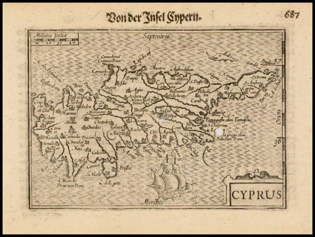
Nice example of this early state of Barent Langenes's map of the Island of Cyprus, which first appeared in the 1598 edition of Langenes's Caert-Thresoor, published in Middelburg. Langenes's map was first issued in his Caert-Thresoor and later...