
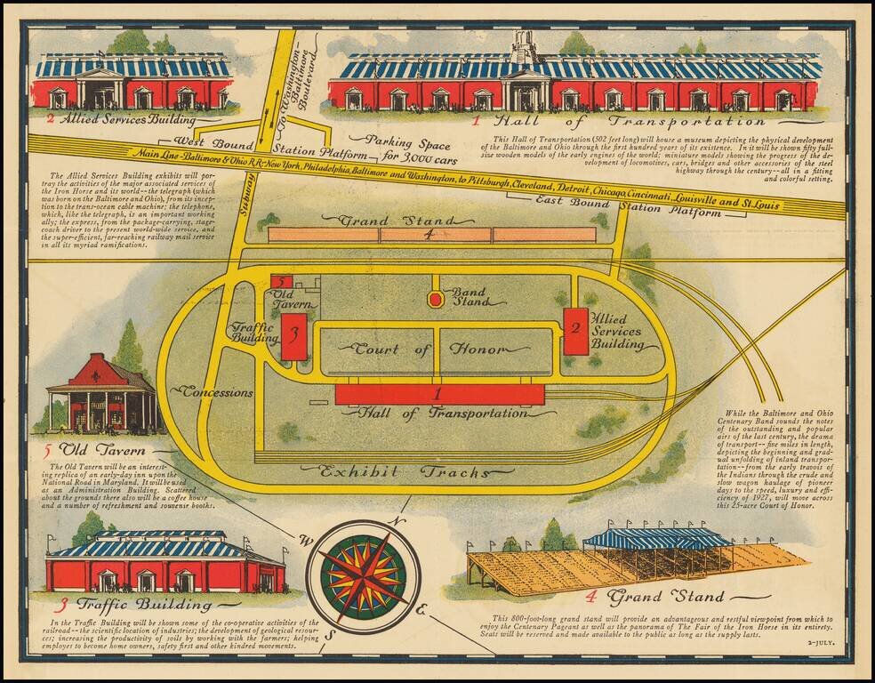
Celebrating 100 Years of the Baltimore & Ohio Railroad Interesting chromolithographic plan of the Fairgrounds for the Fair of the Iron Horse. The map is centered on the Court of Honor and illustrates the exhibition's major buildings.

A Rare British Sea Chart of the Southeast and Mid-Atlantic Regions (The Colonial Williamsburg / William Wooldridge Copy) Extremely rare separately issued chart of the coast from New York to North Carolina, which was issued separately and in Laurie...
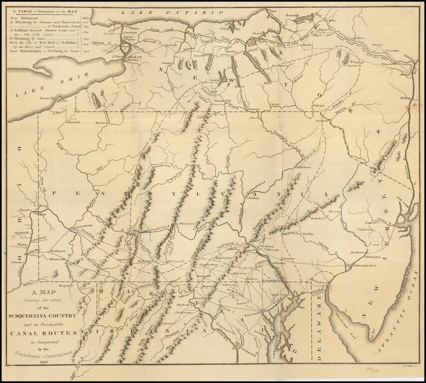
Fine large folding map, illustrating the work of the Commissioners appointed in December 1822 to survey the route of a Canal which would connect the Susquehanna River with the City of Baltimore. Published by Fielding Lucas Jr. in Baltimore, this rare...

Christopher Browne's Map of the Chesapeake & Delaware Bay Regions -- The First Map to Accurately Depict The Boundary Line Which Settled The Penn-Calvert Boundary Dispute, Which Would Become The Mason-Dixon Line Rare second state of Christopher...
![Carte Particuliere de Virginie, Maryland, Pennsilvanie, La Nouvelle Jarsey. Orient et Occidentale [Heighten in Gold!]](/map/small/61392mp2.jpg)
Heightened with Gold Leaf -- Fine Old Color Fine early large-format chart of Chesapeake Bay and the Delaware Estuary, by Pierre Mortier. This detailed and attractive chart focuses on Chesapeake Bay, and includes all of the Tidewater areas of...

John Senex's edition of the Augustine Hermann Map of the Chesapeake. An antique map of the Chesapeake Bay from John Senex's edition of Christopher Browne's seminal map. Includes the Delaware Bay, Maryland and parts of Pennsylvania and New Jersey,...

Detailed map of Maryland, Delaware, the Chesapeake Bay and parts of New Jersey and Pennsylvania. Engraved by Thomas Kitchin. The map shows towns, counties, roads, rivers, bays, and a host of other details. The map accompanied the August 1757 edition...

The Survey of the Mason Dixon Line. Detailed regional map of the Chesapeake and contiguous parts of Maryland, Virginia, Delaware, New Jersey and Pennsylvania, showing the results of Mason & Dixon's survey of the boundaries between Pennsylvania...
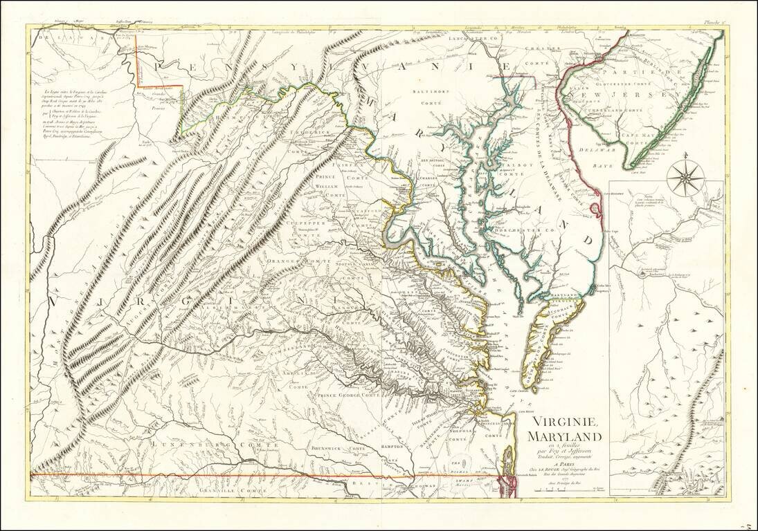
Rare Revolutionary War period map of Virginia & Maryland, published by Le Rouge. Le Rouge's 2 sheet edition is based upon the Fry Jefferson map, but covers only Virginia, Maryland & Delaware, plus the southern portions of New Jersey and...

A Legendary American Rarity: The First State of the Churchman Map of the Chesapeake, One of the Only Maps Published in America During the Revolution. Rare, separately-issued American map of the Delmarva Peninsula, Chesapeake Bay, and Delaware Bay,...
![Observations sur la Virginie [with the map:] A Map of the country between Albermarle Sound, and Lake Erie, comprehending the whole of Virginia, Maryland, Delaware, and Pensylvania, with parts of several other of the United States of America. Engraved for](/map/small/51828.jpg)
First Published Edition of Jefferson's Notes on Virginia, with the Only Map Attributed to Thomas Jefferson. Engraved folding map, folding table. [4], viii, 190, [6], 197-387, 288-290, [5, errata] pages of French text (i.e., complete). 8vo, 8 x 4.75...
![Notes on the State of Virginia [with the map:] A Map of the country between Albemarle Sound, and Lake Erie, comprehending the whole of Virginia, Maryland, Delaware, and Pensylvania, with parts of several other of the United States of America. Engraved for](/map/small/55181.jpg)
Engraved folding map, folding table. Title, advertisement and contents leaf, 382 pages of English text (i.e., complete). 8vo, 8 x 4.75 inches, contemporary calf, rebacked to style. First English Edition of Jefferson's Notes on Virginia, with the Only...

Thomas Jefferson's Map of Virginia Thomas Jefferson's rare and important map of the Mid Atlantic region, engraved from a manuscript draft drawn by Jefferson in 1786, while serving as a United States Minister in Paris. The map was prepared to...
The First Large Format Sea Chart of the Chesapeake Published in America Fine large chart of the coastline from New Jersey south to Cape Henry, Virginia, published by William Norman in Boston. The chart includes a detailed treatment of the Chesapeake...
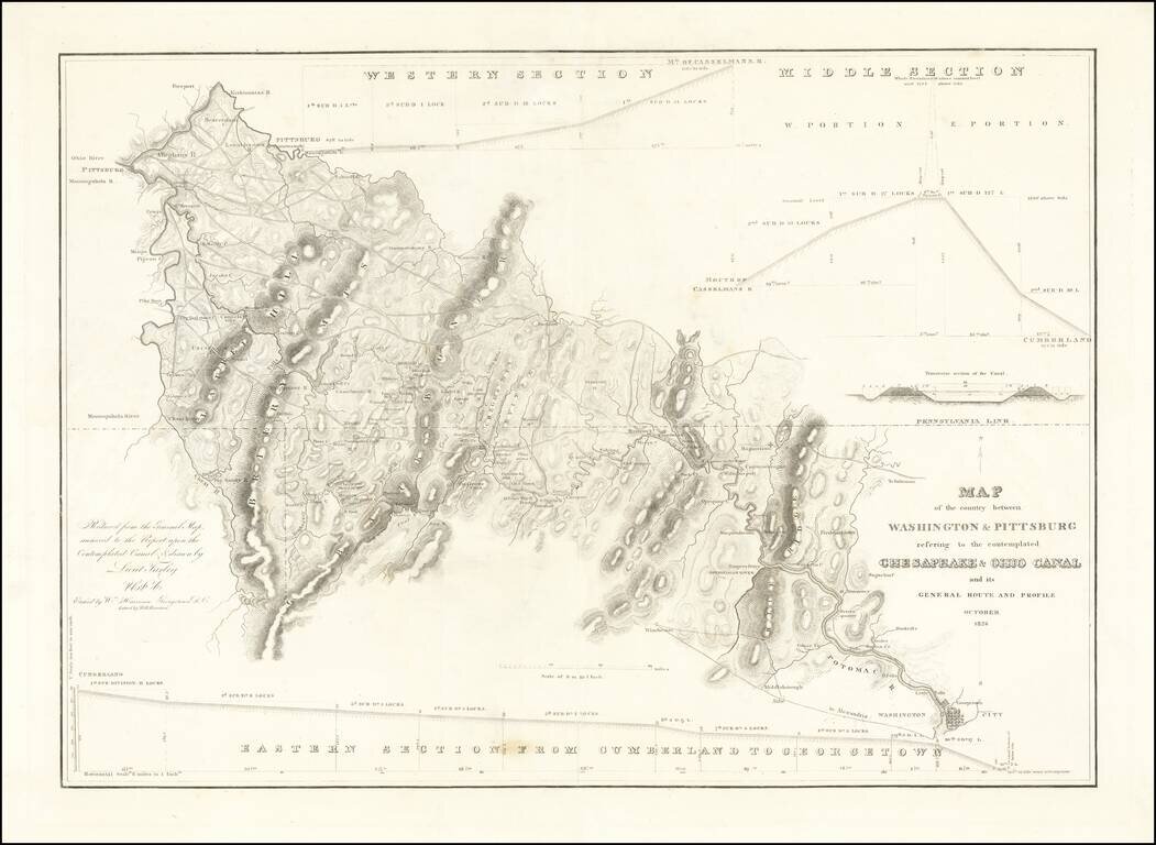
Rare separately issued map showing the route of the proposed Chesapeake and Ohio Canal, likely published as a presentation piece. After the Revolutionary War, George Washington was the chief advocate of using waterways to connect the Eastern Seaboard...
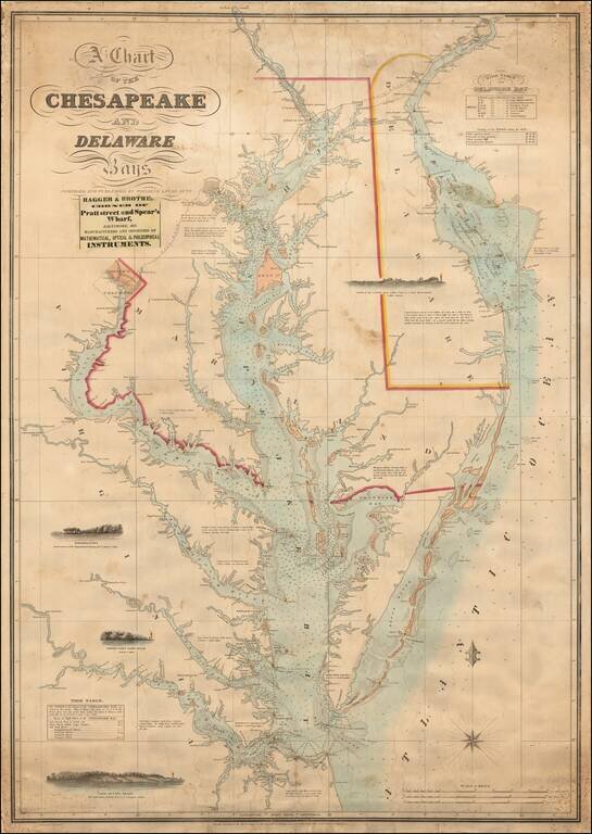
The Most Important Sea Chart of the Chesapeake Published In the 19th Century Scarce and highly desirable chart of the Chesapeake and Delaware Rivers by Fielding Lucas. One of the most decorative and sought after 19th Century charts of the Chesapeake,...