
![[Signed Political Satire Artwork] Vietnam ... Vietnam ... Vietnam ...](/map/small/68726.jpg)
Signed Artwork By Famed Political Cartoonist Bob Gorrell Original cartoon artwork on paper by world renowned political cartoonist Bob Gorrell. Original cartoon was drawn for the Richmond News Leader in 1983, showing Uncle Sam being shown various...

One of the Earliest Modern Maps of Russia Striking map of Russia, based upon Anthony Jenkinson's rare map of Russia drawn in 1562. The map covers the region from the Gulf of Finland, Lithuania and the Black Sea to the Sur River, Tashkent, the...

Decorative map of the Black Sea Region, with a large decorative cartouche surmounted by the Russian Imperial Coat of Arms. The map extends north to Moscow and Smolensk from Constantinople in the south.

This is a scarce map encompassing Poland and parts of the grater Baltic Region, Russian, and Ukraine. The map extends from the Gulf of Riga to the Black Sea at the mouth of the Dniepr. The map includes an attractive cartouche. This is only the second...
![Europe No. 16. Partie De La Russie D'Europe [Tambow, Woroniege, Saratow and Territoire De La Milice De Don, etc.]](/map/small/19823.jpg)
Regional map of part of Russia and the Ukraine. Shows towns, roads, rivers, mountains, and a host of other details. From Vandermaelen's remarkable 6 volume atlas, which if combined as globe gores forms an immense globe.

![Сны Султана (Картина 2) [Dreams of the Sultan. Scene 2]](/map/small/60238.jpg)
Russia Imagines the Ottoman Response to Crimean War Reversals. A fascinating ephemeral lithograph, this was apparently one of three "scenes" prepared during the Crimean War, and said to represent the Ottoman ruler's response to defeats during the...
![Повстанцы 1863 Года [(Polish) Insurgents of 1863]](/map/small/52719.jpg)
Three Vilnius-Published Prints of the January Uprising -- Polish National Uprising in 1863. A highly unusual, early Lubki (popular graphic) series, locally-published in Vilnius, Lithuania and depicting a contemporary nationalist revolt by the...
![[Soviet Russian Ecology Propaganda Poster] Основы Водного Законодательства Союза ССР](/map/small/68343.jpg)
Original vintage Soviet Russian propaganda poster. The title translates as follows: The blue expanse is dear to us everywhere and it is not without reason that we are talking about it. - It's time to protect the wealth of our rivers and lakes in...

Willem Barentsz's Map of the Polar Regions, drawn from his observations during his third voyage of 1596-97 and engraved by Baptiste Van Deutecum. The Barentsz map of the polar regions is a major landmark in Arctic cartography, depicting the details...

Willem Barentsz's Map of the Polar Regions, drawn from his observations during his third voyage of 1596-97 and engraved by Baptiste Van Deutecum. The Barentsz map of the polar regions is a major landmark in Arctic cartography, depicting the details...
![[Spitzbergen & Wiches Lande]](/map/small/61990.jpg)
Mapping the early whaling voyages of the Muscovy Company Scarce early map of Spitzbergen, flanked by nine scenes of whaling, fishing, processing & bear hunting, and walruses (here called Seamorces), which first appeared in Purchas His Pilgrims...
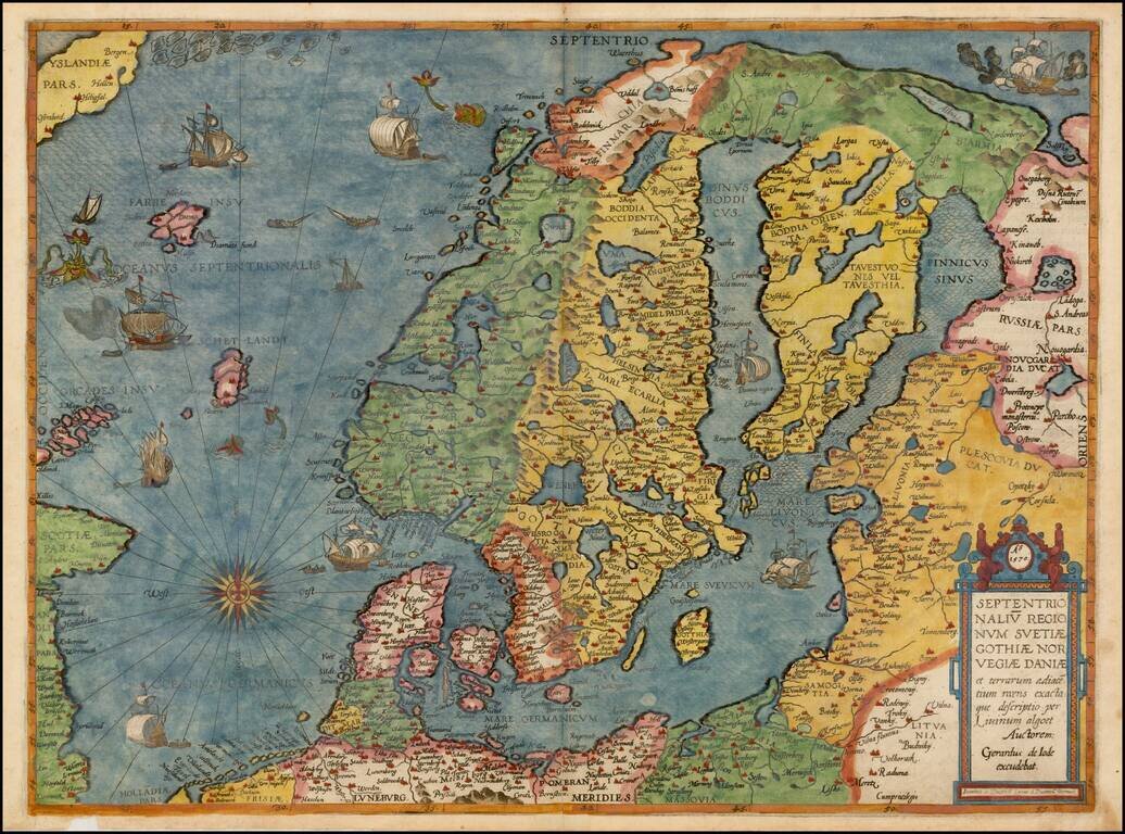
Colored example of De Jode's map of Scandinavia, the Baltic and Gulf of Finland, extending from Iceland and the Coast of Scotland to Novograd, St. Petersburg and the Norwegian Sea. The map is richly engraved by Joannes and Lucas van Deutecum's,...
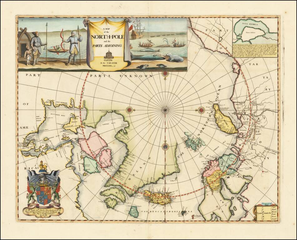
Remarkable Early English Map of the North Polar Regions Fine example of Moses Pitt's original map of the North Pole and surrounding lands. Moses Pitt initially set out to produce an expanded edition of Jansson's Atlas Maior with his partner Jacob Van...
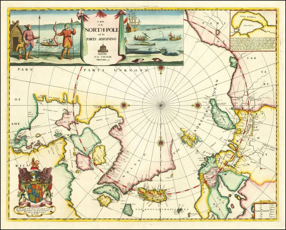
Remarkable Early English Map of the North Polar Regions Fine example of Moses Pitt's original map of the North Pole and surrounding lands. Moses Pitt initially set out to produce an expanded edition of Jansson's Atlas Maior with his partner Jacob Van...
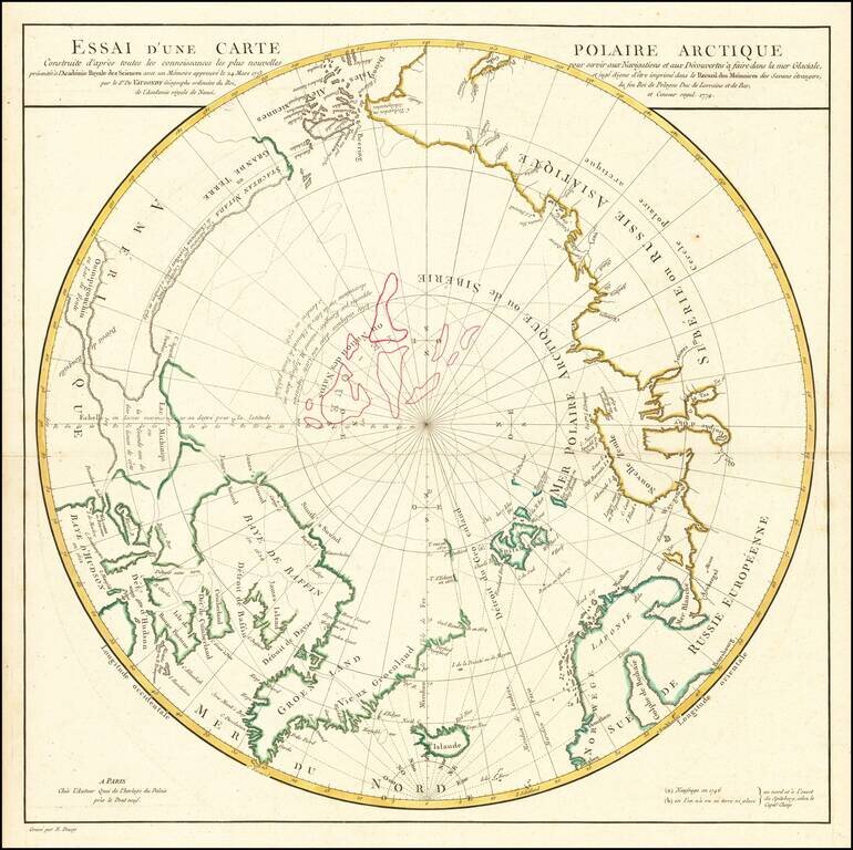
A Cartographic Landmark -- De Vaugondy's Presentation to the French Royal Academy on the Most Practicable Sailing Routes to the Pacific via the North Polar Regions Extremely rare polar map produced to illustrate a presentation made by Didier Robert...