
![[Bavaria] Vindeliciae Sive Utriusque Bavariae Secundum antiquum & recentiorem situm, ab Joanne Auetino olim descriptus, Principibusque eiusdem regionis dedicatus, atque Landshuti editus Anno à Christo nato. 1533](/map/small/61449.jpg)
Scarce example of Ortelius' first map of Bavaria. This first state was issued from 1570 to 1572, with an additional 25 copies printed in 1573, before the second map of Bavaria was issued (Van Den Broecke 110). As noted in the title, the map is drawn...
![[Unrecorded Variant] Franciae Orientalis (Vulgo Frankenlant) Descriptio](/map/small/61676.jpg)
Detailed regional map showing the Main River from its sources to Frankfurt, published by Abraham Ortelius. This is an unrecorded variant, not in Van Den Broecke. Text on verso is similar to the 1570A in Van Den Broecke, but Vulgo is the first word,...
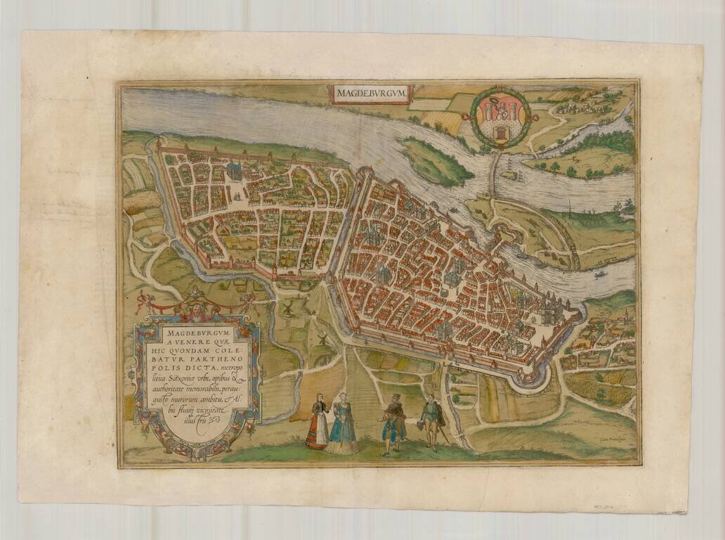
A fine early view of Magdeberg in Saxony, published by Braun & Hogenberg in their monumental 6 volume Civitatus Orbis Terrarum. TRANSLATION OF CARTOUCHE TEXT: Magdeburg was called Parthenopolis (virgin city) after Venus, who was once worshipped...

Old color example of this sheet of four important early views of Nuremberg, Saltzburg, Lindaw and Ulm, and Germany, on a single sheet. From Braun & Hogenberg's Civitatus Orbis Terrarum, the most important book of town plans and views published in...
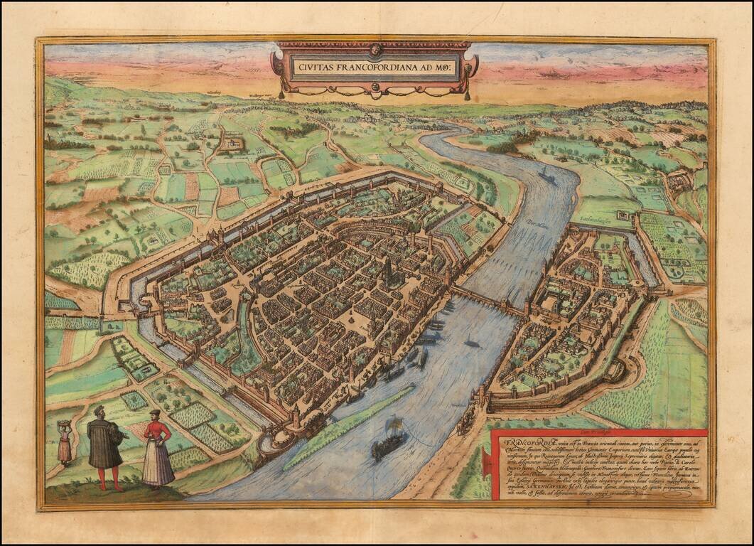
Important early view of Frankfurt am Rhein, from Braun & Hogenberg's Civitatus Orbis Terrarum, the most important book of town plans and views published in the 16th Century. Fine early bird's-eye view from the southwest. St Bartholomew's...
![[Augsburg] Augusta iuxta figuram quam his ce temporibus habet delineata](/map/small/54872mp2.jpg)
Fine early view of Augsburg, with two coats of arms and an extensive key locating important places, from Braun & Hogenberg's Civitas Orbis Terrarum, first published in 1572. The translation of the title cartouche is as follows: Following the...
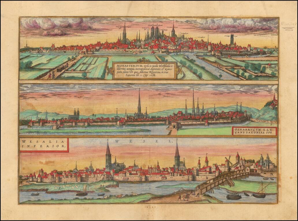
Three important early views of Osnabruck, Münster and Wesel in Northern Germany on a single sheet. From Braun & Hogenberg's Civitatus Orbis Terrarum, the most important book of town plans and views published in the 16th Century.
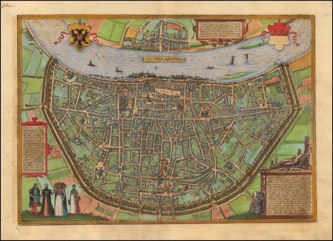
Nice old color example of Braun & Hogenberg's view of Koln (Cologne). TRANSLATION OF CARTOUCHE TOP: Divitense Munimentum is today known in the corrupted form of Tuitum and in popular speech as Deutz. Constantine the Great, son of Emperor...
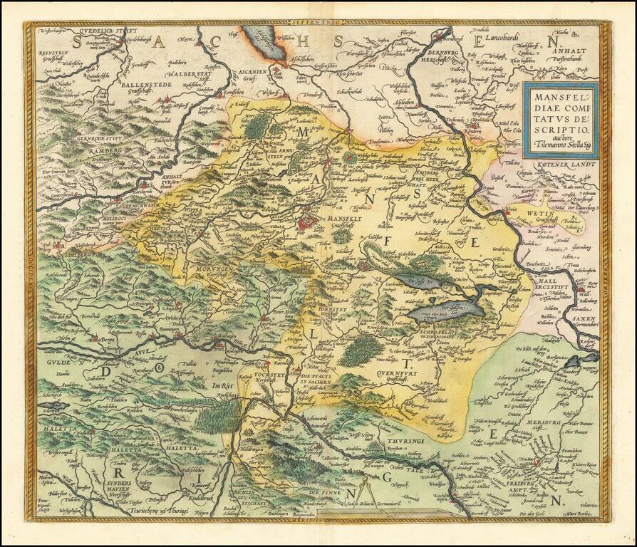
Nice old color example of Ortelius' regional map of Germany, centered on Mansfield and showing the Salsa River from Bernburgh to Rockendorf, and the Helm River, from Berga to Dorndorff. From Ortelius' Theatrum Orbis Terrarum, the first modern atlas of...
![Lubec . . . [and] Hamburch ein Vorneliche Han Stat. (Hamburg & Lubeck)](/map/small/41684mp2.jpg)
Nice old color example of this pair of birdseye views of Hamburg and Lubeck from an early edition of Braun & Hogenberg's Civitates Orbis Terrarum, the most prolific compilation of city views published in the 16th Century.
![(Mainz, Würzburg and Sion) Moguntia, Germaniae Metropolis, ad Rheni ripas Urbs Celeberrima, mercatorum frequentia . . . [and] Herbipolis Comuiter Wirtzburg Orientalis Franciae Metropolis [and] Sedunum, primaria & Metropolitica Valesiae urbs . . .](/map/small/55078mp2.jpg)
Nice old color views of Mainz, Würzburg and Sion (Sitten), from an early edition of Braun & Hogenberg's Civitates Orbis Terrarum, the most prolific compilation of city views published in the 16th Century.
![Heidelberga [and] Spira [and] Wormatia](/map/small/56492mp2.jpg)
Nice old color views of Heidelberg, Worms and Speyer, from an early edition of Braun & Hogenberg's Civitates Orbis Terrarum, the most prolific compilation of city views published in the 16th Century.
![[Munich, Regensburg, Ingolstadt, Nordlinga etc.] Monacum, Nominatissima Bavariae Civita (with) Ingolstadium (with) Nordlinga (with) Frisingensis (with) Ratispona (with) Straubinga](/map/small/58558mp2.jpg)
Nice set of 6 views of Southern German Cities, including Munich, Regensburg, Ingolstadt, Nordlinga, Frisinga, and Strauburg, etc. Includes manuscript notes in a contemporary hand.

Early double page birdseye view of Meissen, with Heraldic images and coats of arms in the sky. Munster's Cosmography was one of the most influential georgraphical works of the 16th Century. It was published in a number of editions over a half century...

Rare modern map of Bavaria, published in Cologne by Johannes Metellus in 1579 in fine original color. The map is one of the earliest obtainable modern maps published by the so-called Cologne School of mapmakers, which consisted primarily of Flemish and...

Rare modern map of the Mansfeld region, published in Cologne by Johannes Metellus in 1579 in fine original color. The map is one of the earliest obtainable modern maps published by the so-called Cologne School of mapmakers, which consisted primarily of...