Map size in jpg-format: 26.2838MiB
Click to open in high resolution (open in new tab).
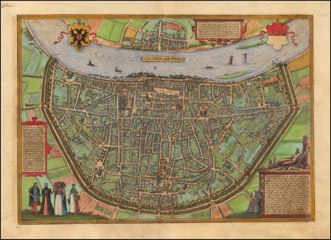
Nice old color example of Braun & Hogenberg's view of Koln (Cologne).
TRANSLATION OF CARTOUCHE TOP: Divitense Munimentum is today known in the corrupted form of Tuitum and in popular speech as Deutz. Constantine the Great, son of Emperor Constantius, built the fortress for soldiers to be garrisoned here and protected from Gaul; hence their unit was named Divitenses milites (they are mentioned by Ammianus Marcellinus in Book XXVI). Deutz is famed in our times for its magnificent Benedictine abbey, in which St Rupert, a native German philosopher, rhetorician, poet, astronomer and most industrious theologian, excelled in 1124 with the composition of many books.
CARTOUCHE BOTTOM LEFT: Concerning the bridge and insignia of the city of Cologne: in c. AD 310 M. Flavius Valerius Constantinus Maximus, son of Emperor Constantius, built in Cologne, as a sign of state sovereignty and to embellish the border of the Empire, a stone bridge whose construction was difficult but which was intended and required as a permanent protection against the Franks advancing towards Gaul. Around the year 962, however, Bruno, the archbishop of Cologne and brother of Emperor Otto I, had this bridge pulled down so that it would not be open to the Franks from the west. The insignia of this most prosperous city shows a silver-colored shield whose upper part (called the fetial or in the common tongue the head) bears three gold crown in a row on a red ground. These were adopted in place of three priest's caps in 1162, after the relics of the Magi were brought to Cologne. The regalia of the city are naturally characterized first and foremost by the jus apprehensionis and the claves portarum. [...]
CARTOUCHE BOTTOM RIGHT: The God of the Rhine. Cologne, a large, flourishing and magnificent city, the head and metropolis of the Lower or Second Germany, was initially an Ubii settlement. [...] On close proximity to the south lies the town of Bonn, to the north Neuss on the banks of the Rhine [...]. Owing to its position on the Rhine, the number and splendor of its churches, its large population spread across 23 city districts, and thanks to its highly regarded council, its clergy and university, Cologne is widely known and famed. Like Rome, it has St Peter as its patron saint. It is governed by Italian law. Cologne holds first place in the general assembly of the imperial cities. Within the famous Hanseatic League of 72 cities, Cologne is numbered amongst the leaders. It also maintains a permanent alliance with the Belgian and Burgundian nation. As a powerful city it is a welcome and intended safe and fortified seat for the Elector of the Holy Roman Empire, the Archbischop.
COMMENTARY BY BRAUN: "Cologne is a large and famous city in the country of Germany this side of the Rhine. It is known firstly for its church of unsurpassable size, the cathedral. It is built with wonderful art high into the sky out of stone hewn in a spirited manner and is dedicated to St Peter the Apostle. [...] The town hall of this city is particularly finely decorated; it has a tall and skillfully executed tower of ashlars and stones dressed with the aid of a level. The top of the town hall has many windows from which you can look out over the whole city. To the east, where the town hall faces the Alter Markt, is a beautiful gallery and a pretty clock."
The home of the author, Georg Braun, and the birthplace of his city atlas is seen in bird's-eye view from a steep angle. The plan clearly illustrates Cologne's large surface area and its characteristic semicircular ground plan fronting the Rhine. Thanks to the captions, the most important buildings can be easily identified. To the left of center the cathedral - the largest Gothic church in Germany, with towers 157 m in height - appears in distorted perspective. To its right lies the town hall described by Braun, together with the Alter Markt and the Heumarkt. Prominent in the lower half of the map is the Romanesque basilica of the Holy Apostles. A major city since Roman times, in 1288 Cologne became an imperial city. Close trading links with England encouraged its rapid economic growth and the Cologne exchange was founded in 1553. The crowded clocks illustrate the city's lively commercial traffic. From 1388 onwards the city was also the seat of a university, which was the first in the German-speaking territory to have been founded on the initiative of a town council. The Braun-Hogenberg map of Cologne was created specifically for the atlas and is one of the most valuable and accurate plans of the city as it stood in the 16th century, when it was home to some 40,000 inhabitants. (Taschen)
Georg Braun (1541-1622) was born and died in Cologne. His primary vocation was as Catholic cleric; he spent thirty-seven years as canon and dean at the church St. Maria ad Gradus, in Cologne. Braun was the chief editor of the Civitates orbis terrarum, the greatest book of town views ever published. His job entailed hiring artists, acquiring source material for the maps and views, and writing the text. In this role, he was assisted by Abraham Ortelius. Braun lived into his 80s, and he was the only member of the original team to witness the publication of the sixth volume in 1617.
If you are a student, write to us in telegram: @antiquemaps and indicate what material you need and for what work you need a map in high detail. We are ready to provide material on special terms. For students only!


