Map size in jpg-format: 5.82729MiB
Click to open in high resolution (open in new tab).

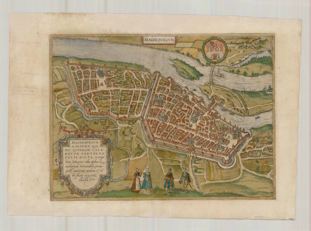
A fine early view of Magdeberg in Saxony, published by Braun & Hogenberg in their monumental 6 volume Civitatus Orbis Terrarum.
TRANSLATION OF CARTOUCHE TEXT: Magdeburg was called Parthenopolis (virgin city) after Venus, who was once worshipped here: it is the capital of Saxony, remarkable for its wealth and power and known for its narrow city walls and its proximity to the Elbe.
COMMENTARY BY BRAUN: "Magdeburg [...] is the noblest city in Saxony [...]. Here there are splendid houses, magificent streets, large and richly decorated churches: the church of St Maurice built by Emperor Otto is particularly handsome. In Magdeburg there used to be a fortified castle surrounded by fishermen's huts like a village or some other open bourg. There used to be burgraves here as in Nuremberg: whether they were Saxons or Vandals, however, is uncertain. It is known, that after Otto a burgraviate was created by Imperial mandate, and numbered amongst the four burgraves in the empire."
In this plan view seen from a lofty bird's-eye perspective, Magdeburg - the name is probably derived from 'Magadoburg" (German for mächtige Burg or "mighty fortress") - lies on the right bank of the Elbe. The Gothic cathedral of SS Maurice and Catherine is clearly recognizable on the right (Der Dom). Further left is the ensemble of St John's church, where Martin Luther preached in 1524, and the town hall overlooking the Alter Markt, the old market square on which it is also possible to make out the famous equestrian statue of the Magdeburg Knight and a Magdeburg Roland statue. (Taschen)
Georg Braun (1541-1622) was born and died in Cologne. His primary vocation was as Catholic cleric; he spent thirty-seven years as canon and dean at the church St. Maria ad Gradus, in Cologne. Braun was the chief editor of the Civitates orbis terrarum, the greatest book of town views ever published. His job entailed hiring artists, acquiring source material for the maps and views, and writing the text. In this role, he was assisted by Abraham Ortelius. Braun lived into his 80s, and he was the only member of the original team to witness the publication of the sixth volume in 1617.
If you are a student, write to us in telegram: @antiquemaps and indicate what material you need and for what work you need a map in high detail. We are ready to provide material on special terms. For students only!


