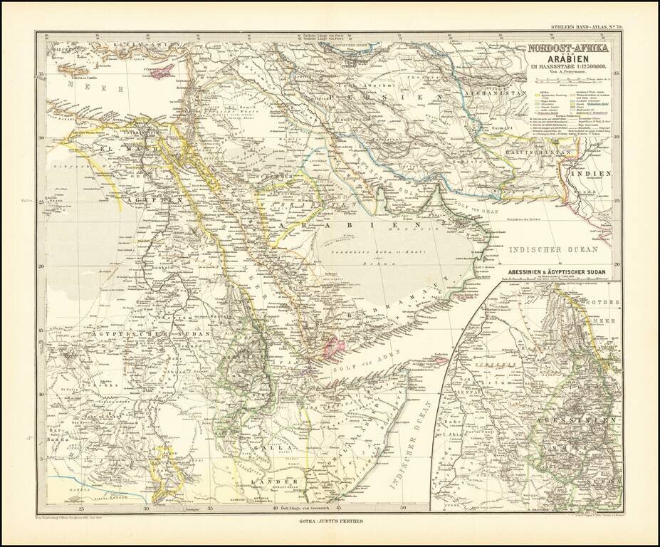
Finely detailed map centered on the Arabian Peninsula, published by Germany's leading mapmaker. Abu Dhabi is named (Abu-Debi), as is Schardscha (Sharjah), and Dibba. Katar (Qatar) is named, as is Sabara (Zubara), El Bedaa (Doha / El Bedaya) and Wakra...
![[Arabia] Kort over Ost og Centralarabien hovedsagelig omfattende de topograifske Resultater af Barclay Raunkiaer's Rejse 1912](/map/small/62032.jpg)
Raunkiaer’s Detailed Map of Central Arabia—An Early Traveler’s Map Finely-detailed map illustrating the travel route of Danish explorer Barclay Raunkiaer, whose early twentieth-century expedition proved to be a valuable primary source of...
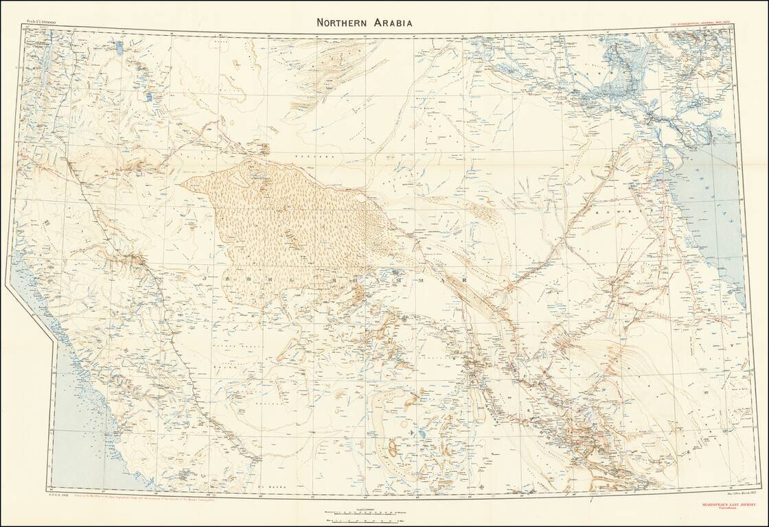
A Map to Illustrate Captain William Shakespear's Last Journey Highly detailed map was produced by the British War Office for the Royal Geographical Society with the permission of the controller of His Majesty’s Stationery Office in March 1922. The...
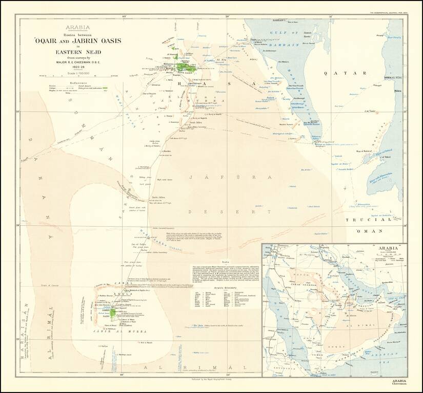
Mapping The Gulf of Salwah Finely executed map of Qatar and the region of Saudi Arabia to the west of Riyadh, published by the Royal Geographical Society in London. Cheesman was the first man to map the Arabian coast from the Gulf of Salwah to Uqair....
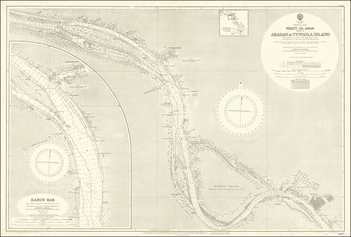
The Largest Oil Refinery In The World Detailed map of a section of the Karun River, on the Iran-Iraq Border, published by the British Admiralty. The map extends to Abadan and the complex of the Anglo-Persian Oil Company, which includes offices,...
![[Persia and the Middle East]](/map/small/63394kb.jpg)
Interesting circa 1930 map of Turkey, Iran, and the Middle East, in Ottoman Turkish. The map has insets of the Middle East and Iran, northern Greece, and elsewhere.
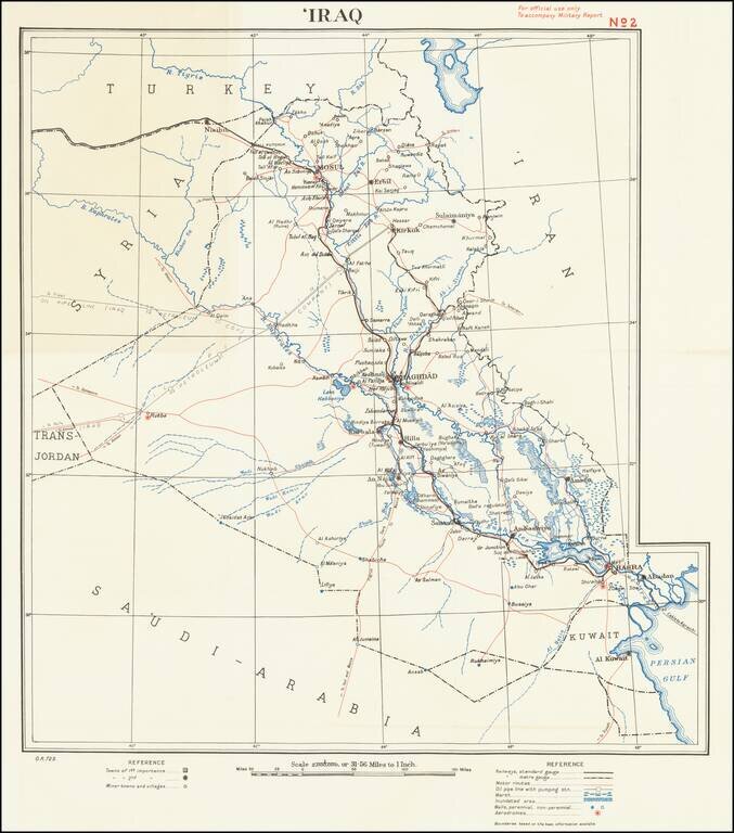
For official use only To accompany Military Report This is a simple and attractive military map of Iraq dating to the mid-twentieth century. The map is detailed, showing roads, cities, rivers, pipelines, cables, and more. Detail extends slightly into...
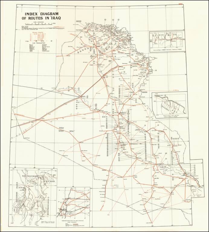
A detailed map of Iraq, produced shortly after the country's independence in 1932. The map shows routes, runways, and military installments, and was likely used in part for military purposes. Three insets detail bridges and routes in specific areas and...
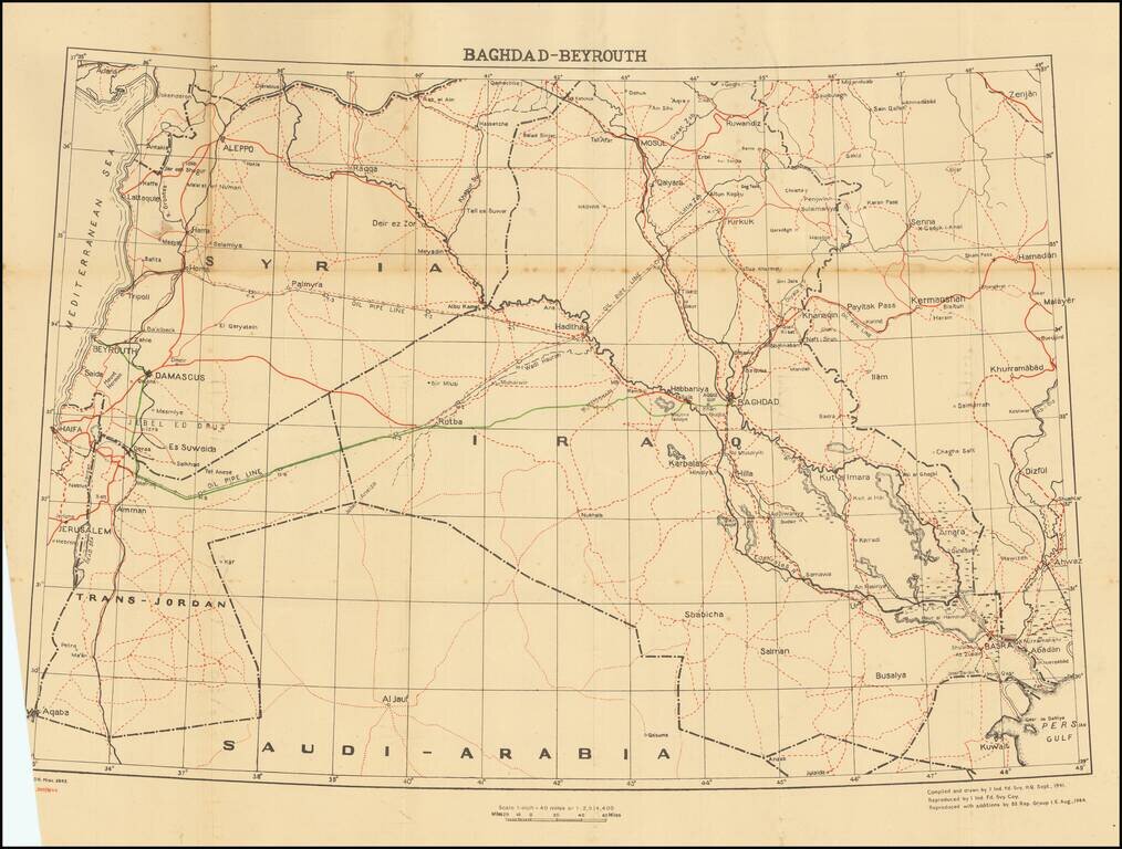
This is a fascinating map and pamphlet created for soldiers travelling in 1944 leave convoys. A major part of this journey included the road from Baghdad to Beirut, a 695-mile route through arid desert. Soldiers would head west from Baghdad until...
![Bandar Abbas [U.A.E. and Strait of Hormuz]](/map/small/67305.jpg)
Detailed Second World War-era map of the Strait of Hormuz and what is now the United Arab Emirates. This is the third edition of the map, published in 1945. This is one of the most detailed maps available from this era. It includes oil wells and oil...
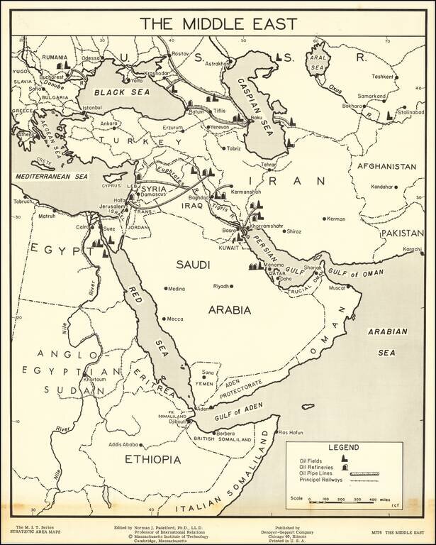
Large map of the Middle East, part of the Massachusetts Institute of Technology series of strategic area maps, issued in the 1950s. The map shows the earliest oil fields in the Middle East as they were just beginning large-scale exploitation in the...
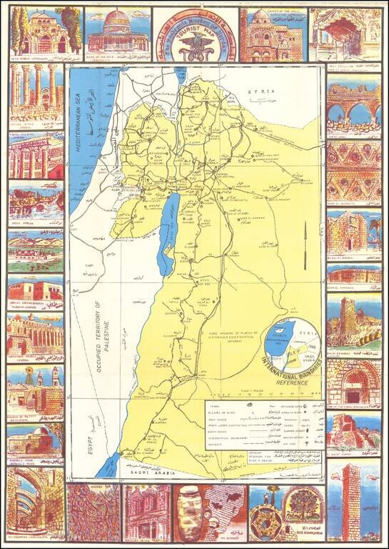
Jordan Makes the Most of Their Annexation of the West Bank. Scarce bilingual (English and Arabic) pictorial tourist map of Jordan, with extensive illustrations in the borders featuring the country's archaeological sites. The verso has maps of Amman...
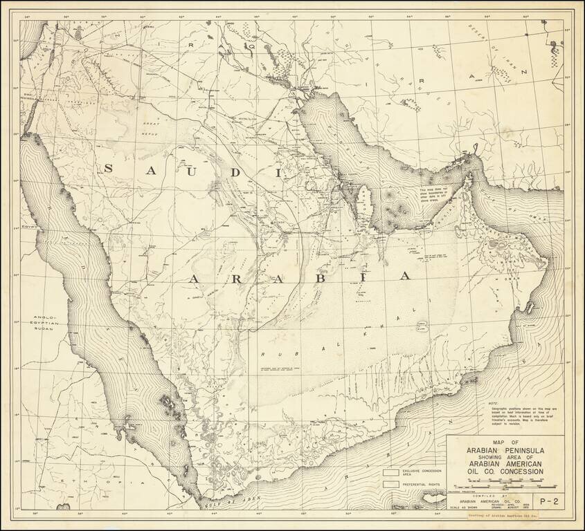
One of the earliest printed maps of Saudi Arabia to include the name Arabian American Oil Company (Aramco) Highly detailed map of Saudi Arabia, published by the Arabian American Oil Company in August 1951 and Revised in 1953. The map is one of the...
![Horuf | Restricted [Qatar and Bahrain] [on verso:] Bandar Abbas [U.A.E. and Strait of Hormuz]](/map/small/66777.jpg)
Detailed silk airman's map of Qatar and Bahrain and on the reverse and map of the present-day United Arab Emirates and Strait of Hormuz. The map has the U.K. Ministry of Defense Secrecy Rating "RESTRICTED". This is one of the most detailed maps...
![[Qatar and Bahrain] Hofuf](/map/small/67330.jpg)
Detailed World War Two-ear War Office map of Qatar and Bahrain. This is one of the most detailed maps available from this era. It includes oil wells and oil pipelines, which were barely beginning to be built when this map was made. This map is...
![תעלת סואץ [with] אל - עריש (Suez Canal; Al-Arish)](/map/small/67022.jpg)
A 1960s IDF Map of the Hotly-Contested Suez-Sinai Region. SECRET-rated, Hebrew-language, two-sheet Israeli Defense Forces map of the Suez Canal and north Sinai region. The base map is from the 1924 Ordinance Survey of Palestine, with revisions from...