

The Earliest Obtainable Map To Show Houtman's Crossing of the Indian Ocean to the Java, Opening The Spice Trade to The Dutch in 1597. Finely engraved map, showing the route of first Dutch fleet from Zuider Zee to Java in 1596-97, under the command of...
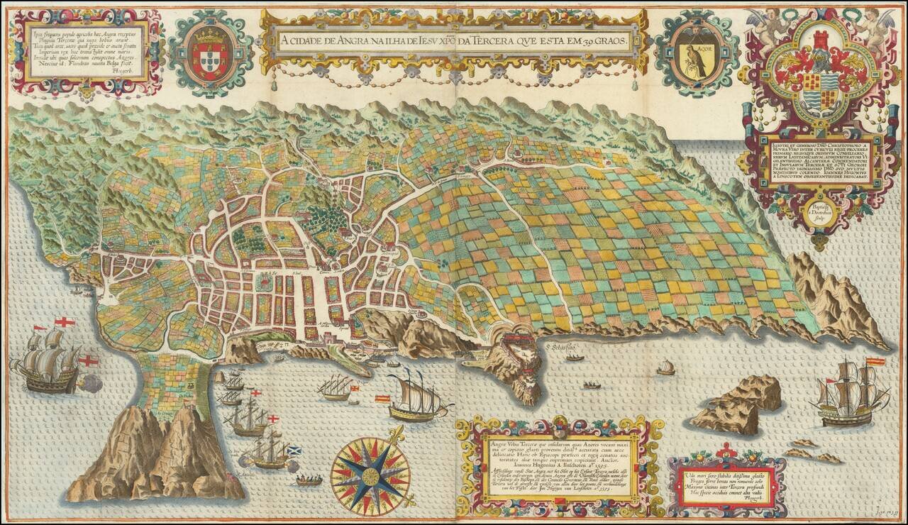
Spectacular birds-eye view of the island of Terceira and the town of Angra. Engraved by Baptista van Deutecum in Amsterdam, for LInschoten's Itinerario. Linschoten's view of Terceira in the Azores is one of the most decorative and recognizable...
![[Ascension Island] The True Description of the Island of Ascention lyeing under 8 degrees on ye South syde of ye Equinoctiall lyne.](/map/small/69468.jpg)
Antique engraved view of the Island of Ascension (St. Helena), which appeared in the rare English edition of Linschoten's Itinerario, Iohn Huighen van Linschoten. His discours of voyages . . . , published in London in 1598, and engraved by Englishman...

Rare sea chart of the Canary Islands, from Blaeu's Sea Atlas. Blaeu' Zeespiegel was one of the most important Rutters or Sea-Atlases of its time. Willem Janszoon Blaeu published two great pilot guides: the first ( Het Licht der Zee-vaert) was...
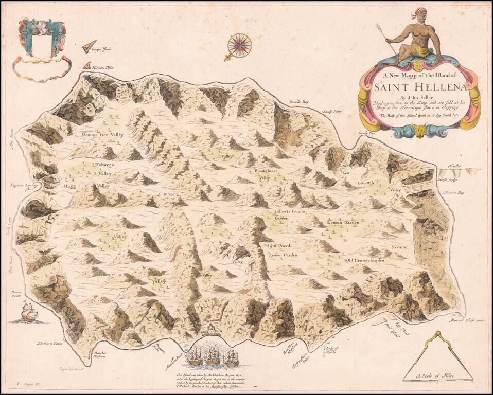
An English Rarity Rare separately published map of the Island of St. Helena, published by John Seller in London. This is the first map of St. Helena to be published in English and initially appeared in Seller's Atlas Maritimus . . . in 1675. The...
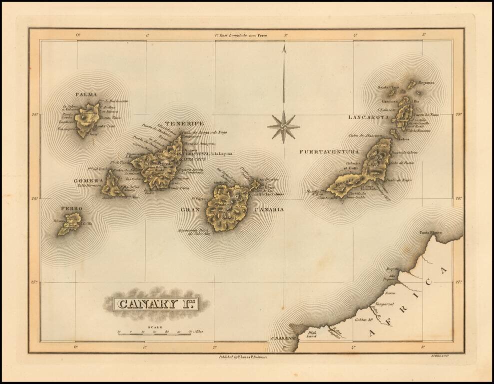
Scarce map of the Canary Islands by Fielding Lucas Jr., which appeared in his General Atlas, as well as his A New General Atlas of the West India Islands. Lucas's map is one of the first detailed commercial maps of the Canary Island published in...
![[Port Louis, Mauritius] Legende du Plan du Port-Louis](/map/small/51740.jpg)
Handsome and highly detailed manuscript map of Port Louis, the capital of Île-de-France (present-day Mauritius), done in pen and watercolor, showing the town, surrounding countryside, and the harbor, with many points keyed and identified in the...
![[Seychelles] A Chart of the Mahe and Amirantes Islands, with their Shoals by Monsr. le Vicomte Grenier 1776](/map/small/66725.jpg)
The First Commercially Published Map of the Amirantes and Seychelles First state of this rare early sea chart of the Seychelles, published by Robert Sayer in London. The chart covers the Mahe and Amirantes islands, also known as the Three Brothers...
![[Diego Garcia / Chagos Archipelago] Track of the Calcutta East Indiaman, over the Bassas de Chagas, in the Indian Ocean](/map/small/66729.jpg)
Rare separately published sea chart of the Chagos Archipelago, published in London by Sayer. Chagos Archipelago Portuguese explorers were the first Europeans to discover the archipelago. Portuguese navigator Pedro de Mascarenhas (1470 – 23 June...
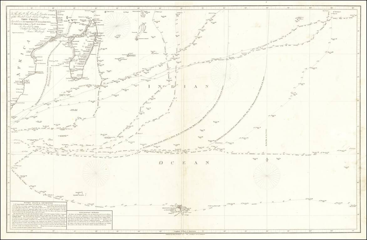
Provides one of the First Accurate Descriptions of Bouvetøya A detailed and fascinating chart of the South Indian Ocean, showing some of the most important journeys of the late 18th and early 19th centuries. This includes Cook's 1776 voyage and du...
![Islands in the Atlantic [Bermuda, Madeira, Canaries, Azores and Cape Verde Islands]](/map/small/48484.jpg)
Terrific map of the various islands in the Atlantic, including Bermuda, the Azores, Madeira, the Canaries and Cape Verde Islands, with 5 large profile views. Engraved for R. Montgomery Martin's Illustrated Atlas. Tallis was one of the last great...
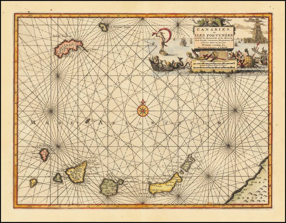
Decorative map of the Canary Islands, published in Leiden by Pierre Van der Aa. Includes an elaborate title cartouche and vignette.
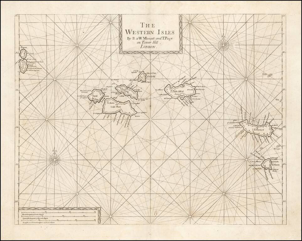
An Early Engish Sea Chart of the Azores Fine early chart of the Azores, which appeared in the English Pilot First Part, Southern Navigation.
![Les Isles Canaries . . . [With inset map of the Islands of Madeira and Porto-Santo]](/map/small/70853.jpg)
Detailed map of the Canary Islands, from De Vaugondy's Atlas Portatif, Universal et Militaire. Large inset of Madera and Porto Santo. Lots of place names shown.
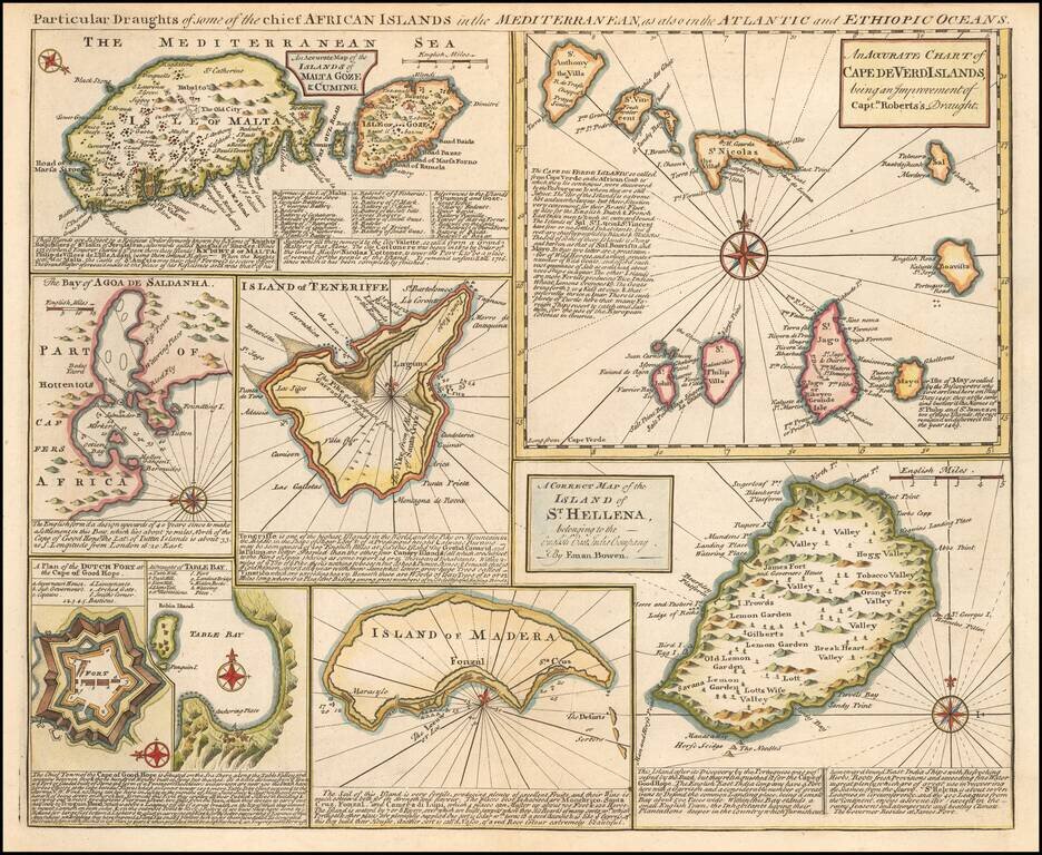
Detailed set of 8 maps, including a large and detailed Malta, the Bay of Agoa de Saldanha, Teneriffe, the Dutch Fortress at the Cape of Good Hope, Table Bay, Madera, St. Helena and the Cape Verde Islands, all with extensive annotations.
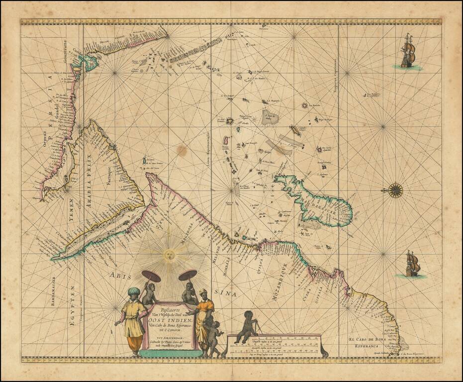
Charting the Western Indian Ocean Decorative sea chart of the Indian Ocean, orientated with the north to the left. The highly decorative chart shows the East African coast, Arabia, Madagascar and the islands of the Indian Ocean with the Seychelles...