
![[Augsburg] Augusta iuxta figuram quam his ce temporibus habet delineata](/map/small/54872mp2.jpg)
Fine early view of Augsburg, with two coats of arms and an extensive key locating important places, from Braun & Hogenberg's Civitas Orbis Terrarum, first published in 1572. The translation of the title cartouche is as follows: Following the...
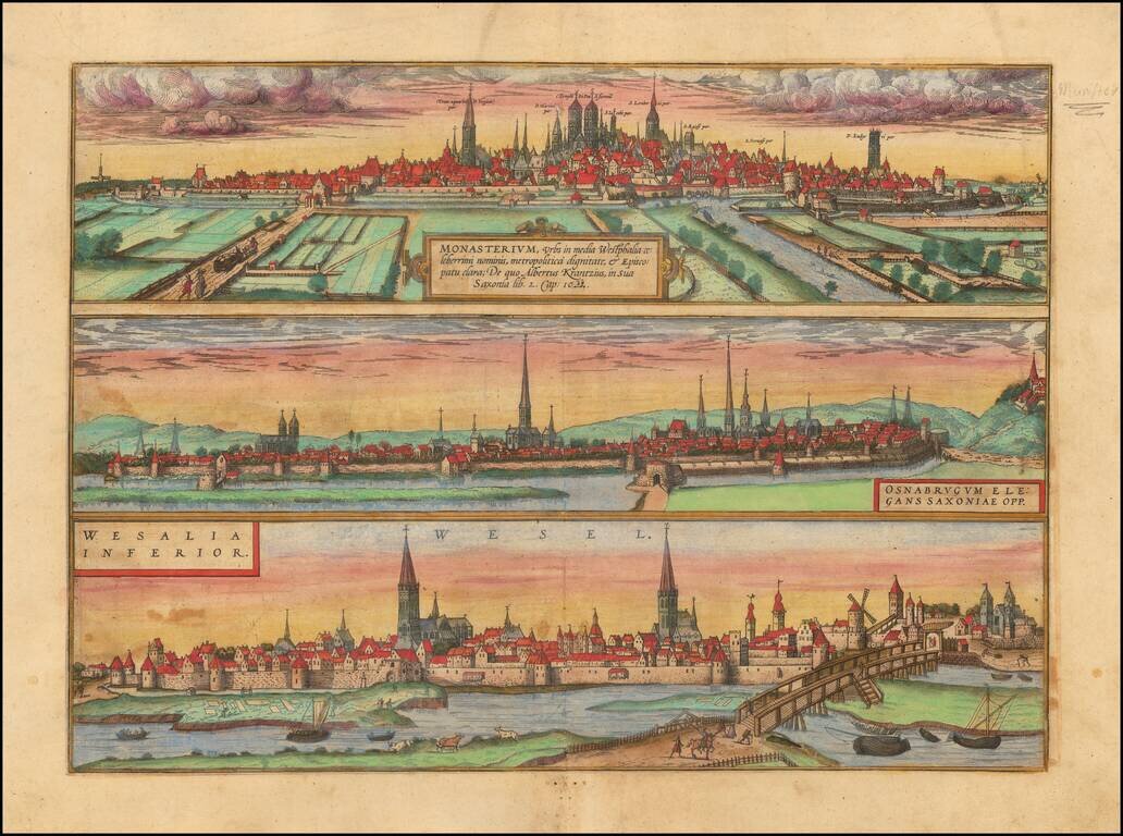
Three important early views of Osnabruck, Münster and Wesel in Northern Germany on a single sheet. From Braun & Hogenberg's Civitatus Orbis Terrarum, the most important book of town plans and views published in the 16th Century.
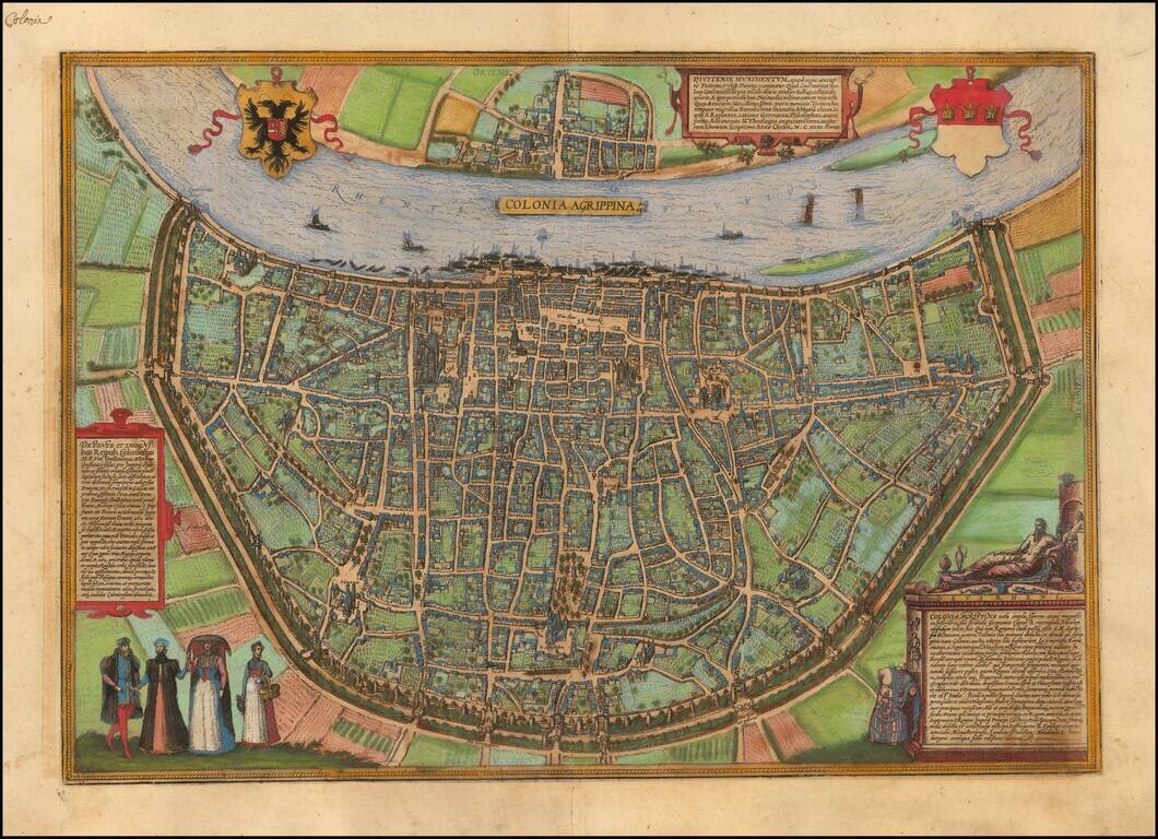
Nice old color example of Braun & Hogenberg's view of Koln (Cologne). TRANSLATION OF CARTOUCHE TOP: Divitense Munimentum is today known in the corrupted form of Tuitum and in popular speech as Deutz. Constantine the Great, son of Emperor...
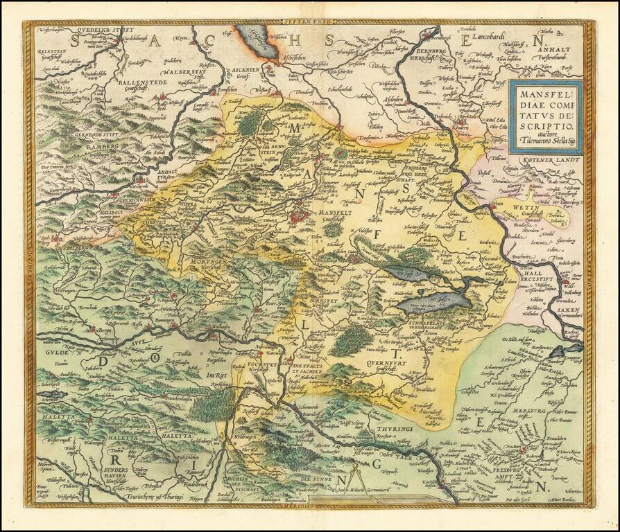
Nice old color example of Ortelius' regional map of Germany, centered on Mansfield and showing the Salsa River from Bernburgh to Rockendorf, and the Helm River, from Berga to Dorndorff. From Ortelius' Theatrum Orbis Terrarum, the first modern atlas of...
![Lubec . . . [and] Hamburch ein Vorneliche Han Stat. (Hamburg & Lubeck)](/map/small/41684mp2.jpg)
Nice old color example of this pair of birdseye views of Hamburg and Lubeck from an early edition of Braun & Hogenberg's Civitates Orbis Terrarum, the most prolific compilation of city views published in the 16th Century.
![(Mainz, Würzburg and Sion) Moguntia, Germaniae Metropolis, ad Rheni ripas Urbs Celeberrima, mercatorum frequentia . . . [and] Herbipolis Comuiter Wirtzburg Orientalis Franciae Metropolis [and] Sedunum, primaria & Metropolitica Valesiae urbs . . .](/map/small/55078mp2.jpg)
Nice old color views of Mainz, Würzburg and Sion (Sitten), from an early edition of Braun & Hogenberg's Civitates Orbis Terrarum, the most prolific compilation of city views published in the 16th Century.
![Heidelberga [and] Spira [and] Wormatia](/map/small/56492mp2.jpg)
Nice old color views of Heidelberg, Worms and Speyer, from an early edition of Braun & Hogenberg's Civitates Orbis Terrarum, the most prolific compilation of city views published in the 16th Century.
![[Munich, Regensburg, Ingolstadt, Nordlinga etc.] Monacum, Nominatissima Bavariae Civita (with) Ingolstadium (with) Nordlinga (with) Frisingensis (with) Ratispona (with) Straubinga](/map/small/58558mp2.jpg)
Nice set of 6 views of Southern German Cities, including Munich, Regensburg, Ingolstadt, Nordlinga, Frisinga, and Strauburg, etc. Includes manuscript notes in a contemporary hand.

Early double page birdseye view of Meissen, with Heraldic images and coats of arms in the sky. Munster's Cosmography was one of the most influential georgraphical works of the 16th Century. It was published in a number of editions over a half century...

Rare modern map of Bavaria, published in Cologne by Johannes Metellus in 1579 in fine original color. The map is one of the earliest obtainable modern maps published by the so-called Cologne School of mapmakers, which consisted primarily of Flemish and...

Rare modern map of the Mansfeld region, published in Cologne by Johannes Metellus in 1579 in fine original color. The map is one of the earliest obtainable modern maps published by the so-called Cologne School of mapmakers, which consisted primarily of...

Nice old color example of Ortelius' regional map of Germany, showing the Fuld region, with decorative cartouche, compass rose, etc. From Ortelius' Theatrum Orbis Terrarum, the first modern atlas of the World. Half of two sheet map.
![[Weimar, Erfurt, Jena, Fuld, Gotha ] Weimaria / Iena . . . / Erdfordia . . . / Gotha . . . / Fuldensis . . .](/map/small/58637mp2.jpg)
Important early views of the German Cities of Weimar, Erfurt, Jena, Fuld and Gotha, which appeared in Braun & Hogenberg's Civitatis Orbis Terrarum, the most important collection of city views and plans published in the 16th Century.
![Pomeraniae, Wandalicae Regionis Typ [with] Livoniae Nova Descriptio [with] Ducatus Oswieczensis, et Zatoriensis, Descriptio](/map/small/43172.jpg)
Finely colored example of Ortelius' maps of Pomerania, Latvia and part of Southern Poland above the Carpathian Mountains, from Ortelius Theatrum Orbis Terrarum.
![Hassiae Descriptio . . . [with] Holsatiae Descrip.](/map/small/46478.jpg)
Nice pair of regional maps of Germany, including decorative cartouches, etc. The Hassiae map extends to the Rhine and shows Frankfurt, and extends up to the Werra and Fulda Rivers. The Holsatiae map extends from Hamburg and Louwenburg in the south to...
![Thietmarsiae, Holsaticae Regionis Partis Typus Auctore Petro Boeckel [with] Prussia Descriptio ante aliquot annos ab Henrico Zellio ab coque D. Ioanni Clur. civi Gedanesi Ded:](/map/small/45904.jpg)
Ortelius’ Maps of Prussia and Holstein, from the First Modern Atlas Fine maps of Prussia and Holstein, printed on the same plate, that featured in Ortelius’ famous and groundbreaking atlas Theatrum Orbis Terrarum. The map on the right shows...