
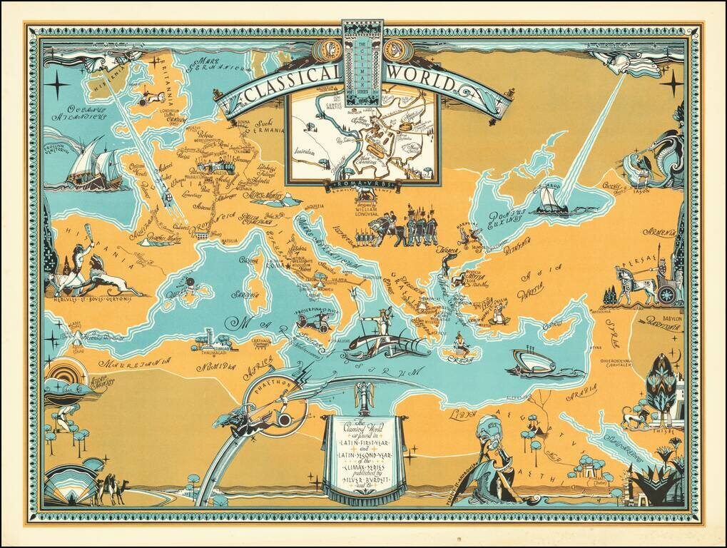
Rare pictorial map centered on the Mediterranean Sea, showing the world at the time of the Roman Empire, with place names in Latin. The map was produced for educational purposes to accompany a series of Latin textbooks published by Silver Burdett...

Extremely rare separately published pictorial map published by the British Israel World Federation (BIWF) on the 30th anniversary of its founding. The BIWF espouses the following tenants: that the descendants of the Lost Ten Tribes of Israel migrated...
![[Rare Complete Example with Game Pieces] Grand Circuit Des Capitales. Collection Concours Du Chocolat Menier](/map/small/70922rd.jpg)
Fine promotional map for Menier Chocolat. This example is quite unusual, in that it includes the 120 game pieces at the bottom of the map, still attached. Most examples come w/o the game pieces. The Menier Chocolate company was a chocolate...
![[Early Fascimile of the Disputed Christopher Columbus Portolan Chart]](/map/small/66571.jpg)
Early Photographic Facsimile of a 15th Century Portolan Chart Attributed By One Scholar To Christopher Columbus. From the Collection of Famous Map Scholar Edward Luther Stevenson. An impressive early facsimile of the "Columbus Mappa Mundi", which...

Willem Barentsz's Map of the Polar Regions, drawn from his observations during his third voyage of 1596-97 and engraved by Baptiste Van Deutecum. The Barentsz map of the polar regions is a major landmark in Arctic cartography, depicting the details...

Willem Barentsz's Map of the Polar Regions, drawn from his observations during his third voyage of 1596-97 and engraved by Baptiste Van Deutecum. The Barentsz map of the polar regions is a major landmark in Arctic cartography, depicting the details...
![[Spitzbergen & Wiches Lande]](/map/small/61990.jpg)
Mapping the early whaling voyages of the Muscovy Company Scarce early map of Spitzbergen, flanked by nine scenes of whaling, fishing, processing & bear hunting, and walruses (here called Seamorces), which first appeared in Purchas His Pilgrims...
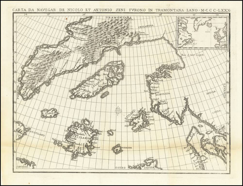
The Zeno Brothers Discoveries in the North Atlantic in the 14th Century Fine dark impression of this fine large format example of Nicolo Zeno's map of the North Atlantic, based upon the legend of a 14th Century Venetian family and their reported...
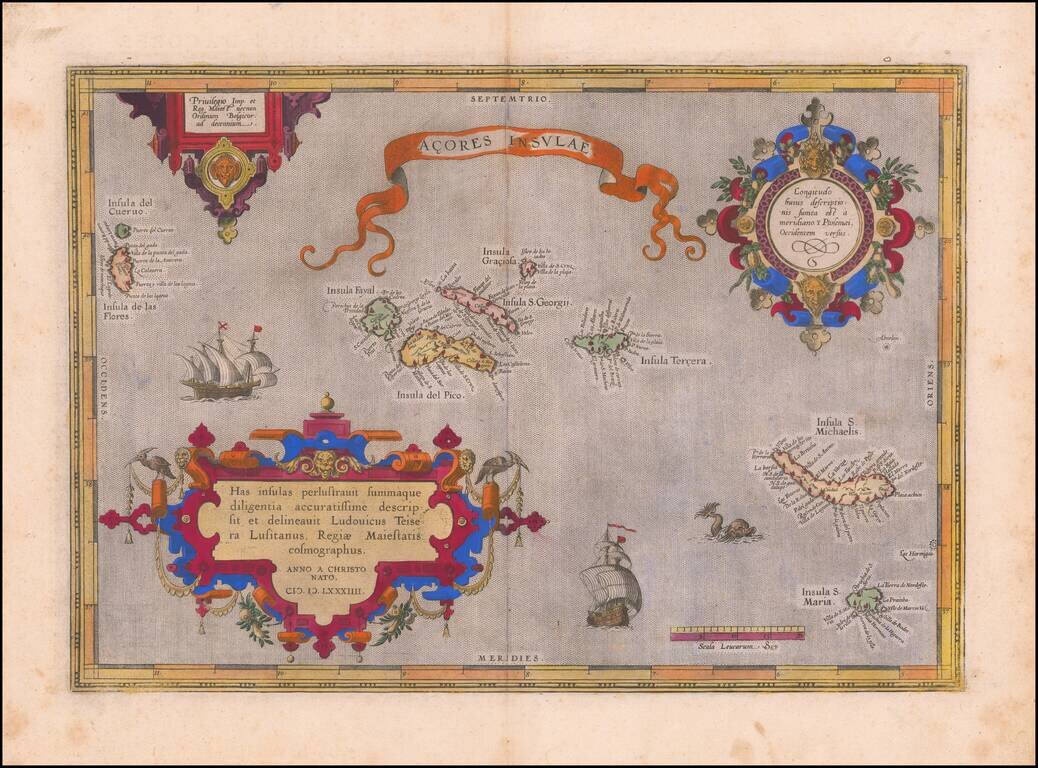
Old color example of Ortelius' map of the Azores, one of the most important destinations of explorers and early commercial mariners in the 16th Century. The size and detail of the map reflects the strategic importance of the Azores during the 16th...

Fine old color example of Ortelius' map of the Azores, one of the most important destinations of explorers and early commercial mariners in the 16th Century. The size and detail of the map reflects the strategic importance of the Azores during the 16th...

Ortelius' Map of the North Atlantic Old color example of Abraham Ortelius's important early map of the North Atlantic, extending from Scandinavia and the Polar regions in the East, to the mythical Islands of the North Atlantic, Greenland, Iceland and...
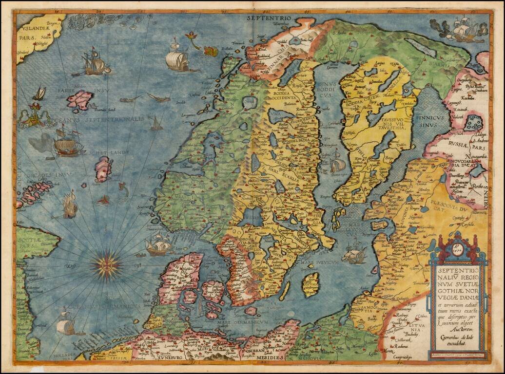
Colored example of De Jode's map of Scandinavia, the Baltic and Gulf of Finland, extending from Iceland and the Coast of Scotland to Novograd, St. Petersburg and the Norwegian Sea. The map is richly engraved by Joannes and Lucas van Deutecum's,...
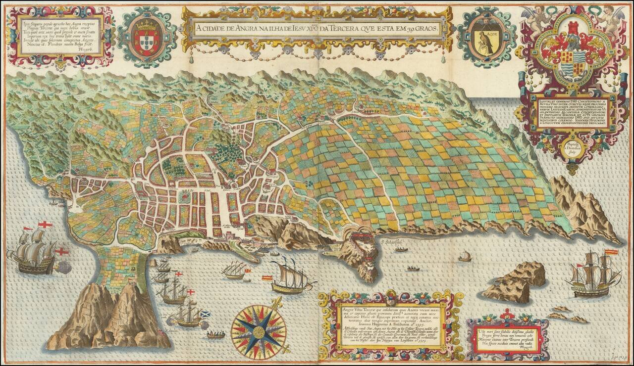
Spectacular birds-eye view of the island of Terceira and the town of Angra. Engraved by Baptista van Deutecum in Amsterdam, for LInschoten's Itinerario. Linschoten's view of Terceira in the Azores is one of the most decorative and recognizable...
![[Angra - Madera - Porto Santo - Sao Miguel] Pascaarte vande Eijlanden van Madera en Port Sancto, vertoonende degelegentheijt vande Reede aldaer en hoese van malcanderen zijn gheleghen . . .](/map/small/62128.jpg)
Early Sailing Chart of the Madeira, Angra and Sao Miguel. Rare sea chart showing the islands of Madeira and Porto Santo, with smaller maps showing Angra and a portion of Sao Miguel. The chart appeared in J Blaeu's Het Licht der Zee-vaert , first...

Henry Hudson's Final Sea Chart, One of the First Maps to Show Hudson Bay This remarkable chart illustrates the track of the fourth and final voyage of Henry Hudson in his hunt for a Northwest Passage. It was a landmark map in the exploration of the...

Rare sea chart of the Canary Islands, from Blaeu's Sea Atlas. Blaeu' Zeespiegel was one of the most important Rutters or Sea-Atlases of its time. Willem Janszoon Blaeu published two great pilot guides: the first ( Het Licht der Zee-vaert) was...