

![[Europe: Air Mail Routes] Carte des lignes postales aeriennes internes et internationales Europe pubilee par le Bureau International de l'Union postale universelle Berne, Avril 1937](/map/small/41144.jpg)
Postal map of Europe, showing the various domestic and international air postal routes. Includes German, Belgian, British, French, Dutch and Polish postal lines.
![Patriarchatus Antiocheni Geographica Descriptio . . . [shows Cyprus]](/map/small/54177.jpg)
The Cradle of Civilization Rare and highly decorative map of the region bounded by Cyprus and the Holy Land in the west and Sinus Persicus and Susiana in the east. Toward the center is the confluence of the Tigris and Euphrates rivers.
![[Facsimile - 15th Century Portolan Sea Chart] Portolan des Iehuda ben Zara](/map/small/64285.jpg)
Impressive modern facsimile of the Iehuda Ben Zara portolan of the Mediterranean from 1497. The beautiful chart extends from the British Isles in the northwest to the Red Sea in the southeast and depicts all of the Mediterranean with the exception of...

Rare Pair of Broadsides Illustrating The Gunpowder Plot, engraved by Crispin Van Passe. Top Image Eygentliche Abbildung wie ettlich Englische Edelleut einen Raht schliessen den König sampt dem gantzen Parlament mit Pulfer zuvertilgen Above, the...
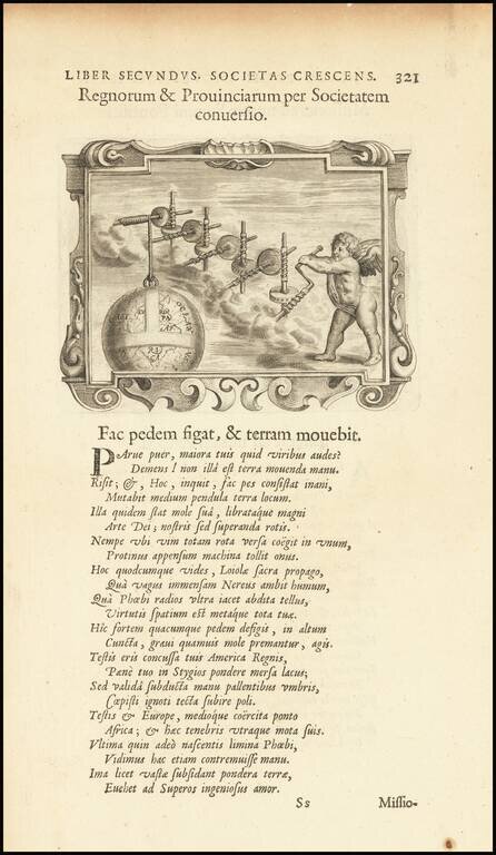
Interesting image of a cherub rotating the earth, from a rare Jesuit emblem book, entitled Imago Prrimi Aaeculi Soc. Iesu a Provincia Flandro-Belgica Ejusdejm . . .

Rare early allegorical print, published in London. The view has been attributed to Wencaslaus Hollar. A cedar tree representing the traditional episcopal church, inscribed on the trunk 'The Church Catholick', with two smaller shoots from the trunk...

This is an unusual thematic chart shows the traveling distances from various European cities in a style that is still used today. Several similar charts were made during this time, but this one gives a very large number of combinations, some nearly...
![[Hand Drawn Prussian Military Encampment at Opole, Poland] Special Grund-Riss Des Kaeyserl Feldl Lagers bey Oppeln in Ober Schlesien](/map/small/59726.jpg)
Rare Manuscript Plan of a Prussian Military Encampment Mid-eighteenth-century plan of a Prussian military camp located near Opole, made at a time when the Prussian army was one of the strongest in the world. This document is a rare survival and...
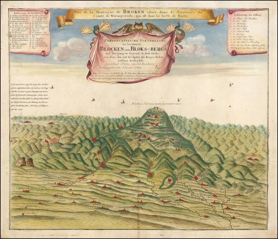
The Legendary Home of Witches and Devils This is a rare and very unusual map of Blocksberg mountain, the highest of Germany's Harz Mountains. The chart illustrates the Walpurgis Night (Walpurgisnacht) celebration. Walpurgisnacht is an ancient...
![Orange [Vauban Style Fortress]](/map/small/62043.jpg)
Refined Plan of a Star Fort and Walled Settlement in Orange, France. Manuscript plan outlining the fortress at Orange complete with moat, bastions, inner and outer walls, and several building outlines. The plan is finely wrought, showing similarities...

Sedition in New York in 1766, The Stamp Act, "America's Nabob", and the Origins of "Yankee Doodle". Rare engraved caricature of William Pitt the Elder, Earl of Chatham, represented as a Colossus straddling the Atlantic Ocean and attempting to gain...
![Carte d'Etude [Study Map]](/map/small/66795.jpg)
A superlative example of its kind; an 18th-century French manuscript map drawn by a student (possibly a student surveyor or military officer) to demonstrate competence in the art of classical map drafting. The map incorporates a diversity of...

A Rare Early Robert Havell, Jr. aquatint Rare illustration of the comparative heights of the various buildings and public places on the River Thames, published by Frederick Wood& William Moffat. While extremely rare, the map was apparently...
![Сны Султана (Картина 2) [Dreams of the Sultan. Scene 2]](/map/small/60238.jpg)
Russia Imagines the Ottoman Response to Crimean War Reversals. A fascinating ephemeral lithograph, this was apparently one of three "scenes" prepared during the Crimean War, and said to represent the Ottoman ruler's response to defeats during the...
![Повстанцы 1863 Года [(Polish) Insurgents of 1863]](/map/small/52719.jpg)
Three Vilnius-Published Prints of the January Uprising -- Polish National Uprising in 1863. A highly unusual, early Lubki (popular graphic) series, locally-published in Vilnius, Lithuania and depicting a contemporary nationalist revolt by the...