
![(Second World War - Allied Bombing of Germany) Offensive Aerienne des Allies contre l'Allemagne Jusqu'au 1 Fevrier 1941 [Allied Air Offensive against Germany Up To January 1st 1941]](/map/small/67411.jpg)
Broadside showing the location of bombing runs of the Allied bombers in Germany up to January 1, 1941. Inset map shows the heavy concentration of bombs in the Ruhr Valley, with a key locating the different types of facilities being bombed:...
![(Second World War - First Soviet Breakthrough into Germany) Генеральный Штаб Красной Армии - (Фюрстенвальде) | (Франкфурт) [General Staff of the Red Army - (Fürstenwalde) | (Frankfurt)]](/map/small/63108.jpg)
Manuscript-Annotated Map Showing Soviet Forces Entering Germany for the First Time! A fantastic map showing the first Soviet breakthrough into Germany-proper, during the leadup to the Battle of Berlin and the closing stages of the Vistula-Oder...
![(Second World War - Battle of Berlin) Генеральный Штаб Красной Армии Берлин-7 [General Staff of the Red Army Berlin-7]](/map/small/64471.jpg)
Detailed Soviet 1:100,000 map of Berlin, used during the Red Army encirclement of the city in the Battle of Berlin. The map covers several hundred square kilometers around Berlin, at the center is the city, labeled in Russian ("Берлин"). To the...
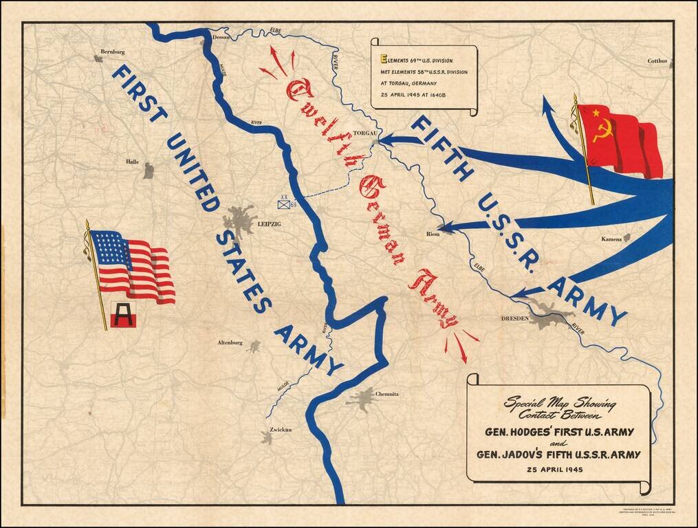
A Map Celebrating Elbe Day -- World War II Fine thematic map showing the progress of the American and Russian Forces against the last remnants of the German Army, published on Elbe Day. The two forces are shown moving toward each other, superimposed...
![(Second World War - Eastern Front) [The Soviet Encirclement of Konigsberg]](/map/small/65659.jpg)
Color-printed German map of East Prussia, with extensive manuscript additions in a Soviet hand noting the troop movements during the East Prussia Offensive and encirclement of Konigsberg. The Red Army movements are shown in red pencil, Wehrmacht...
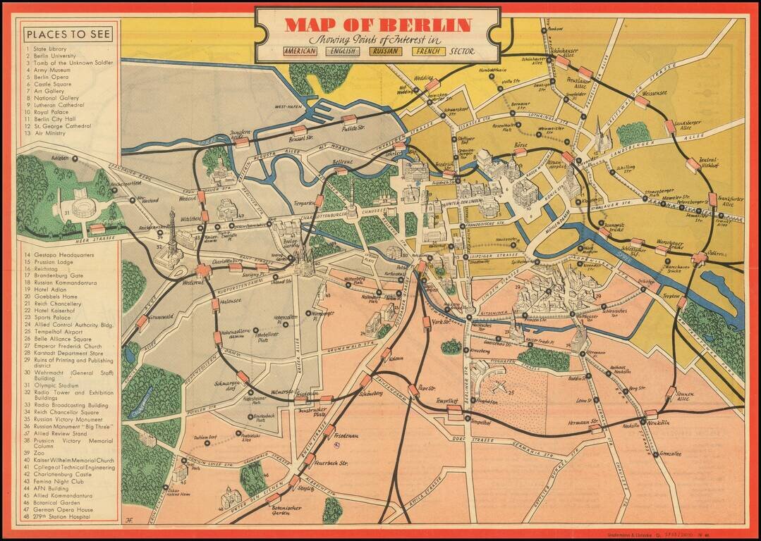
An attractive vintage pictorial map of Berlin during the earliest days of Allied occupation, preserving a rare view of the city prior to the building of the Berlin Wall. The front of the work depicts the heart of Berlin and its surroundings, stretching...
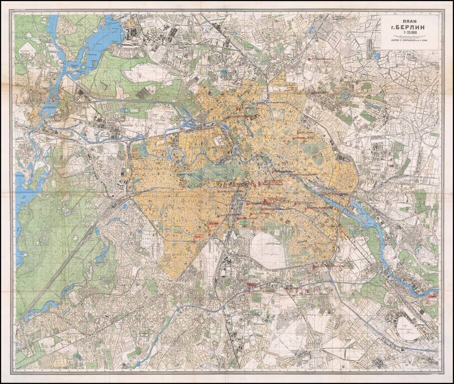
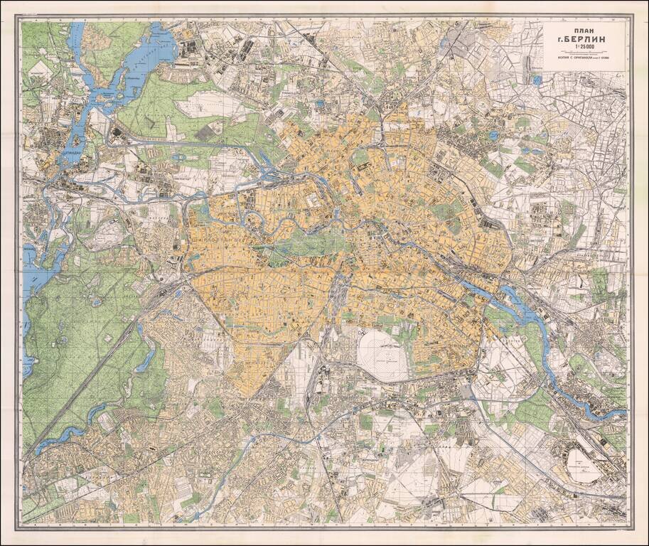
![[Battle of Berlin] План г. Берлин 1:25000](/map/small/68524.jpg)
"The Victory Map". The Official Soviet Map Used in the Battle of Berlin, April 1945. This is a color-printed folding map of Berlin, issued by the Soviet Union in 1945, shortly before the Fall of Berlin. Many examples of this map were used by...
A fascinating relic of mapmaking on the Eastern Front of World War II, being a field-printed map of Berlin and the surrounding area produced for one of the most infamous groups involved in the Second World War, the Отдел Контрразведки...
![[Pan American Airways Advertising Map -- Occupied Germany] Reise-Und Transport Verkehrskarte von Deutschland Mit Strassen- Und Eisenbahnmetz Zonen - Und Landergrenzen](/map/small/67100.jpg)
Promoting Pan American World Airways This colorful and attractive map depicts Germany and Central Europe in the immediate wake of World War II. The Allied Powers (United States of America, France, United Kingdom, and the Soviet Union) met at the...
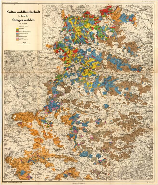
Cultural forest landscape in the Steigerwald of Germany, between Wurzberg and Nuremberg The map is color coded to show the predominant trees in each region.

Attractive print showing the hiking trails around Nesselwang and Wertarch in the Allagäu region of Swabian Bavaria. The area is shown from an aerial viewpoint, and was likely based off early aerial photographs. The region is one of the most...
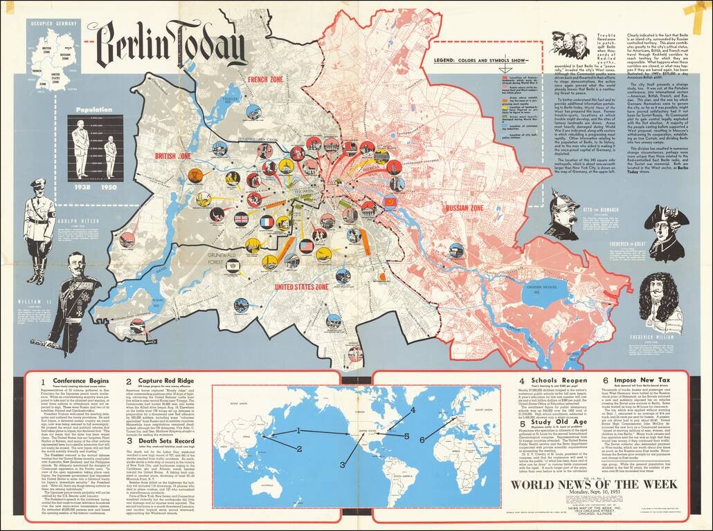
This is a detailed map of Greater Berlin, divided into its four occupied zones. Made at a time when the Cold War was at one of its many peaks, some recent conflicts had led to renewed public interest in the city, which had been the subject of its...
![Beverly Hills Farmer's Almanack Map Part One [and] Beverly Hills Farmer's Almanack Map Part Two](/map/small/64161jc.jpg)
"A Compilation of Fashionable Merchants Serving The Beautiful People" Whimsical promotional map of Beverly Hills, which appeared in the 1974 Beverly Hills Farmer's Almanack. Two marvelous whimsical maps of Beverly Hills, surrounded by advertising and...
![[Fall of Berlin - Operation Clausewitz] Umgebung von Berlin](/map/small/60025.jpg)
Extraordinary Defensive Plan of Berlin, Prepared by Nazi Forces on the Eve of the Soviet Capture of the City and the End of World War II in Europe. This Map was Captured by Soviet Soldiers and Bears an Inscription in Russian in the Upper Left Corner....
Mapping the Soviet Propaganda Machine in Occupied Berlin. Color-printed folding map of Berlin, issued by the Soviet government in 1945. This example is substantially enhanced with early (circa Spring 1945) manuscript notations of major printing and...
The Official Soviet Map Used in the Battle of Berlin, April 1945. Color-printed folding map of Berlin, issued by the Soviet Union in 1945. In many cases, these maps were carried into Berlin by front-line Red Army troops. The map was issued in...