Map size in jpg-format: 167.31MiB
Click to open in high resolution (open in new tab).
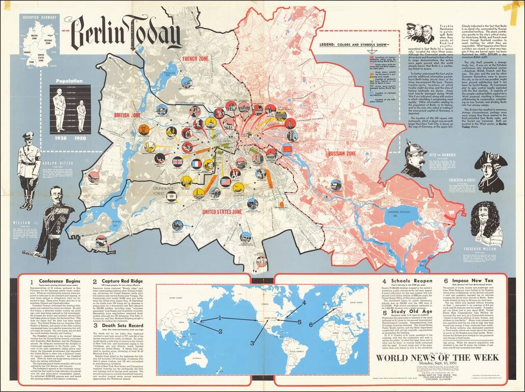
This is a detailed map of Greater Berlin, divided into its four occupied zones. Made at a time when the Cold War was at one of its many peaks, some recent conflicts had led to renewed public interest in the city, which had been the subject of its eponymous Airlift just two years prior.
The map itself is detailed and highly attractive. The French, American, British, and Russian Zones are all shown, with the last being colored in bright red. The map details famous landmarks, heavily damaged areas, areas where rebuilding has progressed most rapidly, and, perhaps most intriguingly, areas of recent strife. These can be found throughout the Allied-occupied and border areas, including the Brandenburg Gate, Soviet Memorial (in the British Zone), the Canal Locks, and Potsdamer Platz. These apparently refer to areas where Communist youths led demonstrations and protests before being pushed back into Russian-occupied areas.
The work includes various other features including a map of Occupied Germany, showing four Zones, although the region was now recognized as East and West Germany, at least nominally. The map also includes a population table showing the 25% decrease in population between 1938 and 1950. Images of important historical personalities including Hitler, William II (Kaiser Wilhelm), Otto von Bismark, Frederick the Great, and Frederick William are shown as well. At the bottom, a world map centers on the Americas.
The "World News of the Week Section" along the bottom of the map gives several tidbits of news, pertaining to the Korean War, the upcoming school year, and the Labor Day death toll (apparently two-thirds due to automobile accidents). One account tells of a new tax that Soviet authorities tried to impose on any shipping and bussing between West Berlin and West Germany. These new taxes were non-negligible and John McCloy denounced them as "aimed at starving millions of men, women, and children in free Berlin." The collectors apparently demanded Western Marks but only gave change and receipts in Eastern Marks, with the latter being worth five times less than the former.
If you are a student, write to us in telegram: @antiquemaps and indicate what material you need and for what work you need a map in high detail. We are ready to provide material on special terms. For students only!


