Map size in jpg-format: 154.742MiB
Click to open in high resolution (open in new tab).

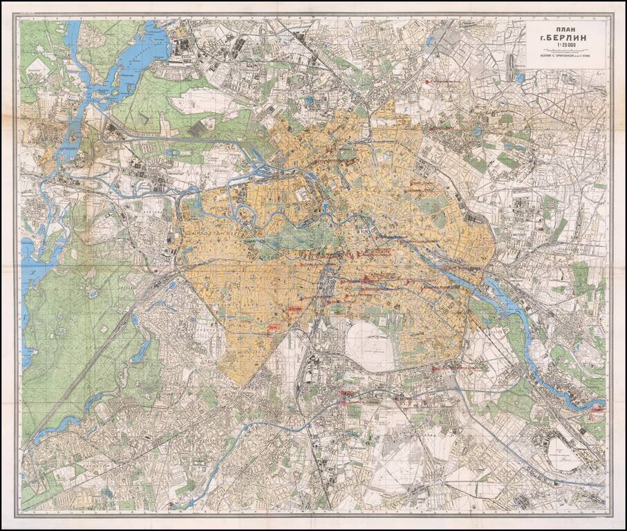
Mapping the Soviet Propaganda Machine in Occupied Berlin.
Color-printed folding map of Berlin, issued by the Soviet government in 1945. This example is substantially enhanced with early (circa Spring 1945) manuscript notations of major printing and publishing firms, factories, and warehouses. In addition to printing and publishing establishments, some Red Army forces are also marked in red pencil on the map. This map was probably carried and annotated by a political officer attached to the Red Army.
It is probable that this map was annotated between the May 2, 1945 surrender of Berlin and the July 1945 handover of the British, French, and American sectors by the Soviets, as per the London Protocol.
The printed map itself is quite interesting, as it was issued in several editions within 1945. It declares itself to be derived from the original 1:15,000 mapping of Berlin. The editions can be differentiated by the text and number in the far lower left corner of the map. This edition is "Зак. 813 IV 45 Д". We do not know how many editions were published, nor what the differences between editions are; this is a subject worthy of further research. The Soviets also produced a four-sheet 1:10,000 map of Berlin in 1944-45. It should be noted that the manuscript on this map is stylistically very similar to other annotated Soviet Berlin maps from 1945 that can be found in digitized collections online.
Publishing and Printing in Soviet-Controlled Berlin:
In the Spring of 1945, Decrees were signed by Nikolai Berzarin and others (one from April 30, 1945, another one from May 2, 1945) stating, among other major rules for civilians and former Nazi soldiers living in Berlin, that all the owners of printing houses and even owners of typewriters must register in a special list with the Russian military government. From the Spring of 1945, all the printing houses were controlled by Soviet commandants: they supervised workers' right of entry and all working activities. Throughout this period, Berzarin was overseeing the rebuilding of all the destroyed state services in Berlin, including the media. This map was probably used by the Soviets in managing the printing houses while they produced anti-Nazi and pro-Soviet propaganda, issued banknotes and food stamps, and produced periodicals.
Appendix - Selected Annotations:
3 Офсетно-Картогр. Ф-Ка "Цандер" : 3 Offset-Cartography Fabricator "Zander"
10 Типогр. "Альберт Фриш" : 10 Tipogr. [i.e., printer] "Albert Frisch"
12 Типогр. "Зайдель" : 12 Tipogr. "Seidel"
The Battle of Berlin
By early 1945, the Germans had all but lost the war on Eastern Front. The Red Army proved an unstoppable tidal wave, destroying the Wehrmacht division by division. Evacuation measures for Berlin had been prepared for the Reich government, ministries, and security apparatus starting in February of 1945. However, their implementation was delayed so that the commanders would not be seen to be admitting defeat. With two million Soviet soldiers quickly surrounding Berlin, Adolf Hitler finally gave the order to execute the defensive plan for the city on April 20th, 1945, his 56th birthday. The defenses barely slowed down the Red Army, and by early May they had totally subdued the city.
If you are a student, write to us in telegram: @antiquemaps and indicate what material you need and for what work you need a map in high detail. We are ready to provide material on special terms. For students only!


