
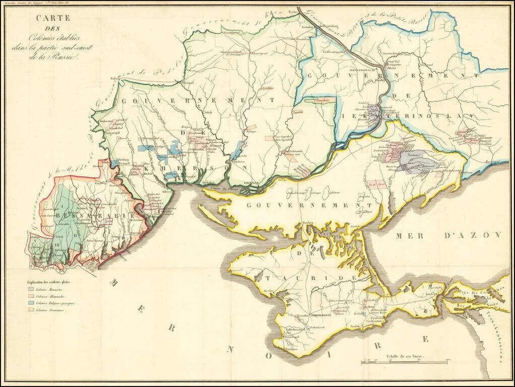
Detailed map of the Crimea and northern part of the Black Sea and Sea of Azof, locating colonial settlement in the region. The map is divided by Governments as created by the Imperial Russian Government in 1802 (and abolished in 1925). The...
![(Russian Adventurism in China) Карта Средней Азии Составлена К. Веберомъ... 1871. [Map of Central Asia Compiled by K. Weber... 1871.]](/map/small/58597.jpg)
The Russian Empire Eyes Western China. Important manuscript map of northern and western China and Mongolia prepared by K. Weber, Beijing, 1871, and copied by L. Brosse in St Petersburg. The map was the product of a major Russian expedition in China...

Detailed map of the Nova Zemla region, focusing on the polar voyages in the region in the 1870s. The following explorer routes are noted: Johannsen 1869 Johannsen 1870 F.C. Mack 1871 Johannsen 1871 Tobiesen 1871 Isacksen 1871 Dorma 1871 Rosenthal...
![[Plan of the City of Moscow] Планъ Города Москвы](/map/small/61305.jpg)
Detailed color-printed antique map of Moscow, published in 1881. The map divides Moscow into a grid with 127 sections (though not all are shown). It is signed by the Major General in charge of the Moscow City Police. At the top of the map is the Coat...
![[Transport Map of Russia: 'Map of the routes of Steamships, Communication lines, Railways and Roads in the Russian Empire'] Carta Parahodnyii Soobshenyii Zheleznyii i Poutovyii Dorog Rossiyskoi Imierin](/map/small/39456.jpg)
A large-format and highly detailed wall map detailing the transportation networks within Russia during the mid-1890s, the authoritative map by the firm of A. Ilyin, then Russia's foremost producer of Russian Cartography. This rare and very...
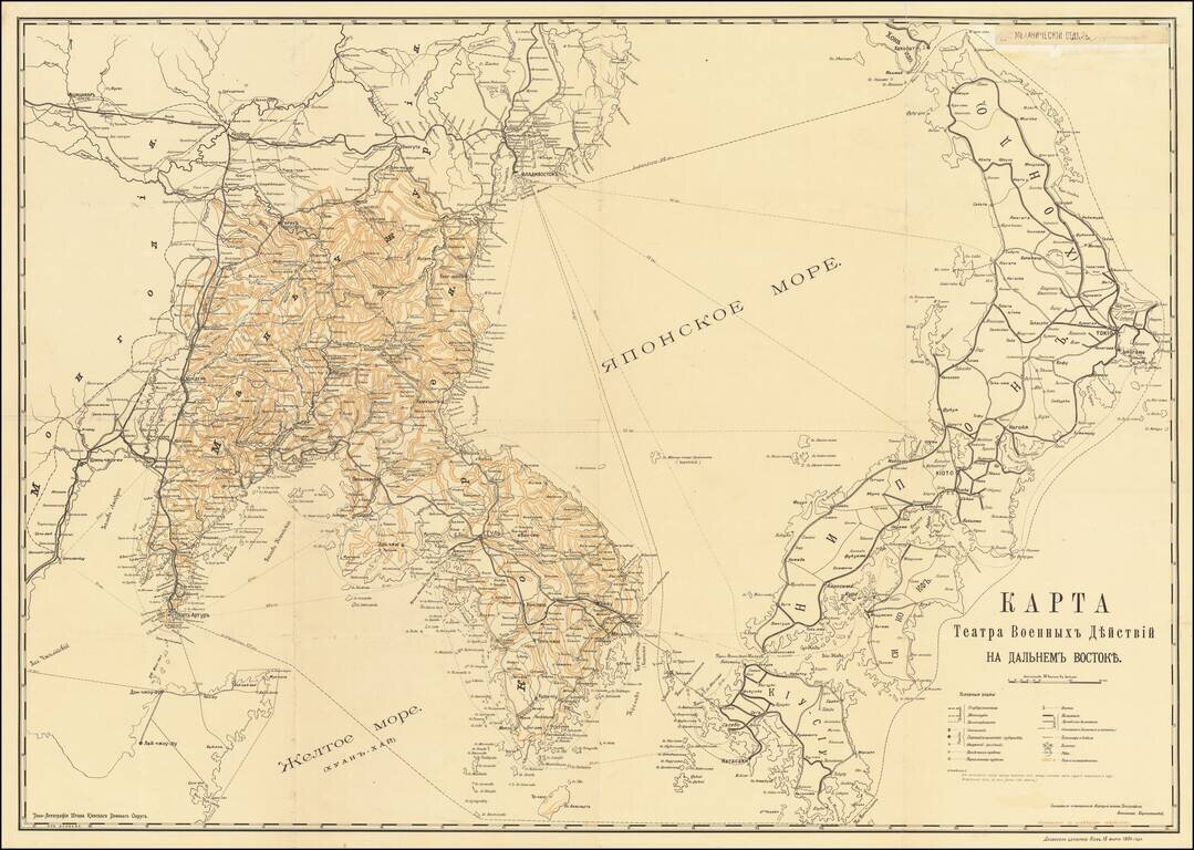
Detailed Russian-language map of the Sea of Japan, Korea, Japan, and Vladivostok, issued during the Russo-Japanese War. The map was compiled and published by the Russian Corps of Topographers, with clearance through the censors in Kiev. The map shows...
![[Illustrated Plan of Moscow & its Environs] Illustrirovannyi Plan
Moskovi i yeye Okrestnostmy.](/map/small/37725.jpg)
A highly decorative and large-scale plan of Moscow, depicting the city not long before the Revolution of 1917. This magnificent map depicts all of Moscow and its environs as it appeared in 1910, during the twilight of the Czarist period. In large...
![[WWI Russian Propagandist Broadside: 'The Air War. - The Feats of Pegu']
Voina v vozdukhe. – Podvig Pegu.](/map/small/37962.jpg)
A Rare Russian World War I Propagandist 'Lubok' broadside, celebrating the feats of French fighter ace Adolphe Célestin Pégoud, printed in Moscow by Ivan Stylin. This amazing Russian WWI broadside shows the French fighter ace Adolphe Célestin...
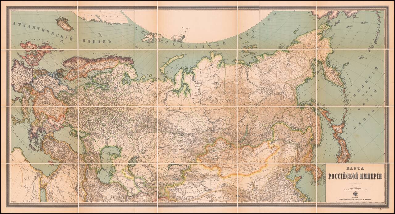
Excellent Russian-language antique map of Russia, published in the last years of the Russian Empire. The map was published by the Alexey Iliyn Cartograph Institute, which was named after one of Imperial Russia's great 19th-century cartographers. The...
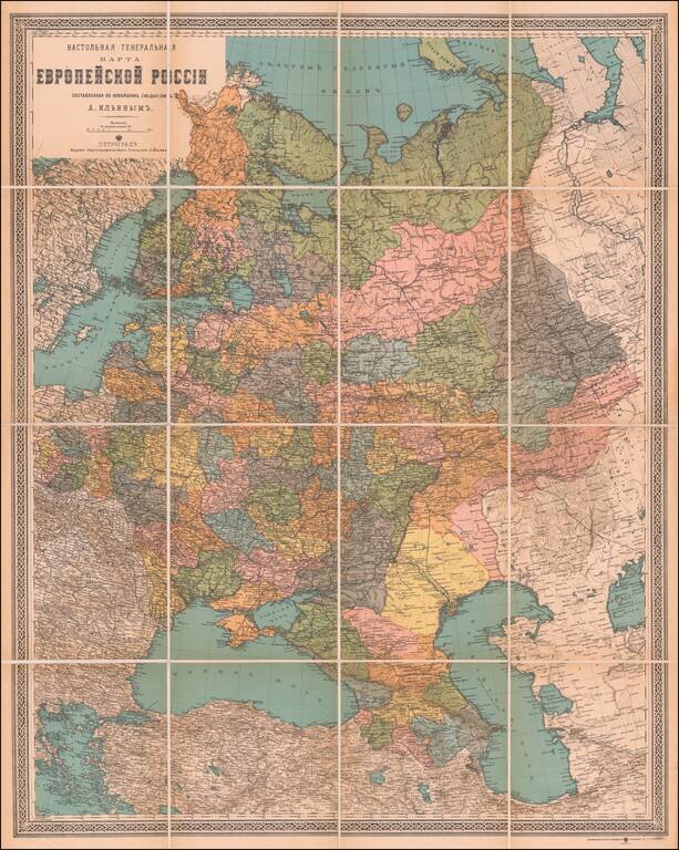
Attractive Russian-Language Map of Russia, from the World War I Era. Antique map of European Russia, published in Petrograd (Saint Petersburg) between 1914 and 1917. The map was published by the Alexey Iliyn Cartograph Institute, which was named...
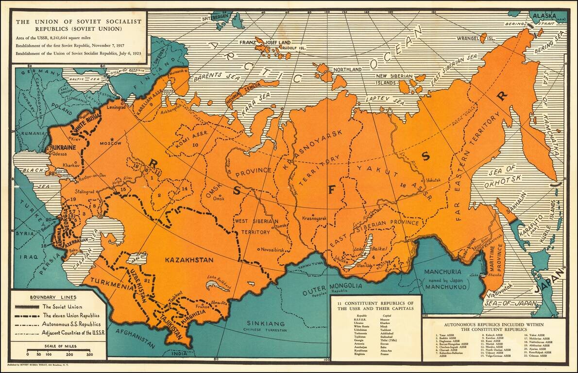
Soviet Russia Today was a pro-Communist magazine first published in February 1932, in New York, by the Friends of the Soviet Union. An interesting political map of the Soviet Union from the time of the Great Purge. The map pre-dates the annexation of...
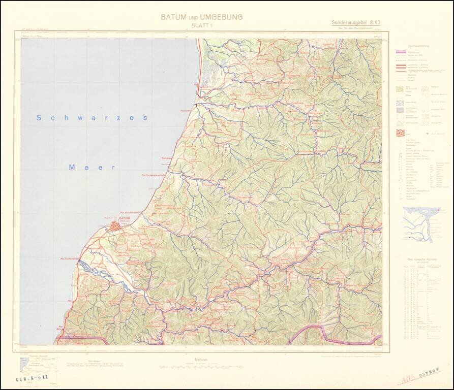
Four-sheet color-printed topographical map of the Adjarian Autonomous Soviet Socialist Republic and neighboring regions, prepared for strategic use by the General Staff of the German Army. The map is based on a 1917 German General Staff map. The area...
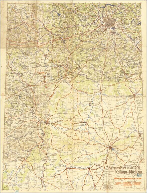
The Scene of the Wehrmacht Defeat Outside Moscow. Rare German plan of military positions and strategic landmarks between Kaluga and Moscow, published on the 8th of October, 1941, during the Battle of Moscow. The map shows the front as it existed in...

Map of the Russian Front Published in the British Empire Fascinating WWII broadside propaganda map, published in India, in order to keep the local populous informed about the War. The map illustrates the Russian Front, from the Caucus Mountains and...
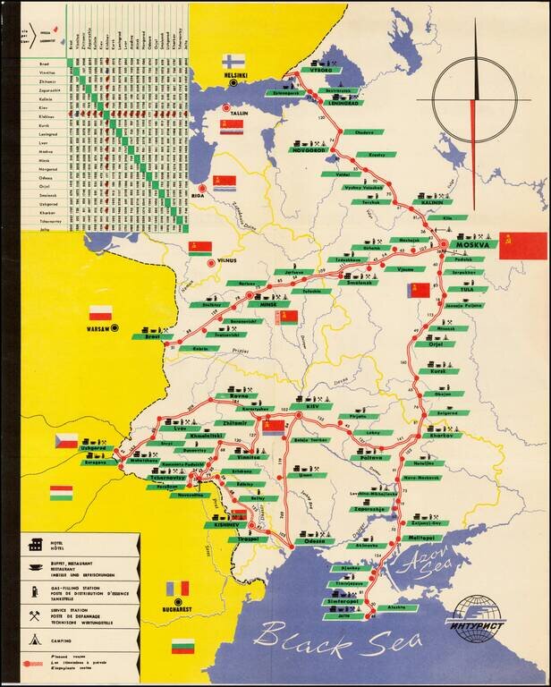
Decorative tourist map of Russia, showing the bus lines throught the country. An interesting Soviet era tourist item.
![[Pictographic Map of Moscow] Moscou.](/map/small/37917.jpg)
An attractive and engaging 1950s pictographic map of Moscow, showing the Soviet capital's main sites during the height of the Cold War. This interesting map provides a rare Western-language pictographic map of Moscow, then the capital of the Soviet...