
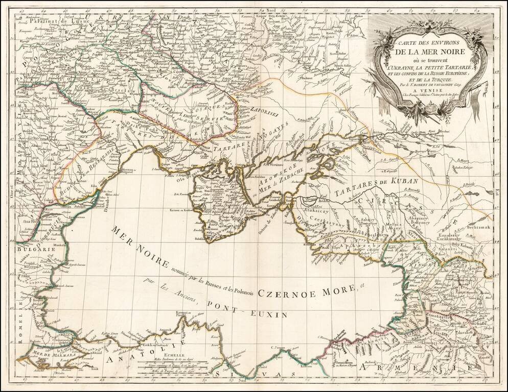
Scarce regional map centered on the Black Sea, published in Venice by Francois Santini. One of the most detailed maps of the region published in the mid-18th century.
![[Map of the Kiev Region] КАРТА КІЕВСКАГО НАМѢСТНИЧЕСТВА](/map/small/57871.jpg)
19th-century photo-lithographed facsimile of a map of the Kiev region from Alexander Wilbrecht's famous 1792 Atlas of the Russian Empire (Российский атлас). Pale of Settlement The map is interesting for many reasons, not least of which...
![КАРТА ВСЕГО АЗОВСКАГО МОРЯ сочинена съ описи, вновь учиненной 1803 года, на компасъ имѣющей склоненіе 8, Западное. Глубииa моряозначена футами. [Map of the Whole Azov Sea...]](/map/small/56511.jpg)
Detailed Map of the Sea of Azov, issued Upon the Creation of the Taurida Governate by Alexander I. Separately issued Russian engraved map of the Sea of Azov, published in 1803, after a period of improved surveying of the body of water. The map far...
![Генеральный Планъ Города Одессы съ Принадлежащею Оному Землею Раздѣленною на 6ть Частей съ показанiемъ Предмѣстiй, селенiй, хуторовъ, садовъ и другихъ Казенныхъ и частныхъ заведенiй. [General Plan of the City of Odessa...]](/map/small/56509.jpg)
One of the Great Ukrainian City Plans. Separately issued, lithographed map of Odessa and environs on two sheets, issued in 1835. The map separates the area into six districts. Plots of land are numbered. Types of land use, roads, and other features...
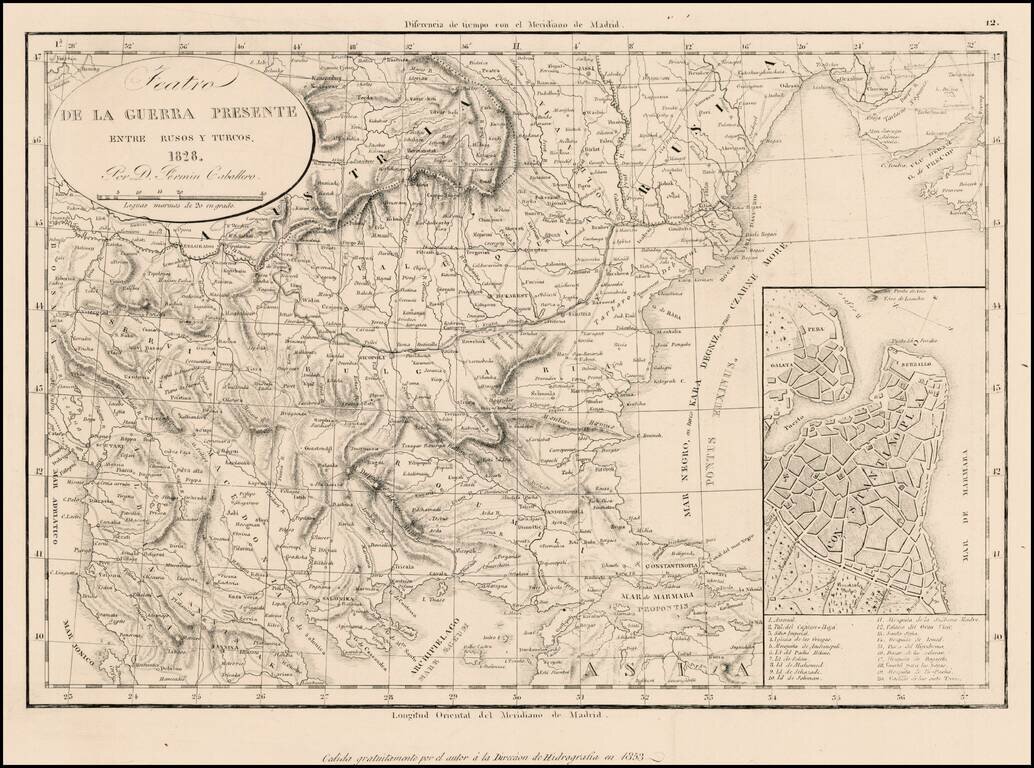
Rare separately issued map illustrating the Theater of War between the Russians and the Ottoman Empire, dated 1828 and issued by the Fermin, with a later imprint for the Direccion Hidrographia. Includes a large inset plan of Istanbul.
![[Odessa] ПЛАНЪ ГОРОДА ОДЕССЫ Составл. Землемѣр. Крыловымъ [Plan of the City of Odessa. Compiled by the Surveyor Krylov.]](/map/small/56510.jpg)
One of the Great Maps of Odessa. A stunning lithographed map of Odessa, Ukraine, published in Odessa in 1864. The map separates Odessa by its constituent neighborhoods and depicts land classifications pictorially. The map has four detailed inset...
![[Bukovina] Harta Etnografica a Bucovinei Intocmita Pe TEmeiul Recenzamantului Oficial Din 1910 De I. Nistor](/map/small/53990.jpg)
Detailed Ethnographic map of Bucovina, identifying the ethnic make up of the cities and towns in the region. An explanation of the color coding is shown at the left, including 8 different ethnic groups, including: Roma Ruthenians (Eastern Slavic...
![[Schematic Plan of the City of Lviv] Схематичний план мiста Львова](/map/small/69855.jpg)
Interesting Ukrainian-language post-World War II map of Lviv, Ukraine. The map is focused on firefighting, with the upper-left corner including an image and slogan entreating people to join the volunteer fire brigade. In the upper-right corner is a...
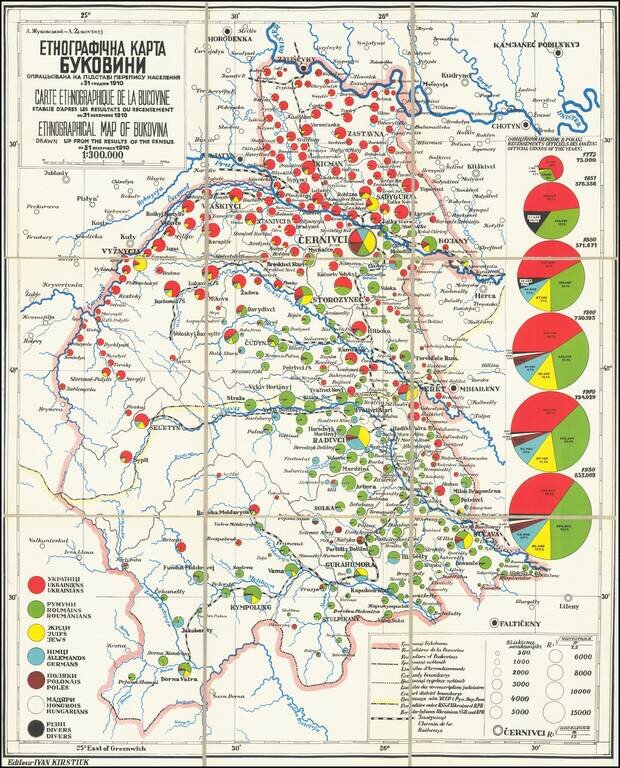
This fascinating map is a rare look into the distributions of various ethnicities through the historical region of Bukovina, prior to the world wars, with insights regarding Jewish history in the region. The map was based on work by the famed Ukrainian...
![[Ukraine Tourist Map - In the Ukrainian Language] Україна Туристська Схема (на украінском языке)](/map/small/66073.jpg)
Rare 1963 Ukrainian-language pictorial tourist map of the Ukrainian Soviet Socialist Republic and the Moldavian Soviet Socialist Republic. Major roads for tourists are noted, as are hotels, restaurants, gas stations, auto repair workshops, and...
![[Kiev Map with City Transport Lines.] КИЇВ КАРТОСХЕМА З ТРАСАМИ МІСЬКОГО ТРАНСПОРТУ](/map/small/55954.jpg)
Ukrainian-language color-printed folding map illustrating the mass transit lines in Kiev. Published in the city in 1965. The map features an inset of the city center in the upper right and a key in the lower left. An extensive list of points of...
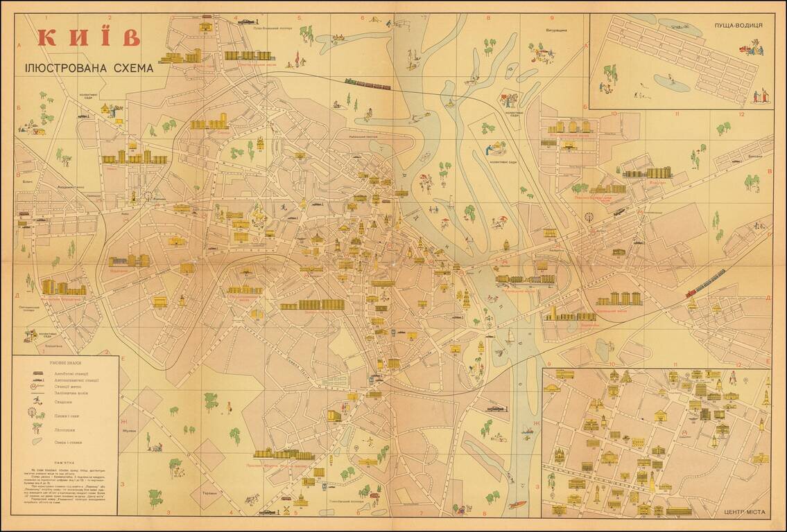
Attractive illustrated Soviet-era map of Kiev, with text in Ukrainian, especially highlighting areas of interest to tourists. The inset at the lower right shows the "ЦЕНТР МІCТА" (Downtown), the inset at upper right shows...
![ОДЕССА (Odessa) - ЦЕНТРАЛЬНАЯ ЧАСТЬ ГОРОДА (Downtown) [Inset]](/map/small/48944.jpg)
Attractive color-printed folding map of Odessa, issued in Moscow as part of a series of tourist maps for medium to large cities in the USSR. Points of interest are shown. Various parks, places for leisure activity, and public transit are all described...
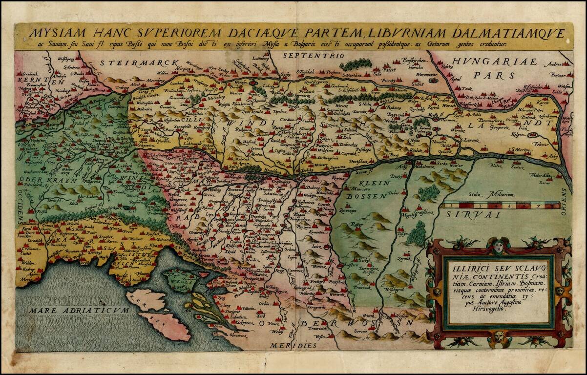
Old color example of De Jode's rare map of the northern Balkans region, including Slovenia, Croatia, Bosnia, Serbia, Istria, and part of Hungary. The map is based upon an earlier map by Augustino Hirsvogelio. De Jode's Speculum Orbis Terrarum was...
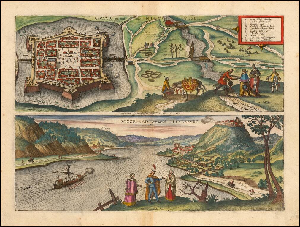
Fine pair of views of the cities of Nové Zámky, Slovakia and Visegrád, Hungary, from Braun & Hogenberg's Civitas Orbis Terrarum. These are among the earliest printed views of each of the two cities.