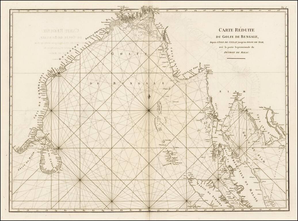
Fine sea chart from Mannevillette's Le Neptune Oriental, first published in 1775. Important early sea chart showing the coastlines of India, Ceylan, Thailand, Malaysia, Sumatra, Cambodia and Vietnam. Jean Baptiste Nicolas Denis D'Apres de...
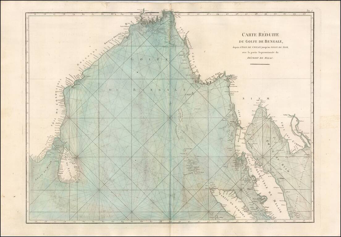
Fine sea chart from Mannevillette's Le Neptune Oriental, first published in 1775. Important early sea chart showing the coastlines of India, Ceylan, Thailand, Malaysia, Sumatra, Cambodia and Vietnam. Jean Baptiste Nicolas Denis D'Apres de...
![[Seychelles] A Chart of the Mahe and Amirantes Islands, with their Shoals by Monsr. le Vicomte Grenier 1776](/map/small/66725.jpg)
The First Commercially Published Map of the Amirantes and Seychelles First state of this rare early sea chart of the Seychelles, published by Robert Sayer in London. The chart covers the Mahe and Amirantes islands, also known as the Three Brothers...
![[Diego Garcia / Chagos Archipelago] Track of the Calcutta East Indiaman, over the Bassas de Chagas, in the Indian Ocean](/map/small/66729.jpg)
Rare separately published sea chart of the Chagos Archipelago, published in London by Sayer. Chagos Archipelago Portuguese explorers were the first Europeans to discover the archipelago. Portuguese navigator Pedro de Mascarenhas (1470 – 23 June...
![[Indian Ocean Currents] Carte du Sisteme des courants des Mers de L'Inde dans le tems de la mousson du N.E. au N. de la Ligne. Publiee par Vicomte Grenier en 1776](/map/small/58646.jpg)
Finely illustrated sea chart of a portion of the Indian Ocean, highlighting the direction of the ocean currents and prevailing winds in the region. Important chart illustrating the fastest sailing routes through the region. The present chart is one...

An 18th Century English Wall Map of Asia, Australia & The Indian Ocean Nice example of the 6 sheet Laurie and Whittle wall map of Asia, Australia and the Indian Ocean, first published in Asia in 1794. The map in its complete state covers an area...
Provides one of the First Accurate Descriptions of Bouvetøya A detailed and fascinating chart of the South Indian Ocean, showing some of the most important journeys of the late 18th and early 19th centuries. This includes Cook's 1776 voyage and du...

Penelope Steel's Map of the Indian Ocean -- Used in an American Circumnavigation in the 1840s. Rare four-sheet blueback sea chart of the Indian and Pacific Oceans, focusing on the trading routes from the east coast of Africa to Canton and New Zealand,...
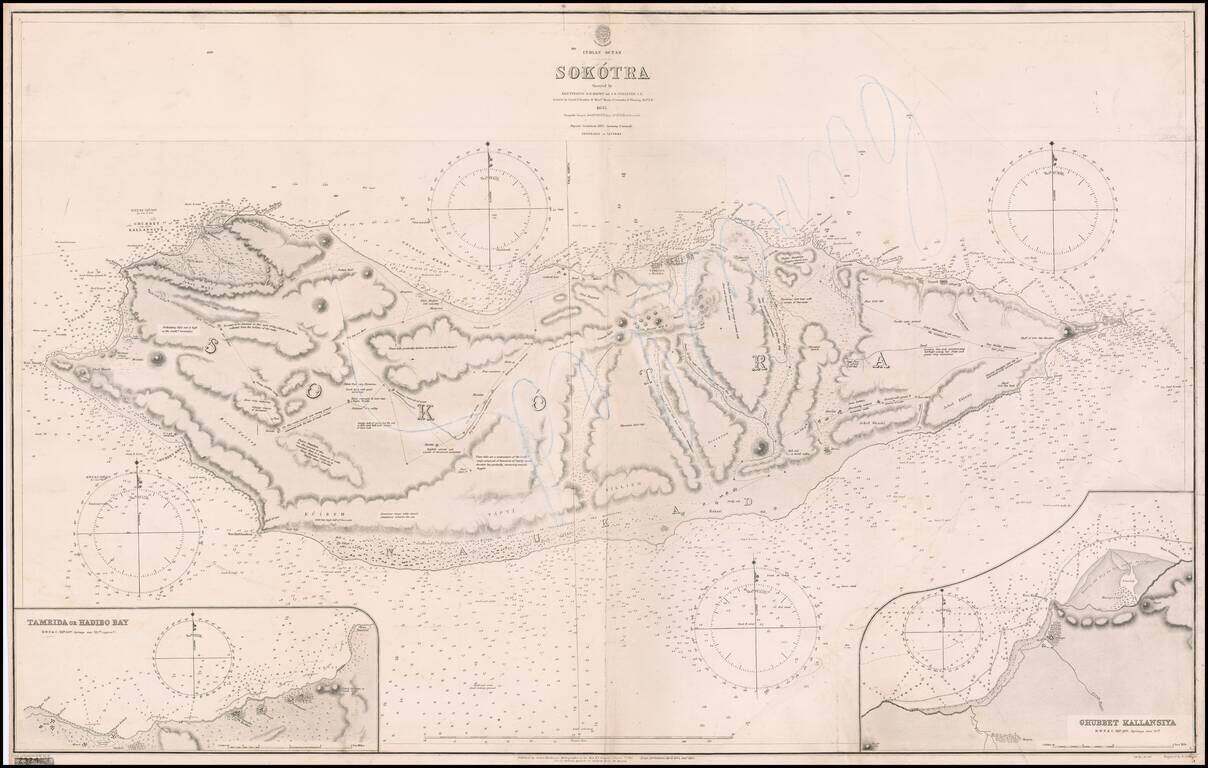
A Rare Early Sea Chart of Socotra Island. Fine large format Socotra Island, published by the British Admiralty, first published in 1857. Includes large insets of Tamrida or Hadibo Bay and Ghubbet Kallansiya Regional History In 1507,Tristão da...
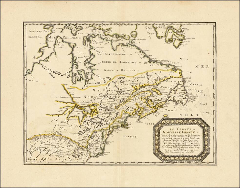
The First Map to Name Lake Erie—A Landmark Map for the Cartography of the Great Lakes and Canada Fine example of Sanson’s seminal map of Canada and the Great Lakes, one of the most important maps of North America from the period of French...
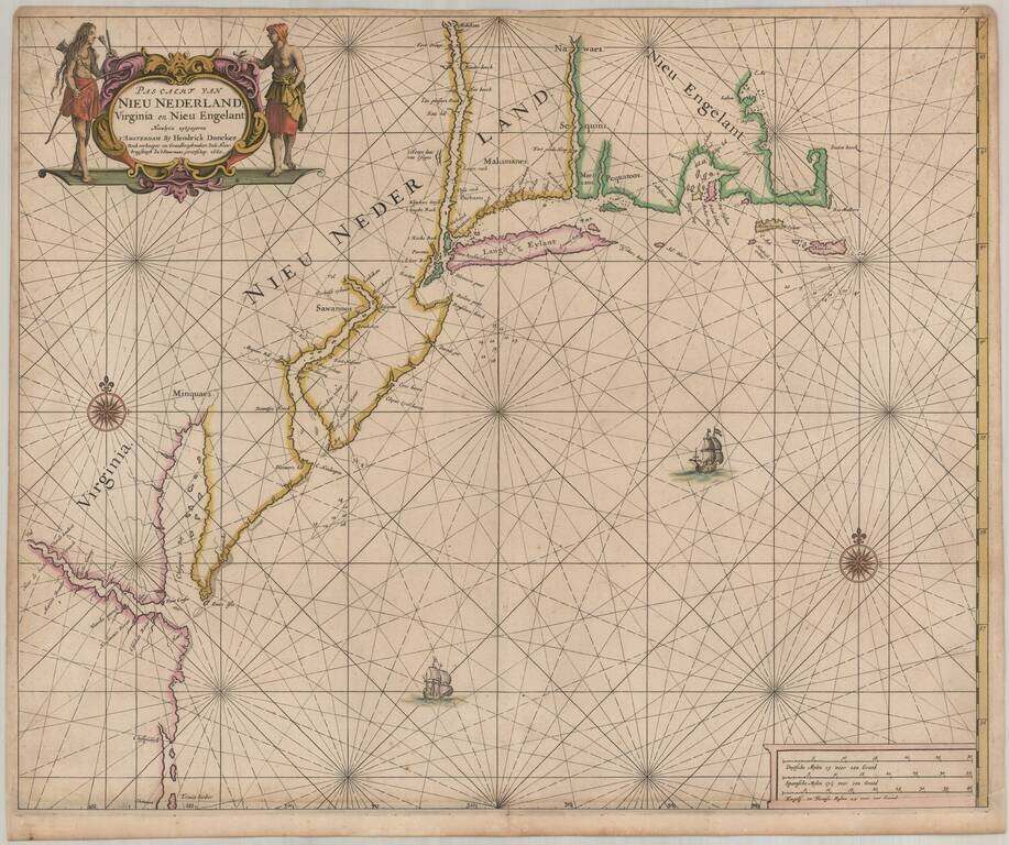
One of the earliest obtainable Sea Charts of the Atlantic Coast of North America. Important early Dutch sea chart of the coast of North America from Trinity Harbor, North Carolina to Cape St. Ann, Massachusetts, from Doncker's Zee-atlas ofte...
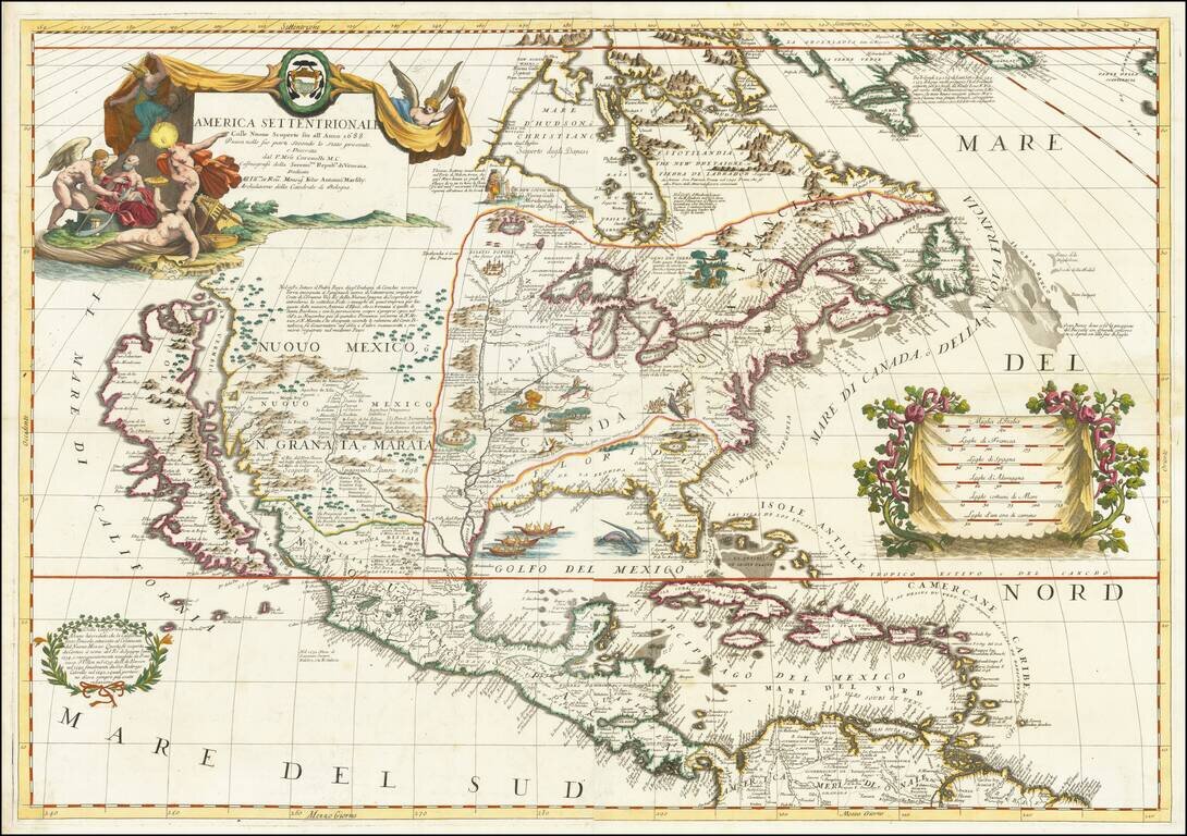
Landmark Map of North America by Coronelli with California as an Island Fine example of Coronelli's cornerstone map of North America, one of the most influential maps of the continent published in the late seventeenth century. The map is...

The First Printed Map Devoted to The Great Lakes and Upper Mississippi Region Nice example of Jean-Baptiste Nolin's landmark map of the Midwest, presenting for the first time on a printed map the evidence of the robust and multi-faceted exploration of...
![Carte Du Mexique et de la Floride des Terres Angloises et des Isles Antilles du Cours et des Environs de la Riviere Mississipi . . . Rue Des Canettes . . . 1703 [1st State]](/map/small/66307op.jpg)
A Cartographic Landmark -- The First Map To Accurately Depict the Course and Mouth of the Mississippi River Rare first state of the first printed map to accurately depict the course and mouth of the Mississippi River, published by Guillaume De L'Isle...
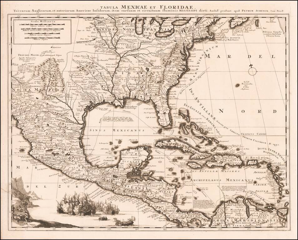
Antique Map of The Future United States and the Spanish Main -- Important Early Depiction of the Mississippi River and the Great Lakes Fine example of Schenk's decorative map of the Southeastern part of North America, Gulf Coast and the Spanish Main,...
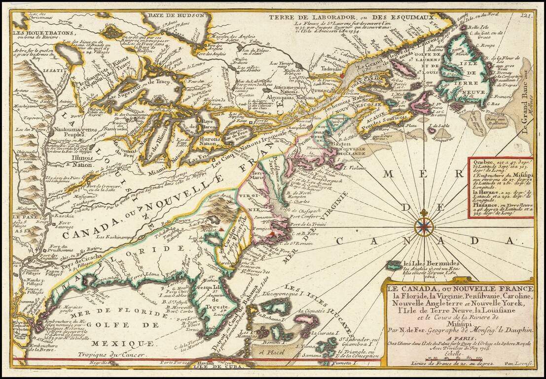
Antique 18th century map of the Eastern United States and Canada, from De Fer's Atlas Curieux. A map which illustrates the extent of French royal control over the North American Continent. Canada, also named Nouvelle France on the map, extends from...