Abraham Ortelius is perhaps the best known and most frequently collected of all sixteenth-century mapmakers. Ortelius started his career as a map engraver. In 1547 he entered the Antwerp guild of St Luke as afsetter van Karten. His early career was as a business man, and most of his journeys before 1560 were for commercial purposes. In 1560, while traveling with Gerard Mercator to Trier, Lorraine, and Poitiers, he seems to have been attracted, largely by Mercator’s influence, towards a career as a scientific geographer. From that point forward, he devoted himself to the compilation his Theatrum Orbis Terrarum (Theatre of the World), which would become the first modern atlas.
In 1564 he completed his “mappemonde", an eight-sheet map of the world. The only extant copy of this great map is in the library of the University of Basle. Ortelius also published a map of Egypt in 1565, a plan of Brittenburg Castle on the coast of the Netherlands, and a map of Asia, prior to 1570.
On May 20, 1570, Ortelius’ Theatrum Orbis Terrarum first appeared in an edition of 53 maps. By the time of his death in 1598, a total of 25 editions were published including editions in Latin, Italian, German, French, and Dutch. Later editions would also be issued in Spanish and English by Ortelius’ successors, Vrients and Plantin, the former adding a number of maps to the atlas, the final edition of which was issued in 1612. Most of the maps in Ortelius Theatrum were drawn from the works of a number of other mapmakers from around the world; a list of 87 authors is given by Ortelius himself
In 1573, Ortelius published seventeen supplementary maps under the title of Additamentum Theatri Orbis Terrarum. In 1575 he was appointed geographer to the king of Spain, Philip II, on the recommendation of Arias Montanus, who vouched for his orthodoxy (his family, as early as 1535, had fallen under suspicion of Protestantism). In 1578 he laid the basis of a critical treatment of ancient geography with his Synonymia geographica (issued by the Plantin press at Antwerp and republished as Thesaurus geographicus in 1596). In 1584 he issued his Nomenclator Ptolemaicus, a Parergon (a series of maps illustrating ancient history, sacred and secular.) Late in life, he also aided Welser in his edition of the Peutinger Table in 1598.
![Insularum Aliquot Maris Mediterranei Descriptio [Sicily, Malta, Sardinia, Corfu, Elba and Zerbia]](/map/small/45115.jpg)
Fine example of Ortelius' maps of the islands of Sicily, Malta, Sardinia, Corfu, Elba and Zerbia, from the Ortelius' Theatrum Orbis Terrarum, the first modern Atlas of the World. Includes a number of sailing ships, including a sinking vessel off...
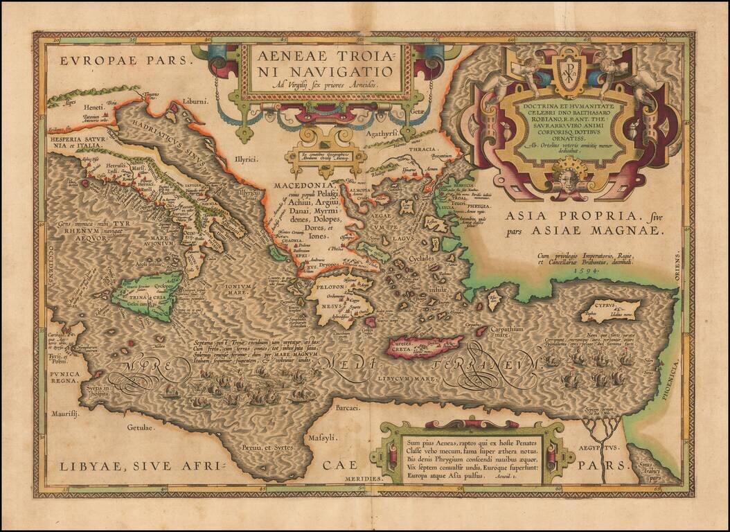
On the Trail of Aeneas, the Trojan—Historical Map of the Mediterranean Sea Chronicling the Story of the Aeneid A finely-detailed map of the eastern Mediterranean Sea, published in Ortelius’ Parergon, his historical atlas of the ancient world. The...
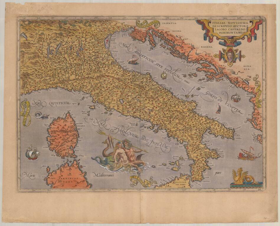
Ortelius's Second Map of Italy Decorative map of Italy from Ortelius' Theatrum Orbis Terrarum, the first modern Atlas of the World. In 1584, Ortelius revised his map of Italy. The changes are primarily aesthetic, with more elaborate script lettering...
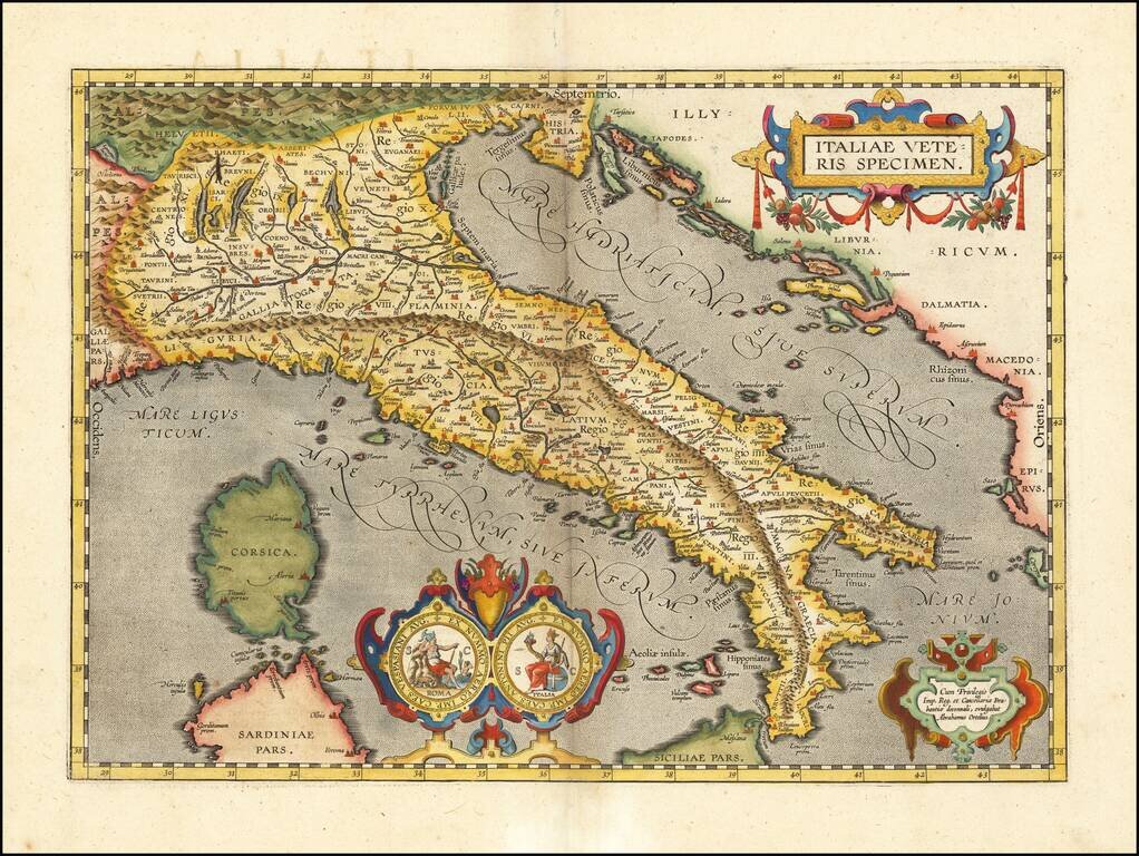
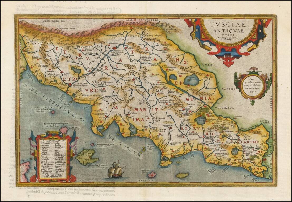
Nice example of Ortelius' map of ancient Italy, from Ortelius' Theatrum Orbis Terrarum, the first modern world atlas. The map is based upon Gastaldi's map of Italy, supplemented with classical sources. Beginning in 1601, a second state of the map was...
![[Padua & Puglia] Patavini Territorii Corographia Iac. Castaldo Auct. [and] Apuliae Quae Olim Iapygia Nova Corographia](/map/small/70702mp2.jpg)
Nice full color example of Ortelius' maps of the region centered on Venice, Padua and Vicenza, in one map and Puglia and Calabria in the other, from his Theatrum Orbis Terrarum, the first modern atlas of the world. Sailing ship and sea monster.
![(Siena, Corsica, etc.) Senensis Ditionis Accurata Descrip [and] Corsica [and] Marcha Anconae Olim Picenum. 1572](/map/small/44502.jpg)
Fine old color example of Ortelius' maps of Corsica, part of Tuscany and the Tuscan Sea (Siena, etc.) and the Ancona region, Ortelius' Theatrum Orbis Terrarum, the first modern atlas of the world.
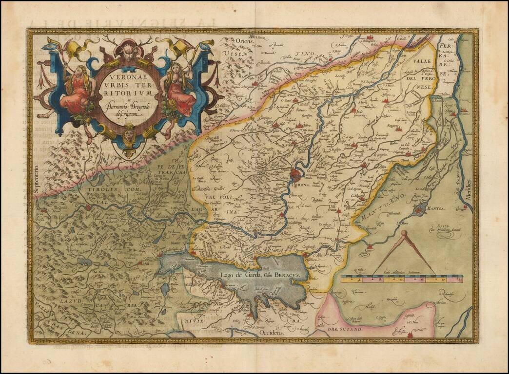
Decorative example of the Ortelius' map of Verona, based upon Brugnoli's map, which was issued by Forlani in Venice in 1574. The map appeared in Ortelius' Theatrum Orbis Terrarum, the first modern atlas of the world. Striking massive cartouche and...
Fine early map of the Etruscan regions of Italy, centered on Florence and the Arno River, which first appeared in 1584, and was revised in a second plate (the present example) starting in 1595. A number of islands shown off the coast. Includes a...
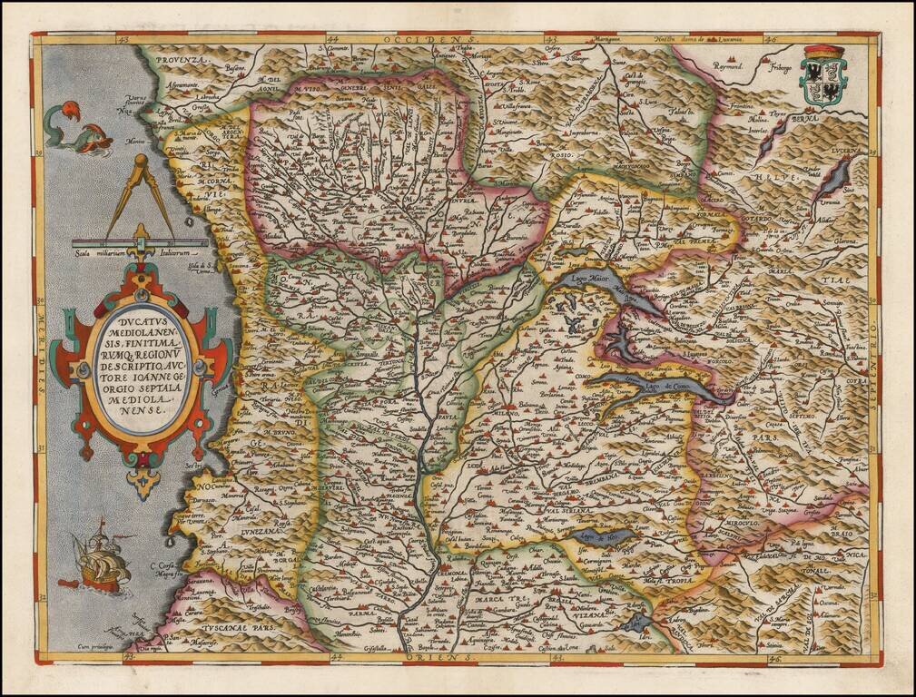
Gorgeous regional map of Italy, centered on Genoa, Lago Maior and Lago Como, and including Milan, Parma, Cremona, Bergamo, Nice, Monaco, etc. Includes a decorative cartouche, sailing ship, sea monster and coat of arms. From Ortelius' Theatrum Orbis...
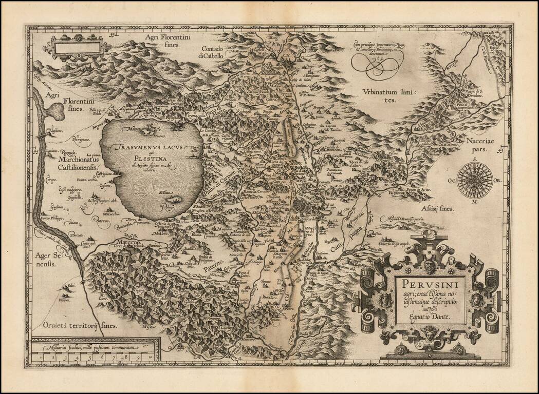
First state of Ortelius' decorative regional map of Italy, centered on Perugia, from Ortelius' Theatrum Orbis Terrarum, the first modern atlas of the world. The map is based upon Egnatio Danti's 1580 Perugia map, engraved by Mario Cartaro (Meurer p....
![Larii Lacus Vulgo Comensis Descriptio . . . [and] Terretorii Romani Descrip. [and] Fori Iulii Vulgo Frivli Typus](/map/small/64715.jpg)
Nice full color example of Ortelius' maps of Lake Como, the region around Rome and the region around the Upper Adriatic, centered on Udinese, from his Theatrum Orbis Terrarum, the first modern atlas of the world. A nice full color example with wide...
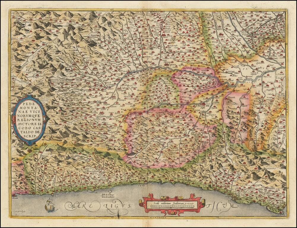
Finely colored example of this detailed map of the Piedmont region, from Santa Margarita, Genoa and Monaco to Milan, centered on Turin, from Ortelius' Theatrum Orbis Terrarum, the first modern atlas of the world. Two cartouches and ship at sea.
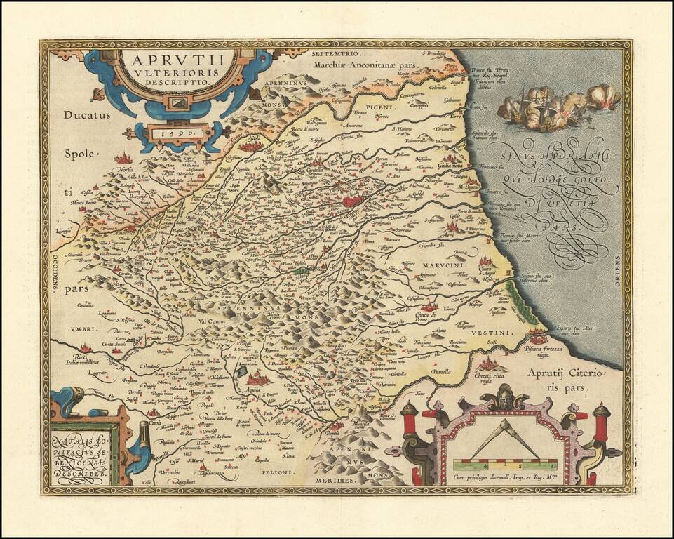
A nice example of Ortelius' map of Abruzzo, published in his Theatrum Orbis Terrarum, the first modern atlas of the World. The map was first issued in 1590 and includes Ascoli, Civitella, Teramo, Aquila and Pescara.
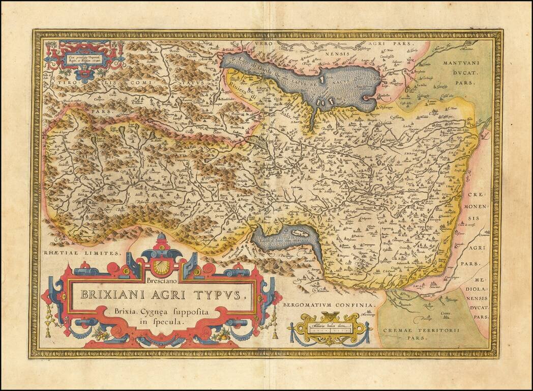
Detailed regional map of northern Italy from Ortelius' Theatrum Orbis Terrarum, the first modern atlas of the world. The map is oriented with east at the top and shows Lago Di Garda, Brescia, Lago d'Iseo, Lago de Idro, etc. Strong dark impression...
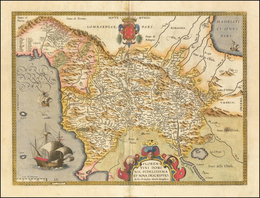
Finely colored example of this scarce map of the Province of Florence in Tuscany, issued in the Vrients editions of Ortelius' Theatrum Orbis Terrarum. The map is centered on the city of Florence and extends to Liguria, the Apennine Mountains, the...
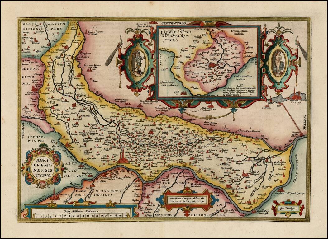
Nice full color example of Ortelius' map of the region centered on Cremona and the Padus River, with a large inset, from Oretlius's Theatrum Orbis Terrarum, the first modern atlas of the world. Extends to Mantua and Piacenza. Several ornate...