Abraham Ortelius is perhaps the best known and most frequently collected of all sixteenth-century mapmakers. Ortelius started his career as a map engraver. In 1547 he entered the Antwerp guild of St Luke as afsetter van Karten. His early career was as a business man, and most of his journeys before 1560 were for commercial purposes. In 1560, while traveling with Gerard Mercator to Trier, Lorraine, and Poitiers, he seems to have been attracted, largely by Mercator’s influence, towards a career as a scientific geographer. From that point forward, he devoted himself to the compilation his Theatrum Orbis Terrarum (Theatre of the World), which would become the first modern atlas.
In 1564 he completed his “mappemonde", an eight-sheet map of the world. The only extant copy of this great map is in the library of the University of Basle. Ortelius also published a map of Egypt in 1565, a plan of Brittenburg Castle on the coast of the Netherlands, and a map of Asia, prior to 1570.
On May 20, 1570, Ortelius’ Theatrum Orbis Terrarum first appeared in an edition of 53 maps. By the time of his death in 1598, a total of 25 editions were published including editions in Latin, Italian, German, French, and Dutch. Later editions would also be issued in Spanish and English by Ortelius’ successors, Vrients and Plantin, the former adding a number of maps to the atlas, the final edition of which was issued in 1612. Most of the maps in Ortelius Theatrum were drawn from the works of a number of other mapmakers from around the world; a list of 87 authors is given by Ortelius himself
In 1573, Ortelius published seventeen supplementary maps under the title of Additamentum Theatri Orbis Terrarum. In 1575 he was appointed geographer to the king of Spain, Philip II, on the recommendation of Arias Montanus, who vouched for his orthodoxy (his family, as early as 1535, had fallen under suspicion of Protestantism). In 1578 he laid the basis of a critical treatment of ancient geography with his Synonymia geographica (issued by the Plantin press at Antwerp and republished as Thesaurus geographicus in 1596). In 1584 he issued his Nomenclator Ptolemaicus, a Parergon (a series of maps illustrating ancient history, sacred and secular.) Late in life, he also aided Welser in his edition of the Peutinger Table in 1598.
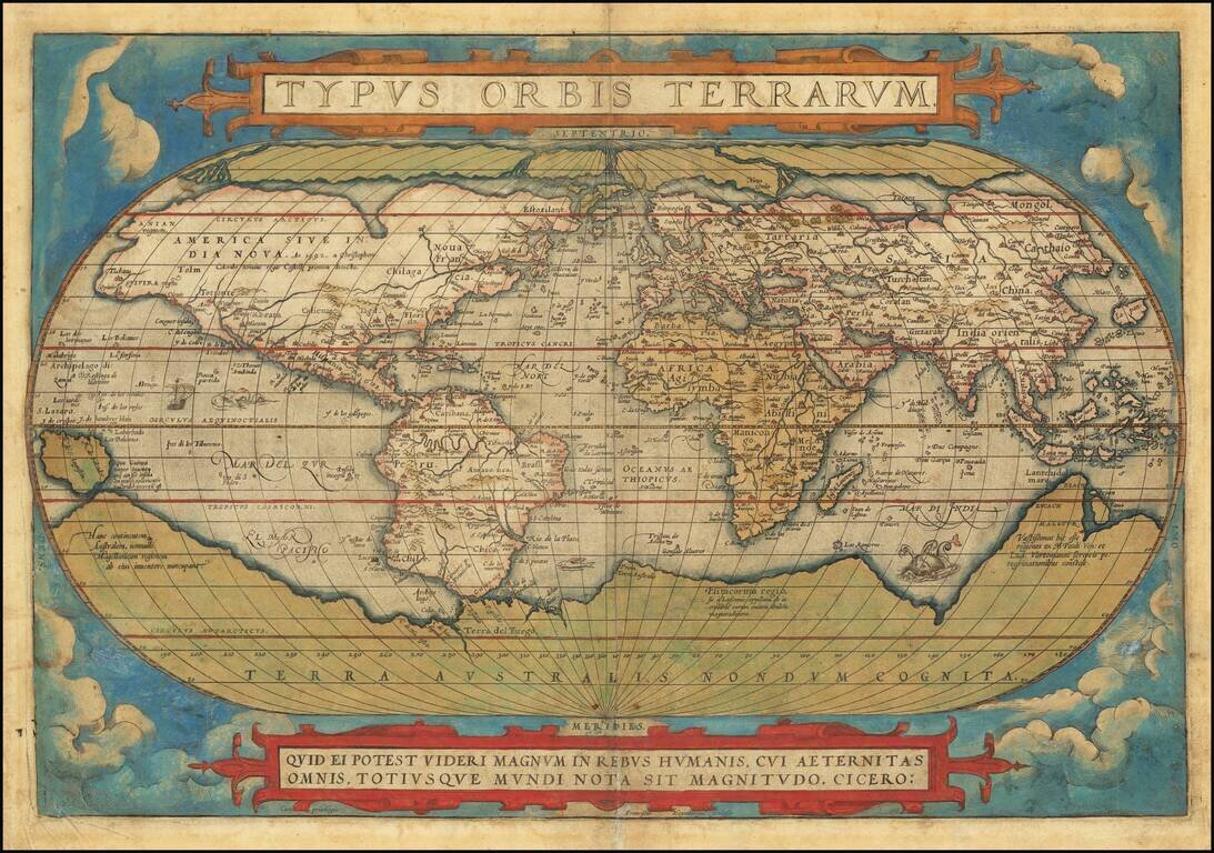
Old color example of the first edition of Ortelius' famous world map. Ortelius' world map is one of the most important and widely disseminated maps of the second half of the 16th Century, forming the base model for a number of other contemporary maps....
![Typus Orbis Terrarum [Rare 2nd Edition, 2nd State]](/map/small/71277.jpg)
Rare Second Plate -- Ortelius' Landmark World Map Nice old color example of one of the most famous world maps ever made, "Typus Orbis Terrarum" featured in the world's first atlas, Theatrum Orbis Terrarum. Abraham Ortelius (1527-1598) included the...
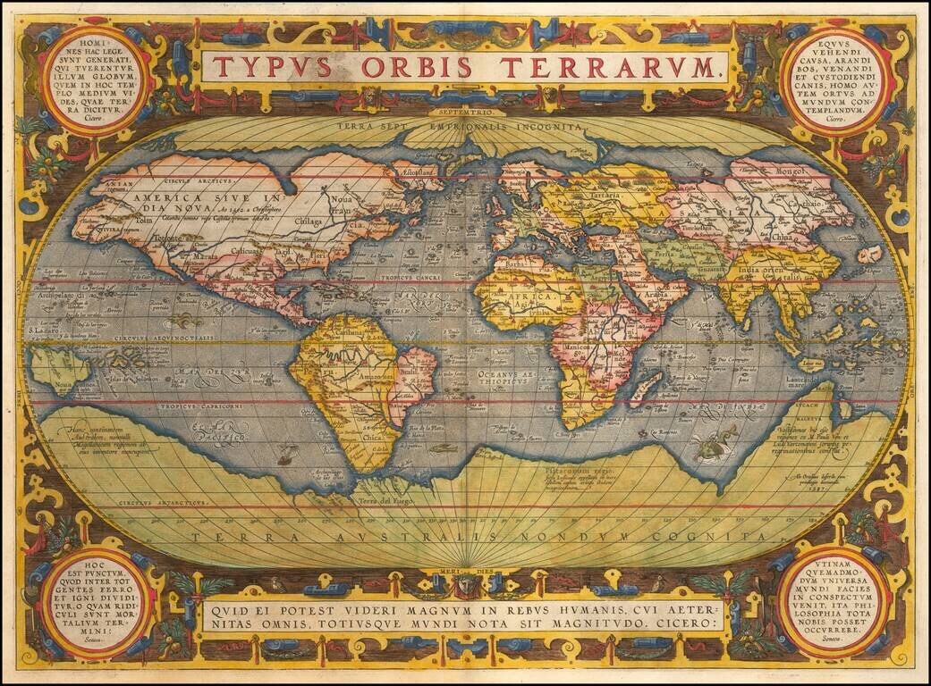
Striking Example of Ortelius' Landmark World Map One of the most famous world maps ever made, Ortelius’s “Typus Orbis Terrarum” featured in the world’s first modern atlas. This is the third edition of the map, which first appeared in 1589 and...
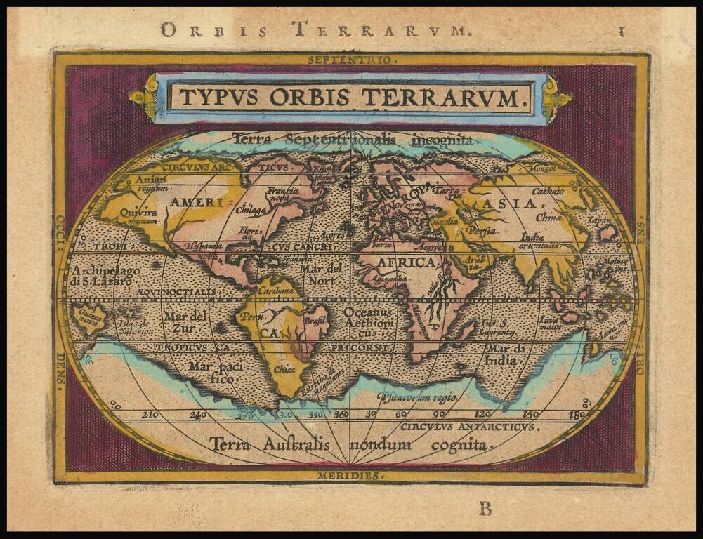
Finely engraved example of the oval world map from and early edition of Ortelius Epitome published by Giovanni Battista Vrients. The map follows the geographical features of Ortelius' 1584 map of the World, including the corrected shape of South...
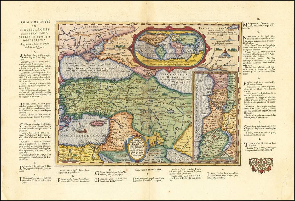
Historical map of the Ancient World, based upon the Bible, published in the last Moretus edition of the Parergon in 1624. The map shows the pyramids in Egypt, the route of Abraham from Ur to Sichem, and the wandering of the Children of Israel. In the...
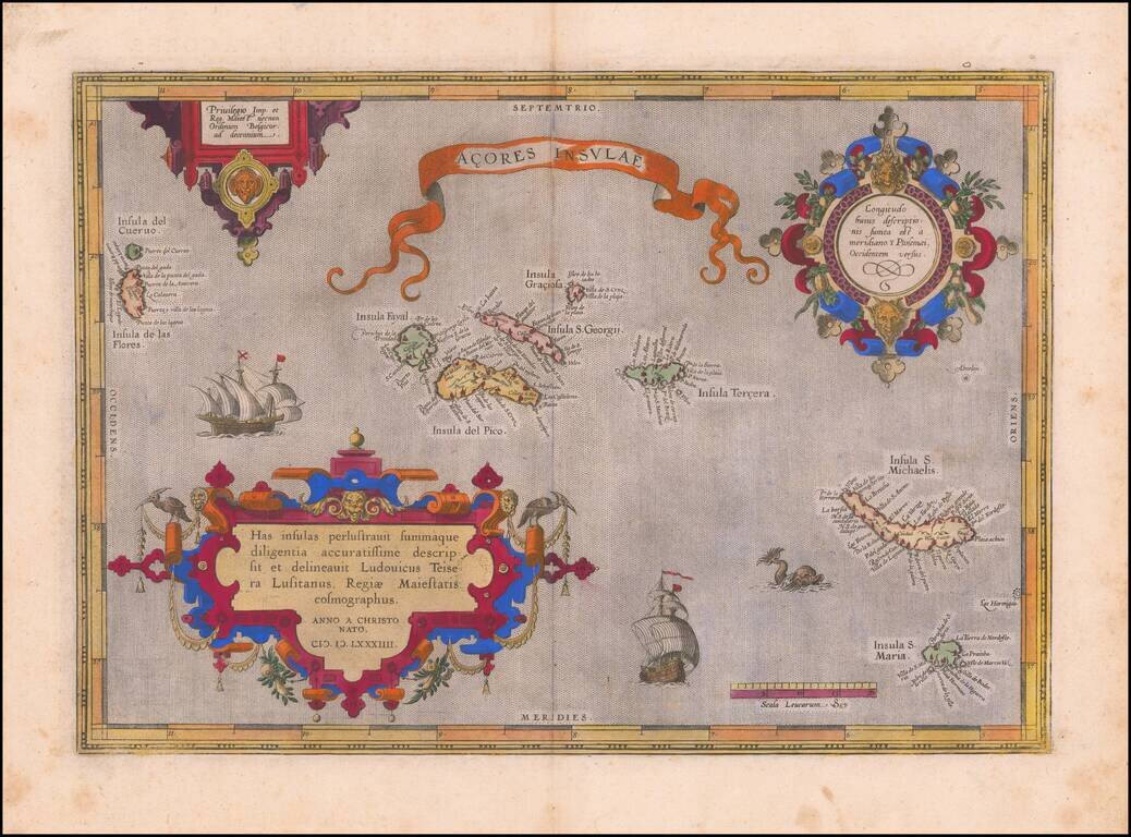
Old color example of Ortelius' map of the Azores, one of the most important destinations of explorers and early commercial mariners in the 16th Century. The size and detail of the map reflects the strategic importance of the Azores during the 16th...

Fine old color example of Ortelius' map of the Azores, one of the most important destinations of explorers and early commercial mariners in the 16th Century. The size and detail of the map reflects the strategic importance of the Azores during the 16th...

Ortelius' Map of the North Atlantic Old color example of Abraham Ortelius's important early map of the North Atlantic, extending from Scandinavia and the Polar regions in the East, to the mythical Islands of the North Atlantic, Greenland, Iceland and...
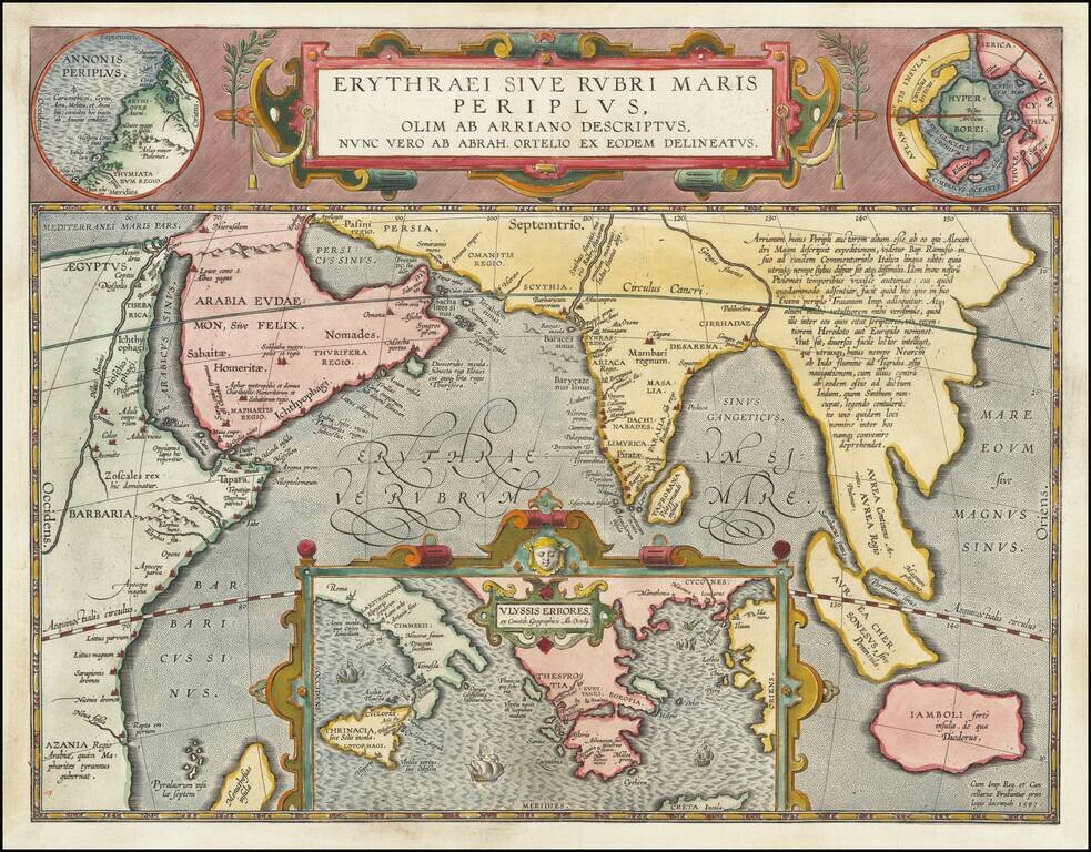
Fine Ortelius Map of the Indian Ocean Linking Mythical, Ancient, and Contemporary Exploration Striking historical map of the Indian Ocean and contiguous regions of the Middle East, India and Southeast Asia, published by Ortelius in his Parergon. This...
![La Florida [with] Guastecan [with] Peruviae Auriferae Regionis Typus](/map/small/61587.jpg)
Ortelius’ Map of Florida—The First Separately Printed Map of Florida! An excellent example of Abraham Ortelius’ seminal map of Florida and the North American South, shown within a trio arrangement of maps focused on Central and South America....
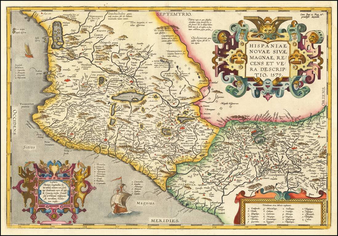
Ortelius' Map of Mexico, One of the Earliest Printed Maps of New Spain Nice example of Ortelius' map of western New Spain, showing the recently-created Spanish settlements, many rivers, and large lakes, including Lake Chapala and a mythical sea with...
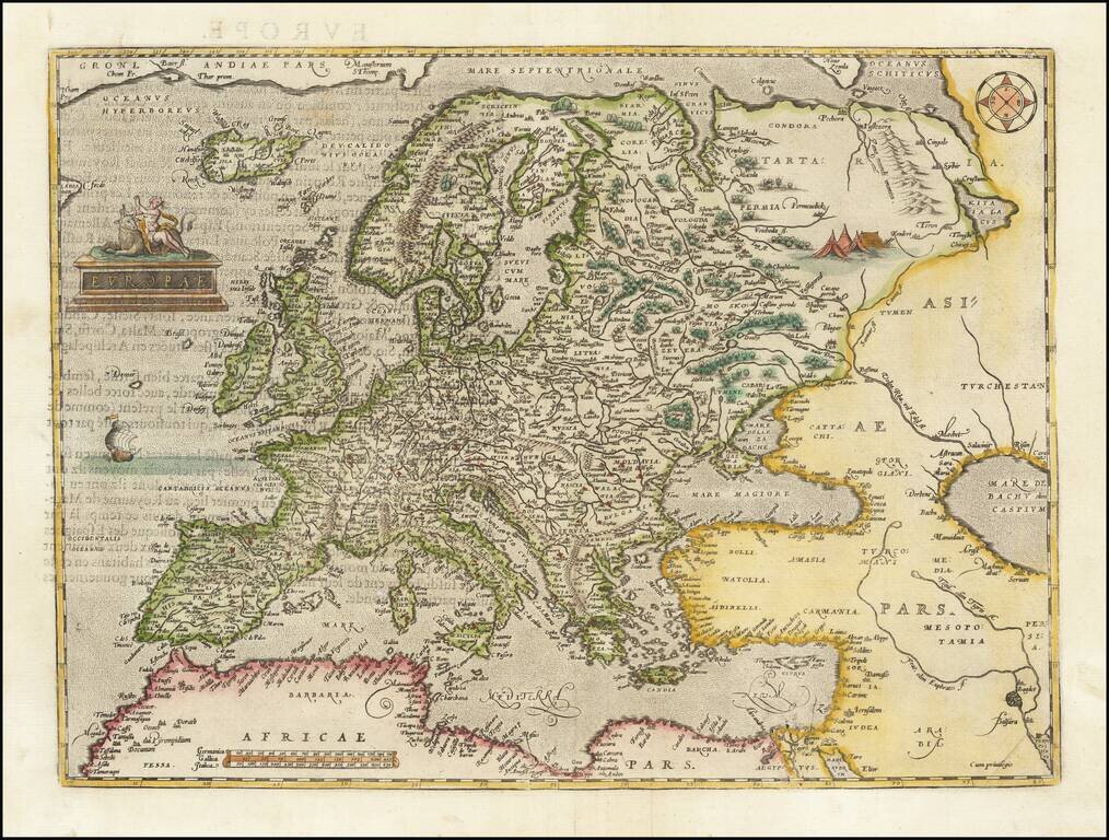
Nice example of Ortelius' first map of Europe. The first edition includes the incorrectly named "Cap de S Tincente" in southwestern Spain, which briefly appeared beginning in 1573, until it was revised to "Cap. de S. Vicente" with the issuance of...

Old color map of the Roman Empire from Abraham Ortelius' Theatrum Orbis Terrarum, the first modern atlas of the world. Several decorative cartouches, 2 portraits, sailing ship and a historical tree showing details.
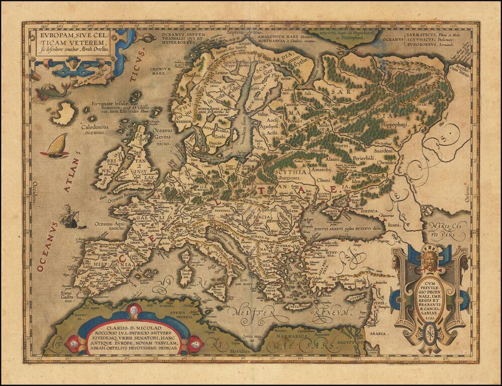
Celtic Europe Striking example of Ortelius' map of the Celtic Empire, from Ortelius' Theatrum Orbis Terraum, first published in 1570. This map first appeared in the 1595 edition of the atlas, and is believed to be derived from Ortelius' 2 sheet map...
![[English Edition!] Angliae et Hiberniae Accurata Descriptio Veteribus et Recentioribus Nominbus Illustratus Et Ad D. Guilel. Camden Britaniam Accomodata . . .](/map/small/63757.jpg)
English Edition of Vrients Map of the British Isles Old color example of Vrients map of the British Isles, which appeared first appeared in the 1606 (English) edition of Ortelius' Theatrum Orbis Terrarum, the first modern atlas of the World Vrients...
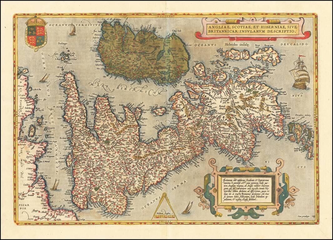
Attractive full-color example of Ortelius' first map of the British Isles, from Ortelius' Theatrum Orbis Terrarum, the first modern atlas of the world. The map is based on Mercator's 1564 map of the British Isles. West is at the top. Includes a number...