Abraham Ortelius is perhaps the best known and most frequently collected of all sixteenth-century mapmakers. Ortelius started his career as a map engraver. In 1547 he entered the Antwerp guild of St Luke as afsetter van Karten. His early career was as a business man, and most of his journeys before 1560 were for commercial purposes. In 1560, while traveling with Gerard Mercator to Trier, Lorraine, and Poitiers, he seems to have been attracted, largely by Mercator’s influence, towards a career as a scientific geographer. From that point forward, he devoted himself to the compilation his Theatrum Orbis Terrarum (Theatre of the World), which would become the first modern atlas.
In 1564 he completed his “mappemonde", an eight-sheet map of the world. The only extant copy of this great map is in the library of the University of Basle. Ortelius also published a map of Egypt in 1565, a plan of Brittenburg Castle on the coast of the Netherlands, and a map of Asia, prior to 1570.
On May 20, 1570, Ortelius’ Theatrum Orbis Terrarum first appeared in an edition of 53 maps. By the time of his death in 1598, a total of 25 editions were published including editions in Latin, Italian, German, French, and Dutch. Later editions would also be issued in Spanish and English by Ortelius’ successors, Vrients and Plantin, the former adding a number of maps to the atlas, the final edition of which was issued in 1612. Most of the maps in Ortelius Theatrum were drawn from the works of a number of other mapmakers from around the world; a list of 87 authors is given by Ortelius himself
In 1573, Ortelius published seventeen supplementary maps under the title of Additamentum Theatri Orbis Terrarum. In 1575 he was appointed geographer to the king of Spain, Philip II, on the recommendation of Arias Montanus, who vouched for his orthodoxy (his family, as early as 1535, had fallen under suspicion of Protestantism). In 1578 he laid the basis of a critical treatment of ancient geography with his Synonymia geographica (issued by the Plantin press at Antwerp and republished as Thesaurus geographicus in 1596). In 1584 he issued his Nomenclator Ptolemaicus, a Parergon (a series of maps illustrating ancient history, sacred and secular.) Late in life, he also aided Welser in his edition of the Peutinger Table in 1598.
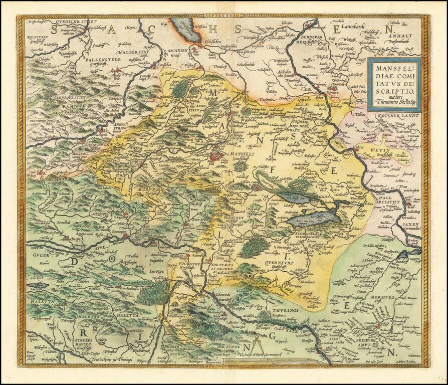
Nice old color example of Ortelius' regional map of Germany, centered on Mansfield and showing the Salsa River from Bernburgh to Rockendorf, and the Helm River, from Berga to Dorndorff. From Ortelius' Theatrum Orbis Terrarum, the first modern atlas of...

Nice old color example of Ortelius' regional map of Germany, showing the Fuld region, with decorative cartouche, compass rose, etc. From Ortelius' Theatrum Orbis Terrarum, the first modern atlas of the World. Half of two sheet map.
![Pomeraniae, Wandalicae Regionis Typ [with] Livoniae Nova Descriptio [with] Ducatus Oswieczensis, et Zatoriensis, Descriptio](/map/small/43172.jpg)
Finely colored example of Ortelius' maps of Pomerania, Latvia and part of Southern Poland above the Carpathian Mountains, from Ortelius Theatrum Orbis Terrarum.
![Hassiae Descriptio . . . [with] Holsatiae Descrip.](/map/small/46478.jpg)
Nice pair of regional maps of Germany, including decorative cartouches, etc. The Hassiae map extends to the Rhine and shows Frankfurt, and extends up to the Werra and Fulda Rivers. The Holsatiae map extends from Hamburg and Louwenburg in the south to...
![Thietmarsiae, Holsaticae Regionis Partis Typus Auctore Petro Boeckel [with] Prussia Descriptio ante aliquot annos ab Henrico Zellio ab coque D. Ioanni Clur. civi Gedanesi Ded:](/map/small/45904.jpg)
Ortelius’ Maps of Prussia and Holstein, from the First Modern Atlas Fine maps of Prussia and Holstein, printed on the same plate, that featured in Ortelius’ famous and groundbreaking atlas Theatrum Orbis Terrarum. The map on the right shows...
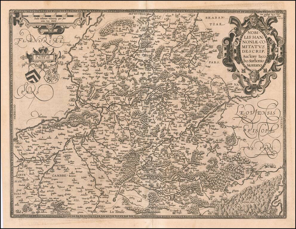
Striking example of Ortelius' map of Hannonia (Hainaut), with ornate cartouches, two coats of arms, etc. Includes the cities of Charleroi, Mons, Ath, Tournay, Valenciennes, Maubeuge, etc. Nice dark impression and wide margins.
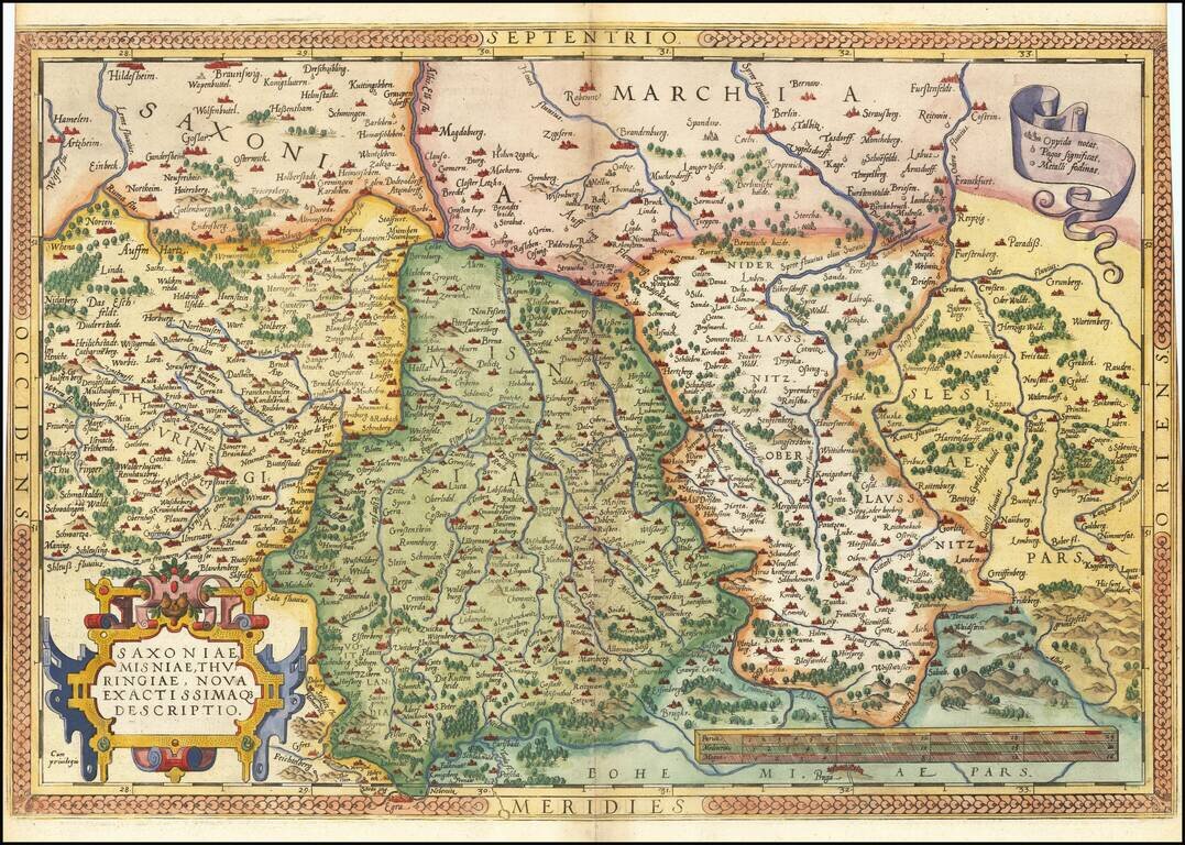
Nice example of Ortelius' regional map of Germany, extending from Prague to Berlin and Brandenberg, and from Mulhausen and Erpach to Goltberg, Sagan, Furstenberg, Leipzig and Frankfurt am Oder. Wide margins and nice old color. From the 1581 French...
![Daniae Regni Typus [with] Oldenburg Comit.](/map/small/49941.jpg)
A nice full-color example of Ortelius' maps of Denmark and Oldenburg, which first appeared in the 1584 edition of his Theatrum Orbis Terrarum. This is the second of Ortelius' maps of Denmark. It shows many more details within Denmark and was improved...
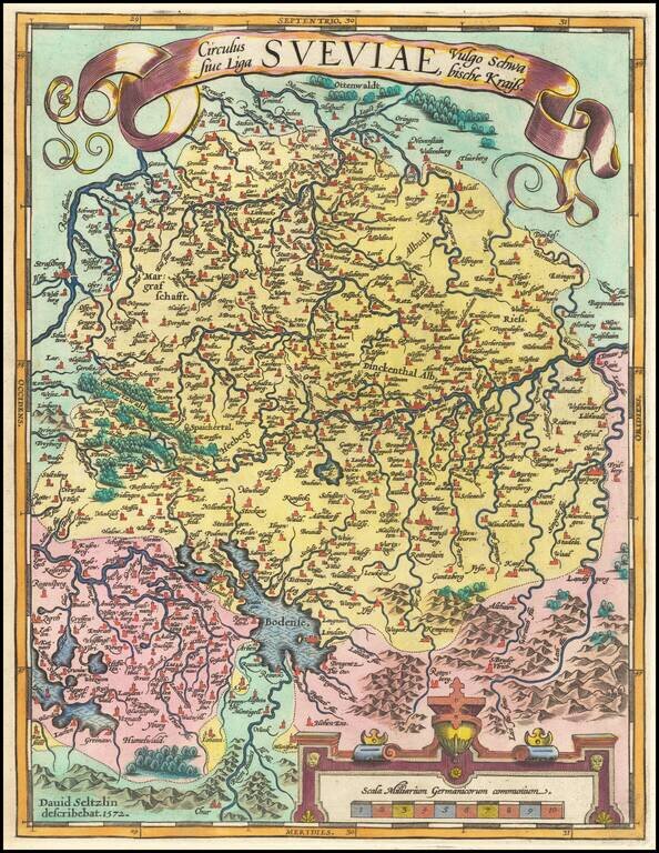
Fine old color example of Ortelius' regional map of Swabia, bounded by the Bodensee, Rhein and Augsburg, centered on the Donau (Danube) River. From Ortelius' Theatrum Orbis Terrarum, the first modern atlas of the World.
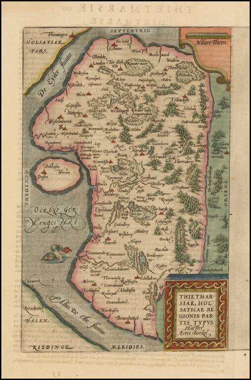
A nice full color example of Ortelius's regional map of the region known as Dietmarschen in Schleswig Holstein, at the mouths of the Elbe and Eider rivers, including Brunsbuttel and Meldorf. This map appeared in Abraham Ortelius's Theatrum Orbis...
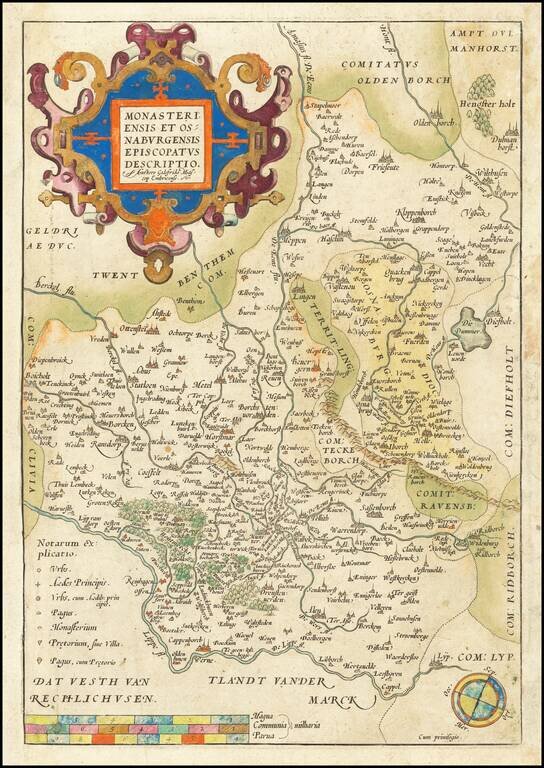
Decorative example of Ortelius' map showing the region north of the Lippe River, centered on Munster. A nice old color example.
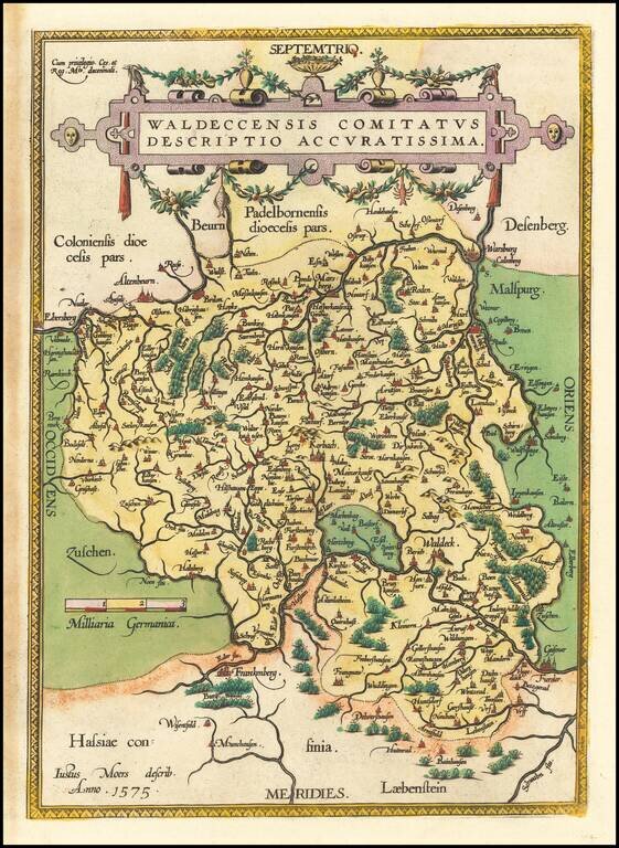
Nice example of Ortelius' regional map of the Waldeck region, with decorative cartouche, compass rose, etc. From Ortelius' Theatrum Orbis Terrarum, the first modern atlas of the World.
![Turingiae Noviss Descript. Per Iohannem Mellinger Halens [with] Misniae et Lustaiae Tabula Descripta a. M Bartholomeao Sculteto Gorlit.](/map/small/61448.jpg)
Nice old color example of Ortelius' regional maps of Germany. The first map shows the regions of the Sala, Hel and Werra Rivers, from Hall, Merburg and Naumburg to Cruetzberg and Saltzungen, centered on Erfundt. The second shows the region centered...
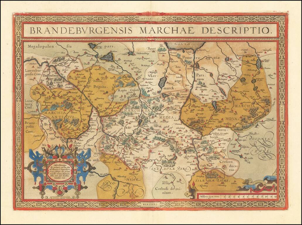
Fine old color example of Abraham Ortelius' map of the Brandenburg and Berlin regions. The map focuses on the Albis River and Oder River regions in Germany and extending to Silesia.
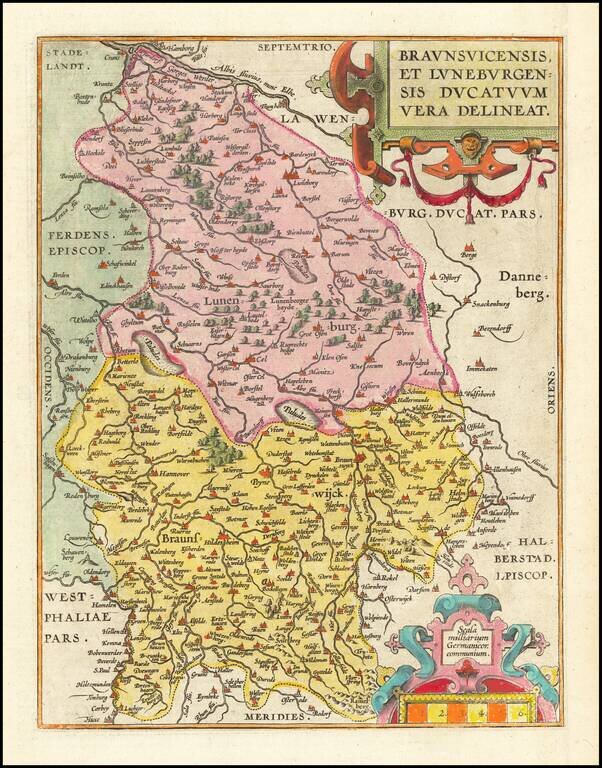
Fine old color example of Abraham Ortelius's map of the Duchies of Braunswick and Lunenburg. Large cities appearing on the map include Hanover, Luneburg, Wolfsburg, Brunswick, Peine, Wolfenbuttel and Hamburg. The map appeared in Ortelius's Theatrum...
![Thietmarsiae, Holsaticae Regionis Partis Typus [with] Oldenburg Comit.](/map/small/61510.jpg)
A nice full-color example of Ortelius' maps of a part of Schleswig-Holstein and Oldenburg, from his Theatrum Orbis Terrarum. Major towns shown include Oldenburg and Bremen. Abraham Ortelius Abraham Ortelius (1527-1598) was, along with Gerard...