Abraham Ortelius is perhaps the best known and most frequently collected of all sixteenth-century mapmakers. Ortelius started his career as a map engraver. In 1547 he entered the Antwerp guild of St Luke as afsetter van Karten. His early career was as a business man, and most of his journeys before 1560 were for commercial purposes. In 1560, while traveling with Gerard Mercator to Trier, Lorraine, and Poitiers, he seems to have been attracted, largely by Mercator’s influence, towards a career as a scientific geographer. From that point forward, he devoted himself to the compilation his Theatrum Orbis Terrarum (Theatre of the World), which would become the first modern atlas.
In 1564 he completed his “mappemonde", an eight-sheet map of the world. The only extant copy of this great map is in the library of the University of Basle. Ortelius also published a map of Egypt in 1565, a plan of Brittenburg Castle on the coast of the Netherlands, and a map of Asia, prior to 1570.
On May 20, 1570, Ortelius’ Theatrum Orbis Terrarum first appeared in an edition of 53 maps. By the time of his death in 1598, a total of 25 editions were published including editions in Latin, Italian, German, French, and Dutch. Later editions would also be issued in Spanish and English by Ortelius’ successors, Vrients and Plantin, the former adding a number of maps to the atlas, the final edition of which was issued in 1612. Most of the maps in Ortelius Theatrum were drawn from the works of a number of other mapmakers from around the world; a list of 87 authors is given by Ortelius himself
In 1573, Ortelius published seventeen supplementary maps under the title of Additamentum Theatri Orbis Terrarum. In 1575 he was appointed geographer to the king of Spain, Philip II, on the recommendation of Arias Montanus, who vouched for his orthodoxy (his family, as early as 1535, had fallen under suspicion of Protestantism). In 1578 he laid the basis of a critical treatment of ancient geography with his Synonymia geographica (issued by the Plantin press at Antwerp and republished as Thesaurus geographicus in 1596). In 1584 he issued his Nomenclator Ptolemaicus, a Parergon (a series of maps illustrating ancient history, sacred and secular.) Late in life, he also aided Welser in his edition of the Peutinger Table in 1598.
![Gallia Narbonens [on sheet with] Savaudiae Ducat. [on sheet with] Venuxini Comitatus Descr.](/map/small/61542.jpg)
Fine old color example. The regions include a detailed area map of the Avignon region on the upper Rhodanus River (and coastline from Narbone to Marseille) and the area around Lake Geneva, extending west to Lyon, and showing Grenoble, Geneva, San...
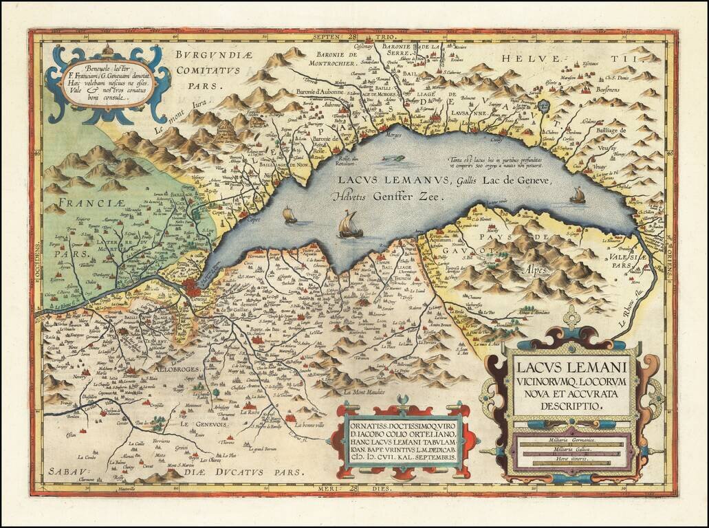
Fine example of Jan Baptiste Vrients' map of the Lake Geneva region, which first appeared in the 1608 edition of Ortelius' Theatrum Orbis Terrarum. A number of islands shown off the coast. Includes 3 sailing ships, a sea monster and 3 large...

Decorative example of this fine map of Northern Italy and contiguous regions, extending from Venice on the Adriatic, to Pisa and Nice on the Mediterranean, to Lake Geneva in the west, and the Alps in the North, from Ortelius' Theatrum Orbis Terrarum,...

Striking regional map, centered on Lake Geneva, based upon a map from Abraham Ortelius's Epitome. The map is oriented with East at the top and extends to Basel and Strasbourg in the North, Turin and Grenoble in the south, and Dijon and Lyon in the...
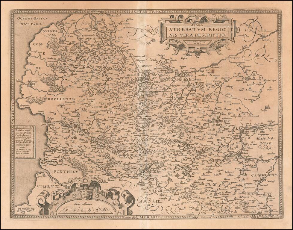
Detailed regional French map, extending from Abbeville Auxy and Cambray to Lille and Cales. Detail and cartouches consistent with Ortelius's usual cartographic skills.
![Regionis Biturigum Exactiss: Descriptio Per D. Ioannem Calamaeum [with] Limaniae Topographia Gabriele Symeoneo Auct.](/map/small/61579.jpg)
Nice old color pair of regional maps of France. The larger map covers the Loire region from Gian to Le Blang and Argenton, centered on Chateau Neuf and Bourges. The smaller map shows the area around Beauregard and Cleremont.
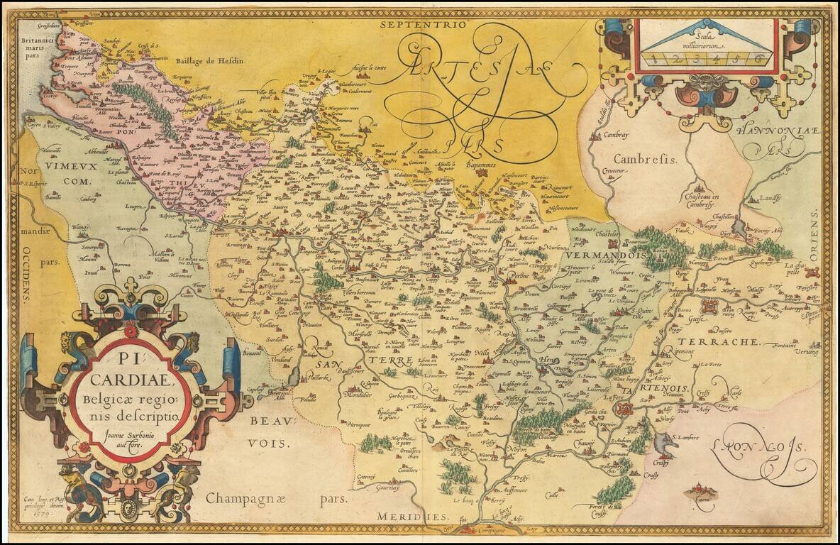
Fine old color example of this regional map of Picardie, from Ortelius' Theatrum Orbis Terrarum, the first modern atlas of the world, first published in 1570. Ornate cartouche and scale of miles.
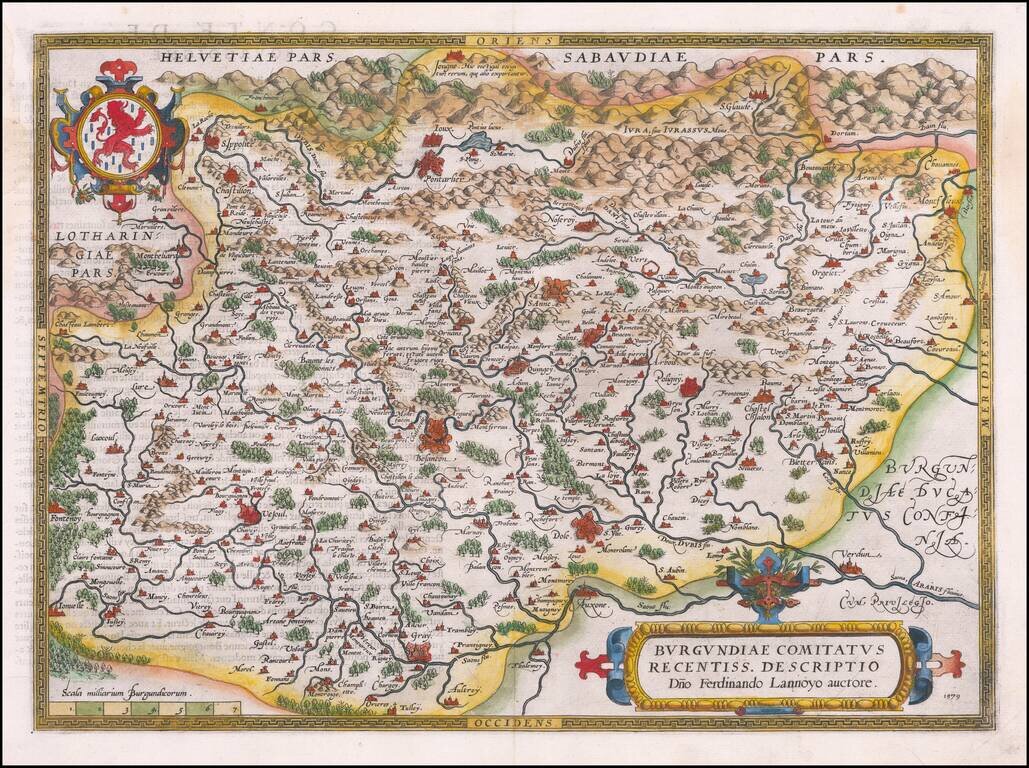
Beautifully hand-colored, decorative regional map of Burgundy in France, centered on Besancon, Poligny, Quingey and St Anne. Includes a number of famous wine regions, from Ortelius's Theatrum Orbis Terrarum, the first modern atlas of the world. The...
![Palatinatus Bavariae Descriptio . . . [with] Wirtenbergensis Ducatus...](/map/small/65838.jpg)
Fine pair of maps, published by Abraham Ortelius. Ortelius' map of Bayern is based on the map by Erhart Reich. The map includes Regensberg, Nuremberg and Bamberg. The map of the Rhine, both south and north of Strassbourg is based on Daniel Specklin's...
![[Anjou] Andegavensium Ditionis Vera Et Integra Descriptio](/map/small/50232.jpg)
Attractively hand-colored regional map of France, centered on the Loire River and Angiers. Includes several bridges across the Loire and its tributaries. Abraham Ortelius Abraham Ortelius (1527-1598) was, along with Gerard Mercator, the most...
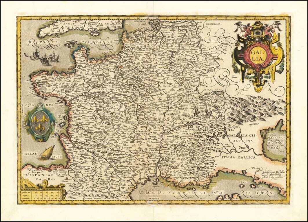
An Exceptional Ortelius Rarity in Wonderful Condition. Van Den Broecke Estimates "Five or six copies have survived." Proof state of this separately-issued map of France, published by Abraham Ortelius and drawn by Guillaume Postel. Van Den Broecke...
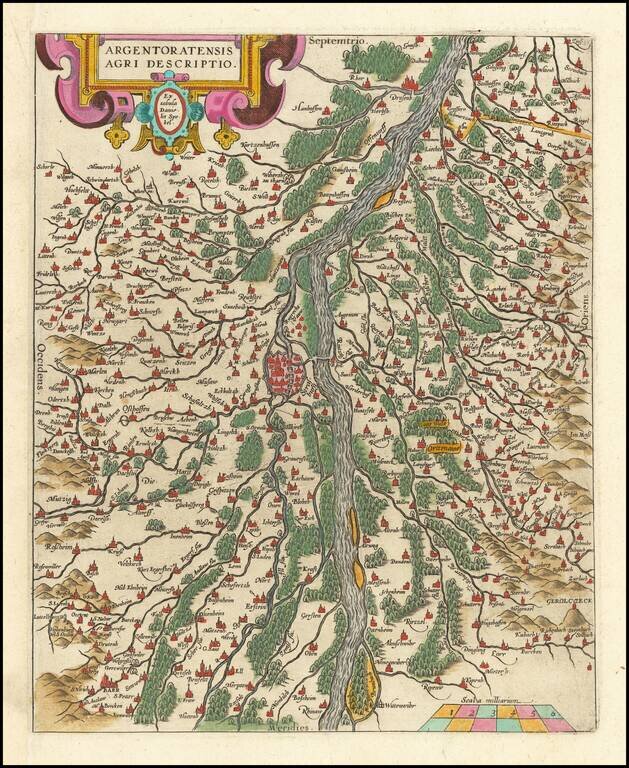
Fine old color example of this map of the Rhine, both south and north of Strasbourg, based on Daniel Specklin's three-sheet map of the Elzas of 1576. From edition of Ortelius' Theatrum Orbis Terrarum, the first modern atlas of the World.
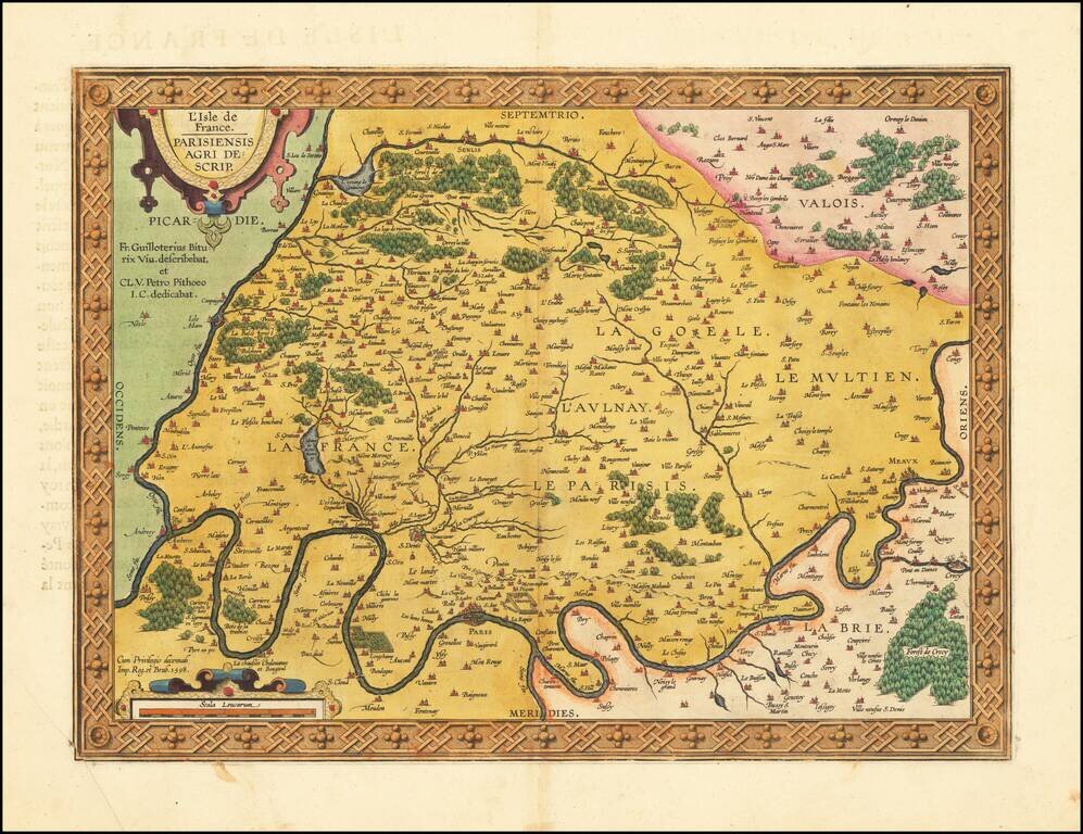
Fine old color example of this important early map of the region around Paris and the Isle de France, published by Abraham Ortelius in Antwerp. The map appeared in Ortelius' Theatrum Orbis Terrarum, the first modern atlas of the world. The map is...
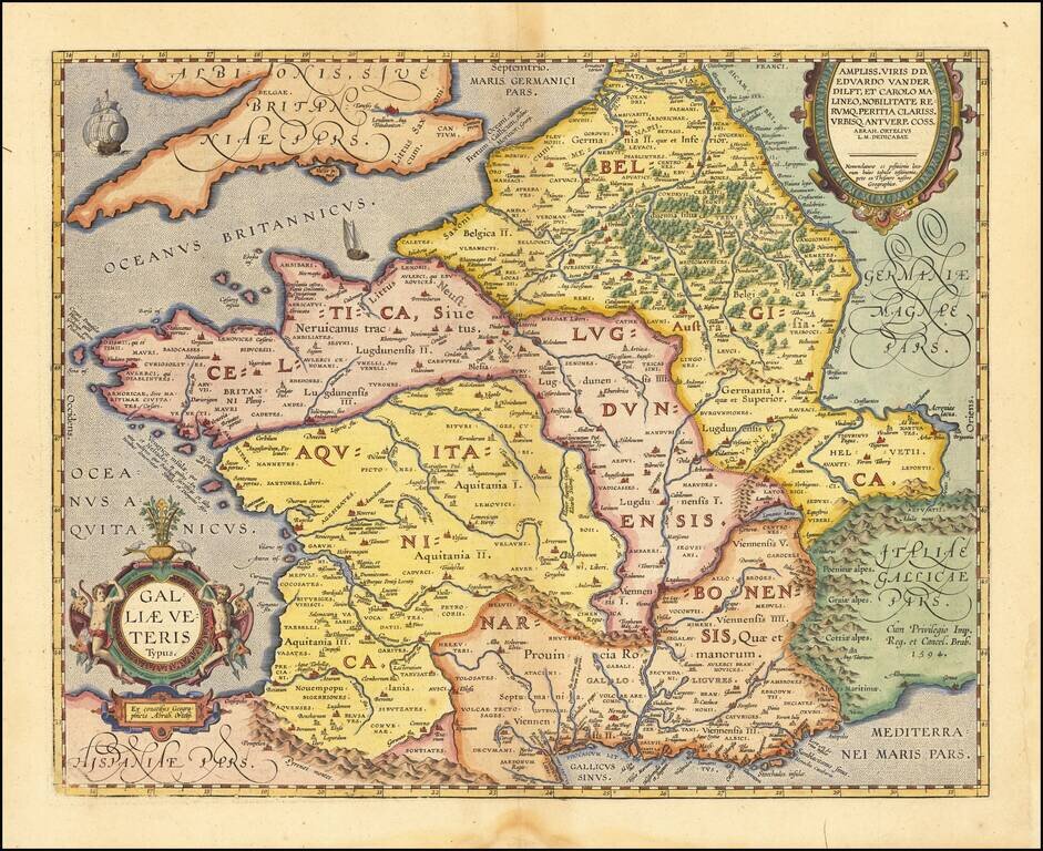
Detailed Ortelius Map of France in Roman Times, Based on Classical Sources Vivid map of Ancient France from Ortelius' Parergon, the first historical atlas. The map is based upon information from classical sources such as Strabo, Virgil, Ovid and...
![[Bavaria] Vindeliciae Sive Utriusque Bavariae Secundum antiquum & recentiorem situm, ab Joanne Auetino olim descriptus, Principibusque eiusdem regionis dedicatus, atque Landshuti editus Anno à Christo nato. 1533](/map/small/61449.jpg)
Scarce example of Ortelius' first map of Bavaria. This first state was issued from 1570 to 1572, with an additional 25 copies printed in 1573, before the second map of Bavaria was issued (Van Den Broecke 110). As noted in the title, the map is drawn...
![[Unrecorded Variant] Franciae Orientalis (Vulgo Frankenlant) Descriptio](/map/small/61676.jpg)
Detailed regional map showing the Main River from its sources to Frankfurt, published by Abraham Ortelius. This is an unrecorded variant, not in Van Den Broecke. Text on verso is similar to the 1570A in Van Den Broecke, but Vulgo is the first word,...