Map size in jpg-format: 26.0925MiB
Click to open in high resolution (open in new tab).
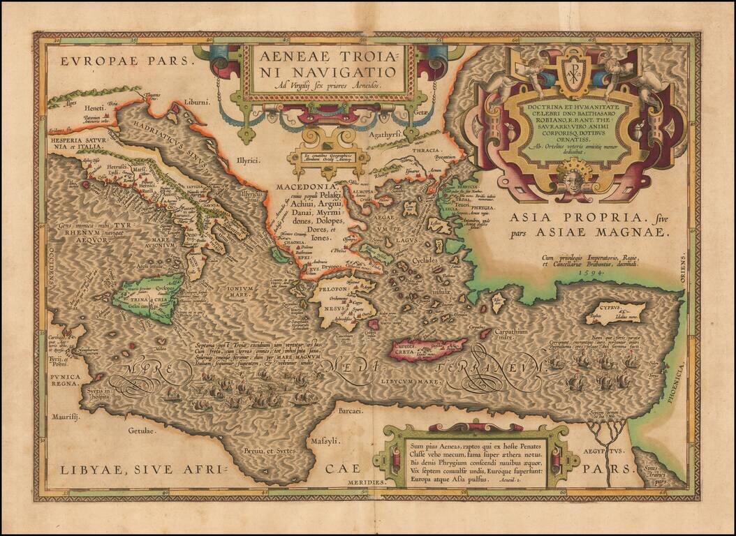
On the Trail of Aeneas, the Trojan—Historical Map of the Mediterranean Sea Chronicling the Story of the Aeneid
A finely-detailed map of the eastern Mediterranean Sea, published in Ortelius’ Parergon, his historical atlas of the ancient world. The map tells the story of the thrilling story of Aeneas, as told in the epic poem the Aeneid.
The map is oriented northward and depicts the Mediterranean region from Italy to Phoenicia on the eastern coast, which covers modern-day Syria, Lebanon, and Israel. The African continent is depicted with Tunisia (Punica Regna) and Libya (Libyae) in the southwest corner and Egypt (Aegyptus) in the southeast. The Nile River Delta is clearly drawn, as is the Suez Gulf (Sinus Arabici pars), which helped to separate Egypt and Phoenicia. Phoenicia and modern-day Turkey (Asia Propria) are to the east, while Italy (Italia) and Sicily (Trinacria) are to the west. Greece (Macedonia) and the island of Crete (Creta) take up the top-center of this map. The Mediterranean Sea fills the middle of the map and has beautifully-engraved wave patterns throughout.
Three intricate strapwork cartouches take up space on the landforms, particularly on the northern edge of the map. The central cartouche reads Aeneae Troiani Navigatio Ad Virgilij sex priores Aeneidos, the title of the map, which translates to “The sea journey of the Trojan Aeneas, after the first six books of the Aeneid by Virgil.” Smaller text underneath indicates the cartographer, Abraham Ortelius.
In the northeast corner of the map, the largest cartouche includes two cherubic figures in addition to the strapwork. There is also a seal with the chi-rho and alpha-omega symbols, which are used together as a symbol of Jesus’ divinity. The text in this cartouche dedicates the map to Balthasar Robiano, a close friend of Ortelius.
The third cartouche is on the southern edge of the map and contains a verse from the first book of the Aeneid, which introduces Aeneas on his journey as he sails the Phrygian Sea after being driven from Troy. All of the cartouches make use of texture and shading which give them a three-dimensional appearance.
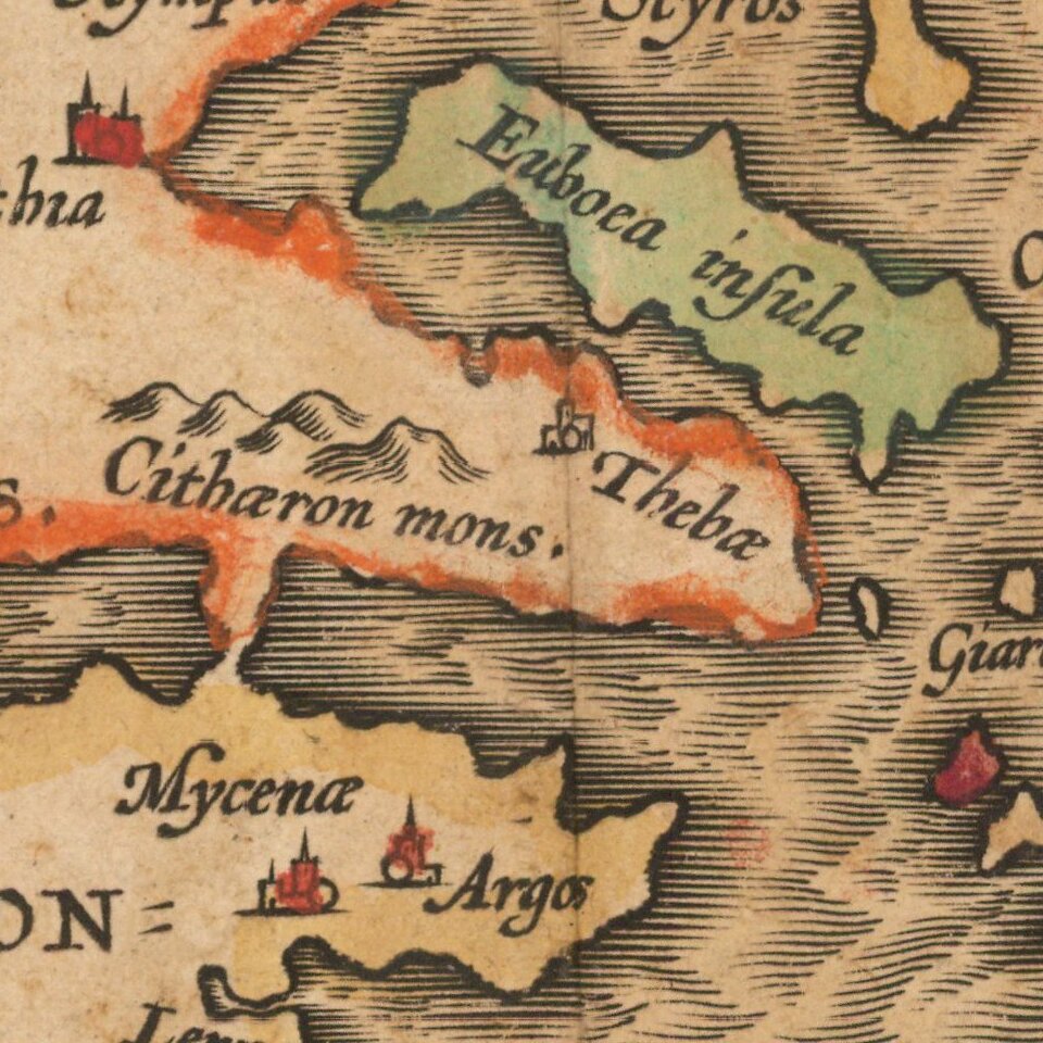
In the landforms, certain details standout such as the mountain ranges (for example, the Alps and the Apenninus in Italy), some small forests on Crete, and the cities, which are all individually drawn. The coastlines of Italy and Greece are particularly detailed, and these countries are by far the most labeled, indicating their importance in the mythology.
However, it is clear that in this map the Mediterranean Sea is as important as the land. The sea is carefully filled in to give it the appearance of choppy waves, and the ships drawn sailing it are rendered in such detail that the oarsmen can be seen on some near the coast of Libya.
Numerous mythological places can be found on the map. Mount Olympus is located on the eastern coast of Greece (Macedonia), as are the cities of Thebes (Thebae) and Phythia, home of the hero Achilles. The home of the Cyclopes as well as Scylla and Charybdis (Charydis), all monsters that Odysseus faced in the Odyssey, are located on Sicily and southern Italy, while the island of Ithaca, Odysseus’s home, is on the west coast of Greece.
Aeneid
The Aeneid was written by the Roman poet Virgil, and it tells the story of Aeneas as he wandered the Mediterranean Sea in search of a new home after escaping the destruction of Troy. The poem, written many years after Homer’s epics the Iliad and the Odyssey, took inspiration from these older tales while also setting up Aeneas as a key figure in the founding of Rome. He was an important hero, yet as a Trojan, he was also an enemy of the Greeks. This made him a good figure to legitimize the creation and power of Rome through the creation of a mythical history surrounding him.
Aeneas was a great warrior and a hero of Troy but, following the destruction of Troy as told in Homer’s Iliad, the hero Hector came to Aeneas in a vision and told him to flee the city. Aeneas roamed the seas for seven years with a band of surviving Trojans, beginning with a fleet of twenty ships, of which only seven survived the seven-year ordeal. On this map, the twenty original ships are depicted off the coast of Libya, some clearly sinking or in peril. The seven remaining ships can be seen near the Nile River Delta.
On his journey, Aeneas has several adventures and encounters similar to Odysseus’ in the Odyssey, and many of the places he goes can be found on the map. He sails west from Troy (Troia) in Phrygia toward Italy, where he is beset by a storm that destroys some of his fleet. He lands instead at the city of Carthage on the coast of Tunisia (Punica Regna), where he falls in love with the widowed queen Dido. However, he is prompted by the gods to leave Carthage. Later, the Trojans head to Cumae on the western coast of Italy, where Aeneas ventures into the Underworld. Finally, Aeneas and the remaining Trojans settle at the mouth of the Tiber River (Tibris flu.), near the future site of Rome.
Parergon
Although best known for his world atlas, the Theatrum Orbis Terrarum, the Parergon was a project of personal interest and the work that Ortelius himself considered his greatest achievement. He had a deep interest in classical antiquity which spurred him to create the Parergon maps, and the amount of time and detail he put into each map is clearly evident. Rather than copying from existing maps, as he had done for the Theatrum, Ortelius hand drew each map of the Parergon, which required considerable skill and knowledge of the area’s history and geography. It is considered the first historical atlas.
Parergon means supplementary, and accordingly, the first three Parergon maps were published as supplements to the 1579 edition of the Theatrum, which had already been in print for nine years. Over time, successive editions of the Theatrum were supplemented with more Parergon maps, and there are 55 known plates overall. The Parergon was also published as its own atlas separate from the Theatrum on two occasions, once in 1595 and again in 1624.
The Parergon was highly successful both as a supplement to the Theatrum and on its own. It was variously translated into French, German, Italian, and English and regularly printed until 1612. Further editions were more sporadic but still popular, such as the 1624 edition which was published twenty-six years after Ortelius’ death in 1598.
This exciting map and indeed the entire Parergon blends geography, history, and myth, and the level of detail present speaks to Ortelius’ skill as a mapmaker and his dedication to his craft. This would be a valuable addition to a collection of Mediterranean maps, Ortelius maps, or maps of classical antiquity.
If you are a student, write to us in telegram: @antiquemaps and indicate what material you need and for what work you need a map in high detail. We are ready to provide material on special terms. For students only!


