Abraham Ortelius is perhaps the best known and most frequently collected of all sixteenth-century mapmakers. Ortelius started his career as a map engraver. In 1547 he entered the Antwerp guild of St Luke as afsetter van Karten. His early career was as a business man, and most of his journeys before 1560 were for commercial purposes. In 1560, while traveling with Gerard Mercator to Trier, Lorraine, and Poitiers, he seems to have been attracted, largely by Mercator’s influence, towards a career as a scientific geographer. From that point forward, he devoted himself to the compilation his Theatrum Orbis Terrarum (Theatre of the World), which would become the first modern atlas.
In 1564 he completed his “mappemonde", an eight-sheet map of the world. The only extant copy of this great map is in the library of the University of Basle. Ortelius also published a map of Egypt in 1565, a plan of Brittenburg Castle on the coast of the Netherlands, and a map of Asia, prior to 1570.
On May 20, 1570, Ortelius’ Theatrum Orbis Terrarum first appeared in an edition of 53 maps. By the time of his death in 1598, a total of 25 editions were published including editions in Latin, Italian, German, French, and Dutch. Later editions would also be issued in Spanish and English by Ortelius’ successors, Vrients and Plantin, the former adding a number of maps to the atlas, the final edition of which was issued in 1612. Most of the maps in Ortelius Theatrum were drawn from the works of a number of other mapmakers from around the world; a list of 87 authors is given by Ortelius himself
In 1573, Ortelius published seventeen supplementary maps under the title of Additamentum Theatri Orbis Terrarum. In 1575 he was appointed geographer to the king of Spain, Philip II, on the recommendation of Arias Montanus, who vouched for his orthodoxy (his family, as early as 1535, had fallen under suspicion of Protestantism). In 1578 he laid the basis of a critical treatment of ancient geography with his Synonymia geographica (issued by the Plantin press at Antwerp and republished as Thesaurus geographicus in 1596). In 1584 he issued his Nomenclator Ptolemaicus, a Parergon (a series of maps illustrating ancient history, sacred and secular.) Late in life, he also aided Welser in his edition of the Peutinger Table in 1598.
![[Ortelius Portrait] Spectandum dedit Ortelius mortalib. orben, Orbi spectandum Galleus Ortelium](/map/small/68810.jpg)
Finely colored example of the portrait of Abraham Ortelius, which was engraved by Philip Galle and first appeared in the 1579 edition of his Theatrum Orbis Terrarum, the first modern Atlas. The text translates as follows: "By looking, Ortelius gave to...
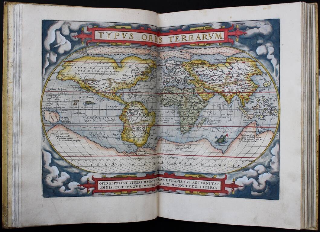
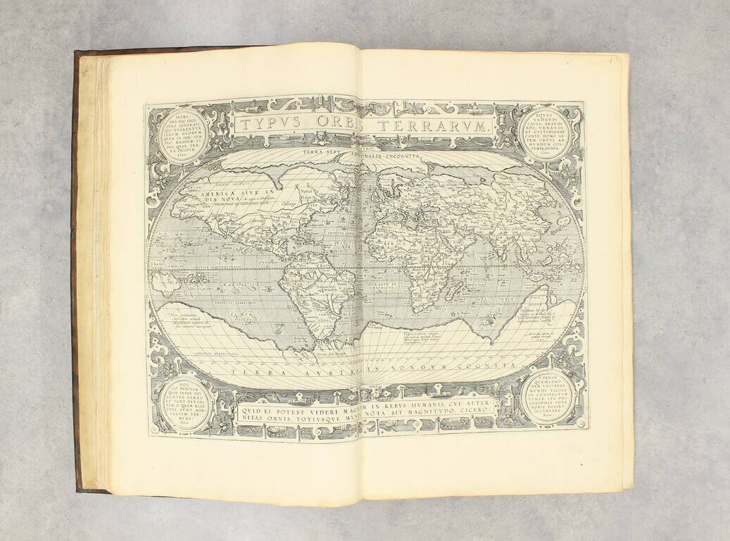
The First Modern Atlas of the World [39] preliminary text leaves (including engraved title), 53 hand-colored double-page engraved maps, all mounted on original guards. Antwerp: Gielis Coppens van Diest, 1571. Folio (16.25 x 11.5 inches),...
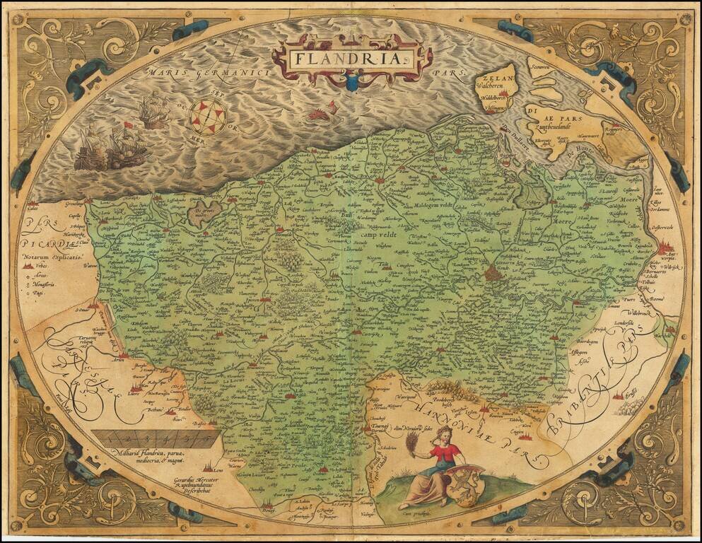
A nice example of Ortelius's second map of Flanders, from the 1584 Latin edition of his Theatrum Orbis Terrarum, the first modern atlas of the world. The map is executed inside of a decorative strapwork egg-shaped border and is one of the most...
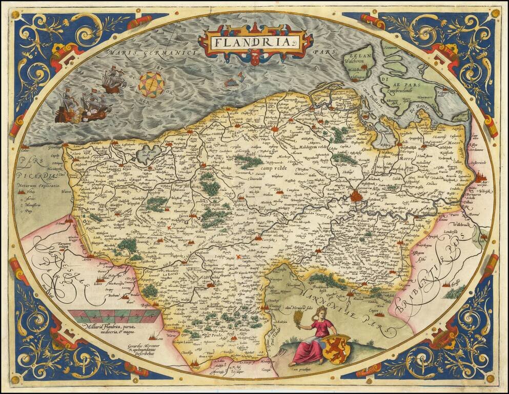
A nice example of Ortelius's second map of Flanders, from the 1584 Latin edition of his Theatrum Orbis Terrarum, the first modern atlas of the world. The map is executed inside of a decorative strapwork egg-shaped border and is one of the most...
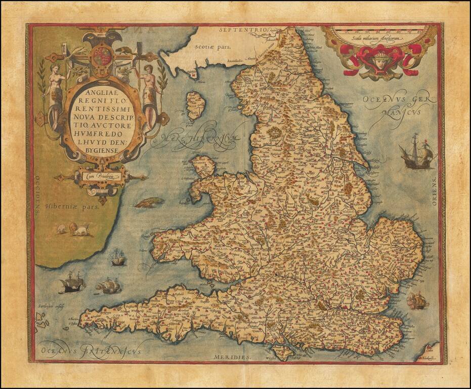
A gorgeous old color map of England and Wales, from the 1574 Latin edition of Ortelius' Theatrum Orbis Terrarum, the first modern atlas of the world. Included are an ornate cartouche and many sailing ships and sea monsters, as well as some sheep...
![(Atlas) Theatrum orbis terrarum [with] Parergon [and] Nomenclator Ptolemaicus](/map/small/49333.jpg)
First Printing of the First Plantin Edition of the "First Modern Atlas", and the First Edition with the Parergon. Folio, handsome contemporary full calf tooled in blind (almost entirely unsophisticated but for artful reinforcement of the head and foot...
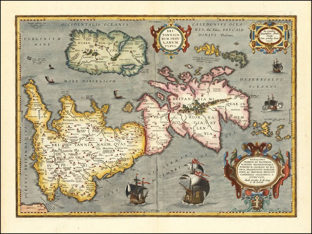
Notable Atlas Map of the British Isles, From the First Modern Atlas Scarce, fine map of the British Isles, from Ortelius' ground-breaking atlas, Theatrum Orbis Terrarum. Oriented to the west, the British Isles are shown as if on their side. The...
"This is the most advanced Latin edition of the Theatrum published by Vrients." - Koeman (Ort 36) [A6, including engraved title page], [B6], [C6], [D4], and 118 double-page engraved maps all of which with Latin text on verso. This copy is complete...

The First Modern Atlas of the World [39] preliminary text leaves (including engraved title), 166 hand-colored double-page engraved maps (lacking 10 preliminary sheets of text (A6, B1-6, D3-5), 3 maps and 2 plates (Piedmont, Parma and Plaisance,...
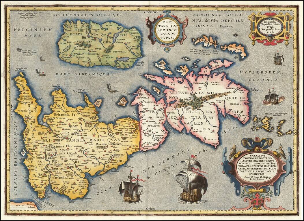
Notable Atlas Map of the British Isles, From the First Modern Atlas Scarce, fine map of the British Isles, from Ortelius' ground-breaking atlas, Theatrum Orbis Terrarum. Oriented to the west, the British Isles are shown as if on their side. The...
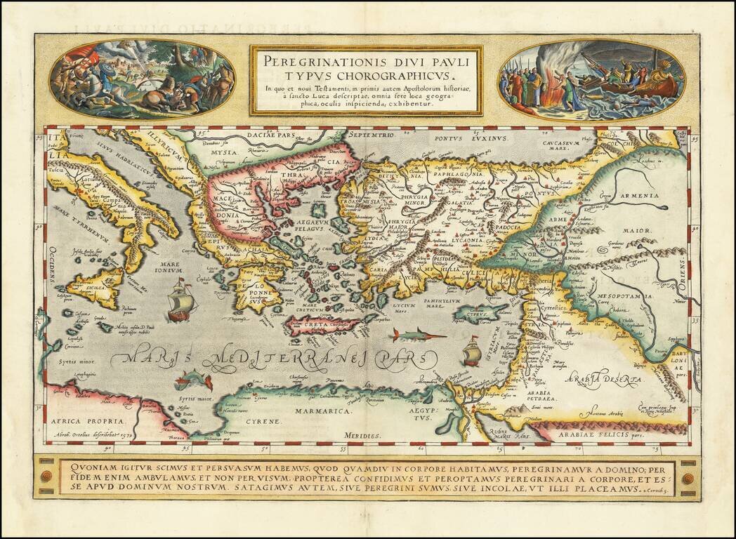
A gorgeous example of Ortelius' map of the travels of St. Paul the Apostle through the Mediterranean, extending west to Italy and east to the Euphrates, including parts of the Red Sea and the Black Sea. Several sailing ships and sea monsters in the...