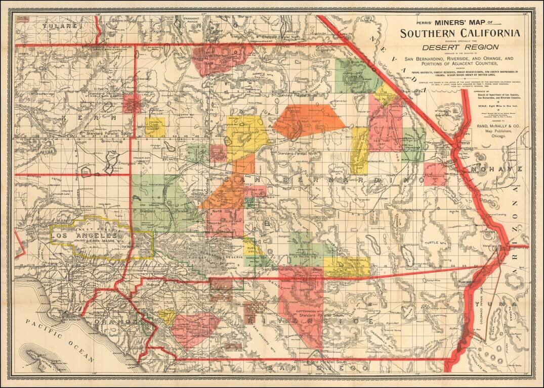
First State of Perris' Rare Mining Map of Southern California Rare map of the Desert Region of Southern California, focusing in on the regions Mining Districts, Forest Reserves and Indian Reservations. The map is criss-crossed with early Southern...
![[Site of A Presidential Assassination] Plan of the Pan American Exposition to be held at Buffalo, New York (May 1 - Nov. 1, 1901)](/map/small/69181.jpg)
The Site of William McKinley's Assassination in September 1901 Finely executed plan of the Pan American Exposition grounds, which were to be held in Buffalo in 1901. As noted, the map shows the revisions of the plan as of August 15, 1900. The map...
![[Joseph Fischer's Rediscovery of Waldseemüller's Universalis Cosmographia] Die atleste Landkarte mit dem Namen Amerika](/map/small/67232.jpg)
A fascinating ephemeral document from the history of the history of cartography; a contemporary German-language newspaper account of Professor Joseph Fischer's rediscovery of the famous Waldseemüller Universalis Cosmographia (and several other great...
![[San Francisco Fire Satirical Cartoon] Uncle Sam -- Smoke Up Frisco! You're Bound To Be Bigger and Better Than Ever Before!](/map/small/70102.jpg)
Uncle Sam Reflecting Upon Aid To San Francisco Following The 1906 Earthquake Provocative image of Uncle Sam smoking a cigar and reflecting upon the $20,000,000 in aid contributed to San Francisco, following the 1906 San Francisco Earthquake. The...
![[San Francisco Fire Satirical Cartoon] Judge -- Never Mind Sister; They're All Going To Help](/map/small/70101.jpg)
Financial Aid To San Francisco Following The 1906 Earthquake Fascinating Image Showing a Statue of Liberty-like image of San Francisco in the wake of the 1906 earthquake, with a caricature of a wave of financial aid coming to help the city, , drawn...
![[San Francisco View] Schmidt Lithograph Co. Second and Bryant Sts. San Francisco, California](/map/small/64719.jpg)
Birdseye View Calendar Showing the Schmidt Printing Works Against the San Francisco Sky Line Rare Calendar for 1908, published by the Schmidt Label & Litho. Co, and bearing the name of its sales agent in Portland, E. Shelley Morgan. In the late...
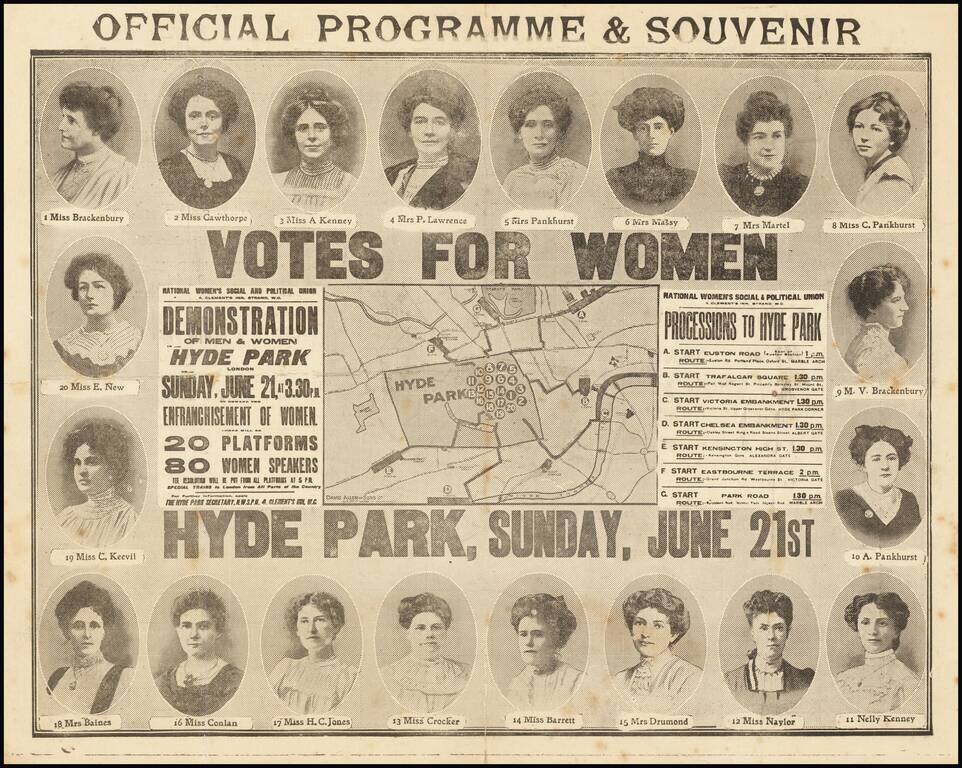
Separately Published Map of the Largest Suffragette March in the United Kingdom up to That Point. Rare separately-issued map of the Women's Sunday March of June 21, 1908, in Hyde Park, featuring the portraits of the 20 platform chairs. The map...
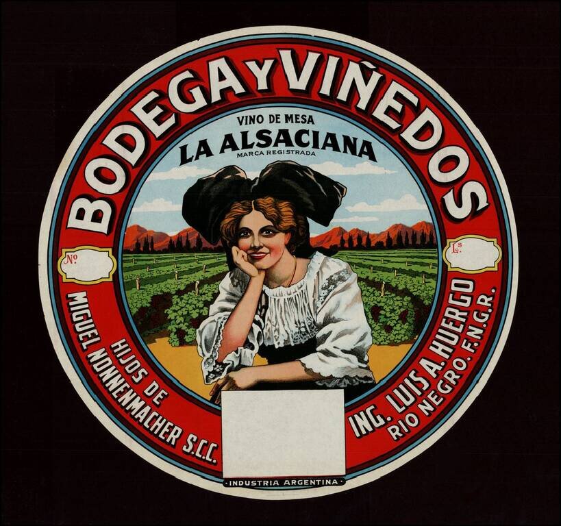
Decorative chromolithographic label for an Argentinian wine, intended to be placed on the wine barrel. The label is circular and has been laid on a black backround for imaging purposes only. The black background is not attached to the label.
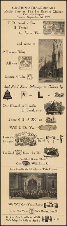
Interesting example of a Rebus -- a puzzle in which words are represented by combinations of pictures and individual letters. The present example was utilized by a church in Keene, New Hampshire, to attract attention to its call for members to attend...
![[Photo Album: Urban Military Academy -- Yosemite Summer Camp -- Hollywood Boys School -- Black Face Images]](/map/small/68607.jpg)
Summer Camp In Yosemite For Hollywood's Elite -- Includes Black Face Images and Indian Costume! Urban Military Academy Yosemite summer camp photo album, containing 11 black and white photographs of the summer excursion to Yosemite. Urban Military...
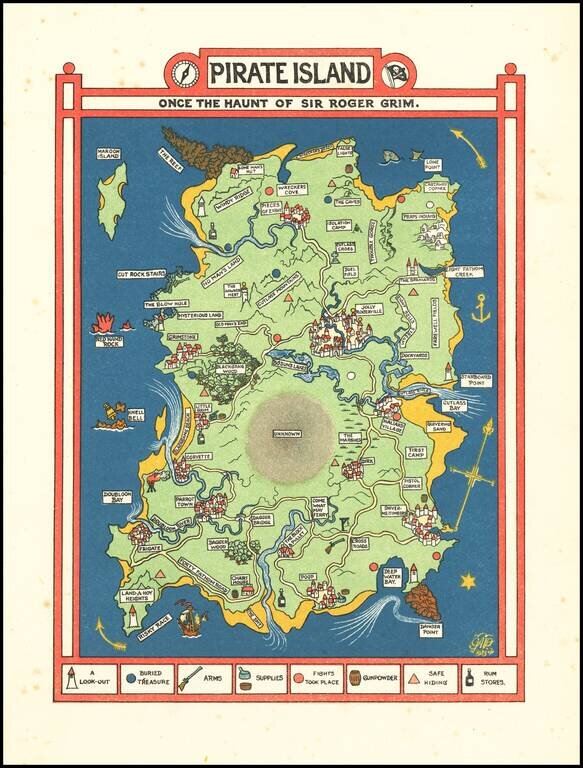
Excellent Golden-Age of Illustration Fantasy Map of a Pirate Island. Color-lithographed fantasy map of "Pirate Island" by Gilbert Anthony Pownall, published in London in 1924. The map includes a key showing: lookouts, buried treasure, arms, supplies,...
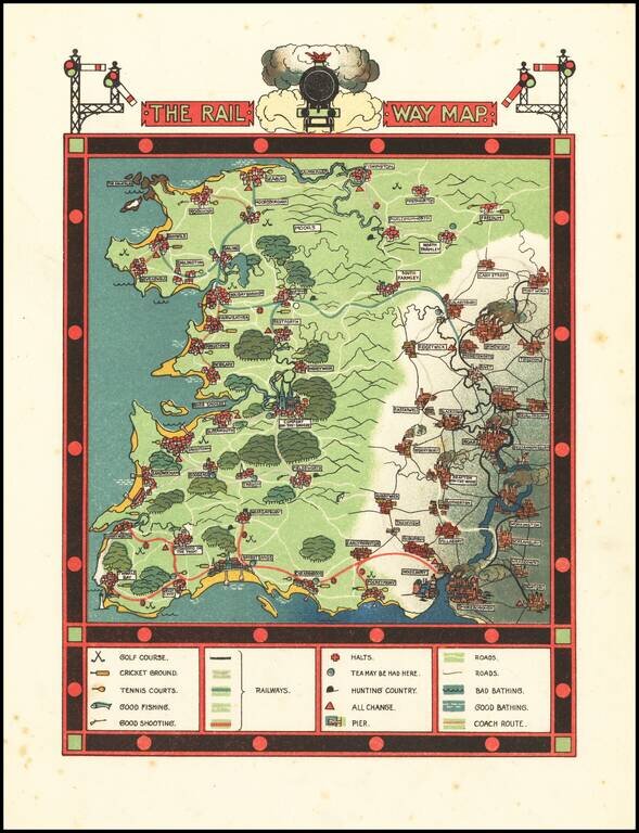
Excellent Golden-Age of Illustration Pictorial Map of the Go Where You Please Rail Way Scarce fantasy pictorial map, with accompanying text. The map was published in Traveller's Joy A Device, written by Dion Clayton Calthrop and illustrated by...
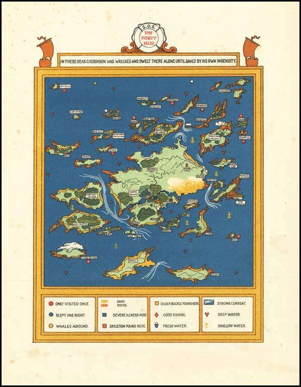
Excellent Golden-Age of Illustration Fantasy Map of the lands of Forty Isles of G. Robinson -- A Voyage of Self Discovery Scarce fantasy pictorial map -- very much of the period in terms of cultural and social values. "Fortunately for him, he found...
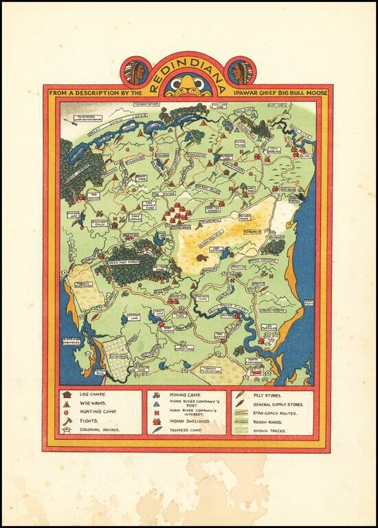
Golden-Age of Illustration Map of Redindiana (Fictious Land of American Indians] Color-lithographed fantasy map of "Redindiana" by Gilbert Anthony Pownall, published in London in 1924. The map and text tell the story of the taming and "westernizing"...
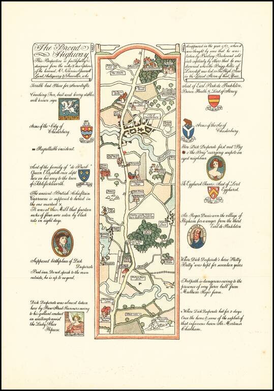
Golden-Age of Illustration Road Map of the Fictional Journey of Mr. Neronius Quarrell. Color-lithographed fantasy road map by Gilbert Anthony Pownall, published in London in 1924. The map was published in Traveller's Joy A Device, written by Dion...
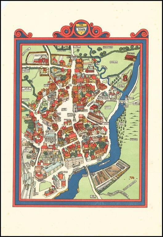
Golden-Age of Illustration of "The Market Town" Color-lithographed "market town, drawn by Gilbert Anthony Pownall, published in London in 1924. The map was published in Traveller's Joy A Device, written by Dion Clayton Calthrop and illustrated by...