logo

1924. The Rail Way Map

  • The Rail Way Map
  • The Rail Way Map

Map size in jpg-format: 9513040B

Download "The Rail Way Map", in high resolution.

The Rail Way Map information:

Year of creation: 
Resolution size (pixels): 
 5552x7243 px
Disk Size: 
 9513040B
Number of pages: 
 2
Place: 
 London

Print information. Print size (Width x height in inches):
Printing at 72 dpi 
  77.11 х 100.6
Printing at 150 dpi 
 37.01 х 48.29
Printing at 300 dpi 
 18.51 х 24.14

An example of detailing the file of this map of in a printable high-resolution:

Click to open in high resolution (open in new tab).
Attention! this is just the central piece (central area 960x960 px) of the map file!
This is an example, so that you can see and study the level of detail of a given map. The entire Map will be fully available after payment!

The Rail Way Map

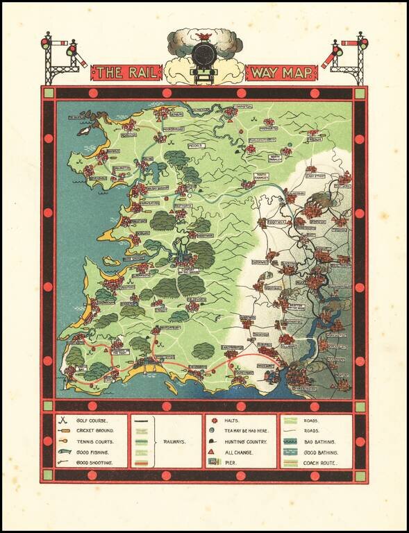
Excellent Golden-Age of Illustration Pictorial Map of the Go Where You Please Rail Way

Scarce fantasy pictorial map, with accompanying text.

The map was published in Traveller's Joy A Device, written by Dion Clayton Calthrop and illustrated by Gilbert Pownall.


Special conditions for students!

If you are a student, write to us in telegram: @antiquemaps and indicate what material you need and for what work you need a map in high detail. We are ready to provide material on special terms. For students only!

Item information:

Year of creation:
Size:
5552x7243 px
Disk:
9513040B
Number of pages:
2
Place:
London
Author:
Gilbert Anthony Pownall.
$14.99

Related item