Map size in jpg-format: 62.9503MiB
Click to open in high resolution (open in new tab).
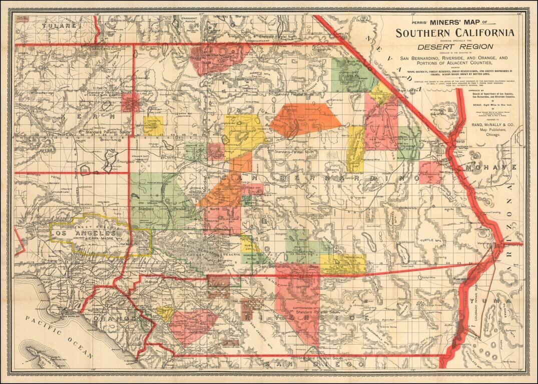
First State of Perris' Rare Mining Map of Southern California
Rare map of the Desert Region of Southern California, focusing in on the regions Mining Districts, Forest Reserves and Indian Reservations.
The map is criss-crossed with early Southern California Railroads, with wagon roads shown in dotted lines. This was a time period when Southern California Business and Government interests were attempting to irrigate much of the region with Colorado River and local mountain water supplies.
Compiled by Fred. T. Perris, one of the most influential mapmakers in this region at the end of the 19th Century, the map provides a rich tapestry of early details, coming shortly after the first Southern California real estate boom period.
The map indicates the major mining regions with swaths of color. Mining Districts showng include:
In addition, the lands reserved for hte Mission Indians and the Tule River Indians are shown in Brown.
Several major forestry reserves are located, including the Los Angeles / Sierra Madre Forest Reserve, San Bernardino Forest Reserve, Mount Trabuco Forest Reserve.
The first edition of the map was reviewed in the Book Review Section of Volume 15 of The Medical Age (1897) at page 535, which included the following entry:
Miners' Map Of Southern California. By Benjamin F. Levet and Fred T. Perris. Paper; 38x26 inches. Price, 50 cents. Rand, McNally & Co., Chicago. This is a very desirable map of Southern California, and it especially shows the desert region embraced in the counties of San Bernardino, Riverside, and Orange, as well as portions of adjacent counties; it also exhibits mining districts, forest reserves, Indian reservations, and county boundaries in colors; likewise wagon roads. Besides the above form it can also be had in cloth at seventy-five cents; as a wall map with paper back at same price; with cloth back for $1 50.Fred T. Perris
Fred Thomas Perris (1836 - 1916) was Chief Engineer of the Atchison, Topeka, and Santa Fe Railroad, who oversaw the construction of the last leg of the Second Transcontinental Railroad from Barstow, California through El Cajon Pass and down to San Bernardino and Los Angeles, a task that employed six thousand laborers, and is still in use by BNSF Railway and Union Pacific Railroad He also laid, track from Riverside, California to San Diego, California laying out a series to town sites along the track, one of which, Perris, California was named in his honor.
Perris was born in Gloucester, England, but moved to Australia when he was 12. In 1853, he moved again to San Bernardino, California, which was then an early Mormon settlement, where he was employed as a chain boy on an early surveying crew. In 1857, when the San Bernardino community failed, Perris moved to Salt Lake City. After briefly attempting a career as a photographer, Perris worked as a surveyor on the transcontinental railroad, then tried various buisnesses, including being one of the founders of the Salt Lake City Tribune.
In 1874, Perris moved back to San Bernardino, where he soon became the County Surveyor, where he was responsible for surveying and laying the foundations for the water system in America's largest county. When railroads came to the area he first went to work as Chief Engineer of the California Southern Railroad, a company chartered to build a rail line between San Diego on the coast and Barstow in the desert. When it was taken over in a merger, he advanced to Chief Engineer of the Atchison, Topeka and Santa Fe Railway, where he remained for the next 35 years. For a more complete life history of Fred Perris, click here: www.ci.san-bernardino.ca.us/about/history/fred_t_perris.asp
Rarity
The map is of the utmost rarity. We note two examples of the 1896 edition in OCLC (Library of Congress and UC Riverside) and only a single example of this 1902 edition (History Colorado).
We previously sold an example of the map in 2012 (1902 edition).
If you are a student, write to us in telegram: @antiquemaps and indicate what material you need and for what work you need a map in high detail. We are ready to provide material on special terms. For students only!


