
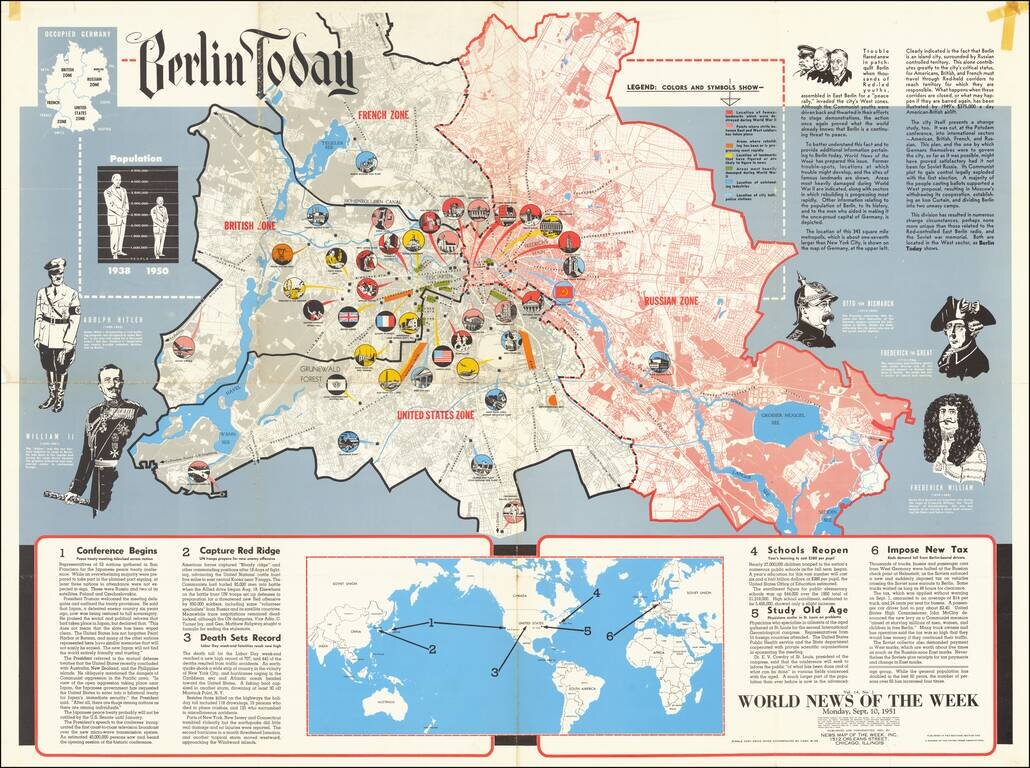
This is a detailed map of Greater Berlin, divided into its four occupied zones. Made at a time when the Cold War was at one of its many peaks, some recent conflicts had led to renewed public interest in the city, which had been the subject of its...
![[WWI Russian Propagandist Broadside: 'The Air War. - The Feats of Pegu']
Voina v vozdukhe. – Podvig Pegu.](/map/small/37962.jpg)
A Rare Russian World War I Propagandist 'Lubok' broadside, celebrating the feats of French fighter ace Adolphe Célestin Pégoud, printed in Moscow by Ivan Stylin. This amazing Russian WWI broadside shows the French fighter ace Adolphe Célestin...
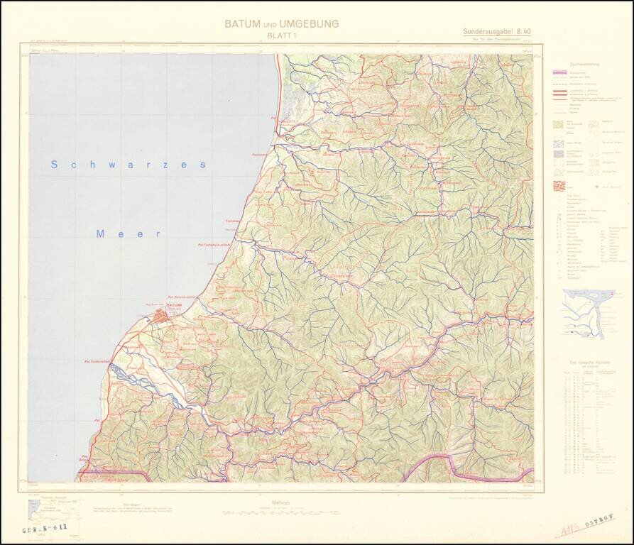
Four-sheet color-printed topographical map of the Adjarian Autonomous Soviet Socialist Republic and neighboring regions, prepared for strategic use by the General Staff of the German Army. The map is based on a 1917 German General Staff map. The area...
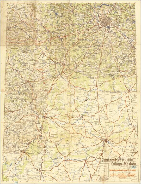
The Scene of the Wehrmacht Defeat Outside Moscow. Rare German plan of military positions and strategic landmarks between Kaluga and Moscow, published on the 8th of October, 1941, during the Battle of Moscow. The map shows the front as it existed in...
![Курская битва (Battle of Kursk) [Russian Educational Wall Map -- 1943]](/map/small/46011.jpg)
Fascinating Russian Educational Wall Map, illustrating and describing the Battle of Kursk in the Summer of 1943, with a vignette from the Battle. This map was likely used for teaching purposes, to Russian High School aged students, in the 1970s. The...

Czech-Published Map Celebrating the Victories of the 575th Motor Ambulance Company, Published in Pilsen in 1945. Fascinating separately issued map of Western Europe focusing on the movements and exploits of the American 575th Motor Ambulance Company,...
![[World War II -- The Italian Campaign] The Battle For Rome](/map/small/68200.jpg)
This Map Is Not For The Orderly Room. It Is To Be Displayed Where The Largest Number of People in the Unit Can Study it. This is a fine large map of the area around Rome, published in February 1944 by the British Army Bureau of Current Affairs...
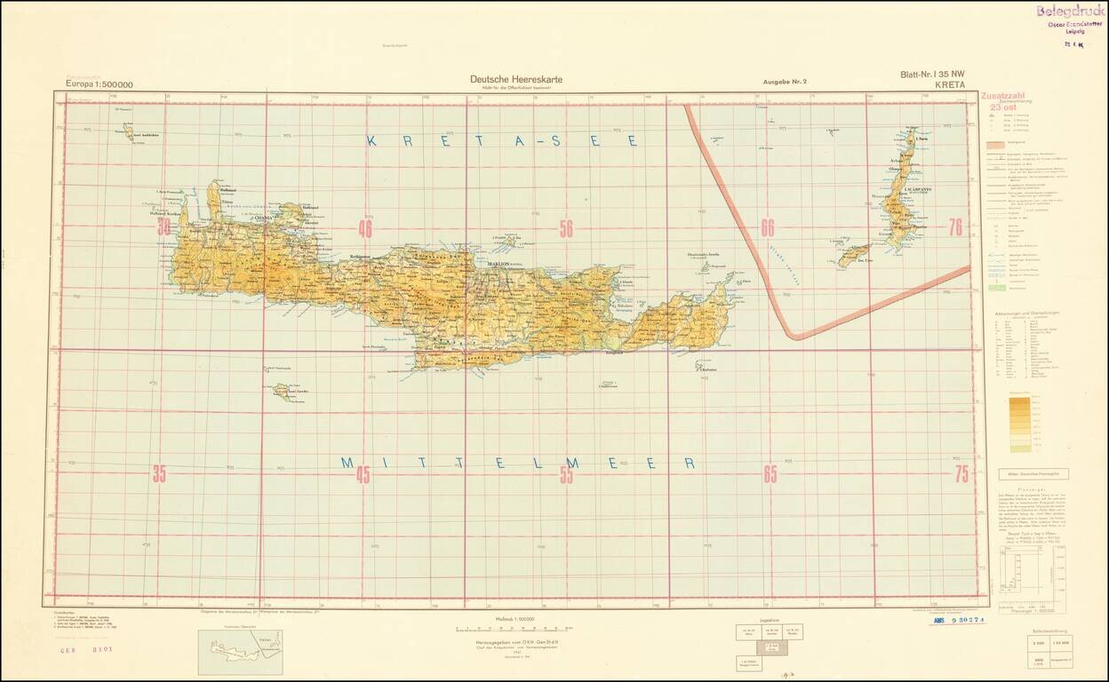
World War II-era German Army map of Crete, published shortly before the liberation of Crete from Germany occupation in October of 1944. The map is a sheet from the 1:500,000 Europa series and it is replete with topographical and political data. This...
![[China invasion detailed map]](/map/small/57053.jpg)
A detailed map of eastern China, showing parts of the densely populated Jiangsu, Zhejiang, and Anhui provinces. Includes an inset map of both Nanjing and Shanghai. The map shows topography, roads, major cities, and more around this area. Printed...
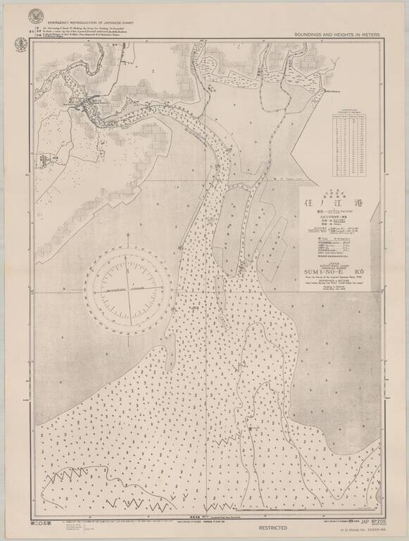
Scarce sea chart of part of the west coast of Kyushu, providing a fascinating insight into U.S. efforts to produce maps of Japan during World War II. The map, which was published by the Navy in September 1944, shows an area on the west coast of Kyushu,...
![(Second World War - Okinawa) [Large Battlefield Composite Map of Okinawa]](/map/small/63896.jpg)
6.5-Foot-Tall Battle-Used Map of Okinawa. Impressive battlefield composite map of Okinawa, composed of numerous sections of SECRET Army Map Service sheets cut and pasted together to form one large image. The map covers all of Okinawa, but for a small...
![(Second World War - Okinawa) [Battlefield Composite Map of Southern Okinawa]](/map/small/63897.jpg)
Battle-Used Map of Okinawa. Impressive battlefield composite map of Okinawa, composed of numerous sections of SECRET Army Map Service sheets cut and pasted together to form one large image. The map covers the southern most parts of Okinawa, including...
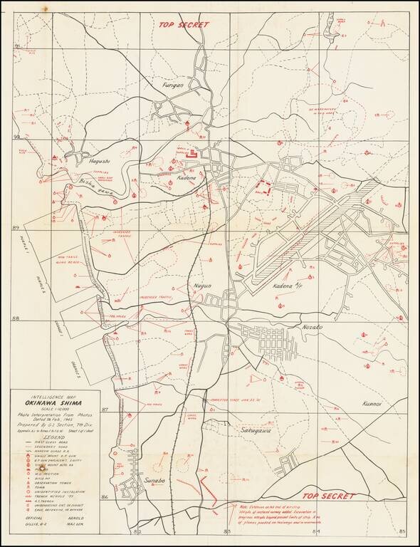
Top Secret American Map Used to Capture Kadena Airfield on Okinawa. Top Secret map of the Okinawa landing beaches Orange 1 & 2, and Purple 1 & 2, and the defenses between those beaches and Kadena airfield. The map was prepared based on...
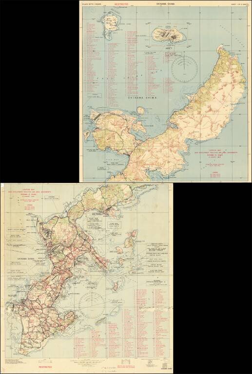
Restricted U.S. Military Map of Okinawa as it was Being Converted into a Major American Base. Color-printed map of Okinawa, produced by the 3020th Engr. Topo. Co. (Corps) on Okinawa, in September 1945, immediately after the end of World War II. The...
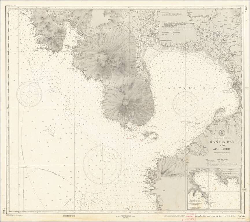
"RESTRICTED" World War II Map of Manila. Detailed chart U.S. Coast and Geodetic Survey (Philippine Divison) of Manila Bay, including Corregidor Island, originally published before the Japanese takeover during the early stages of the Second World War...
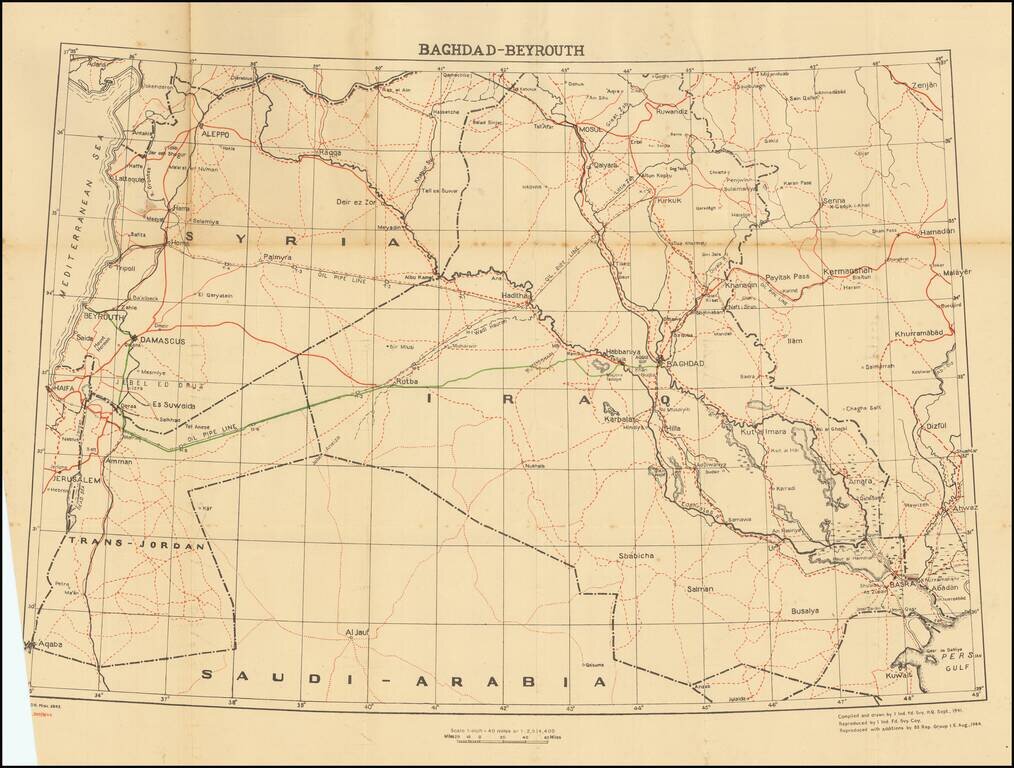
This is a fascinating map and pamphlet created for soldiers travelling in 1944 leave convoys. A major part of this journey included the road from Baghdad to Beirut, a 695-mile route through arid desert. Soldiers would head west from Baghdad until...