
![Bandar Abbas [U.A.E. and Strait of Hormuz]](/map/small/67305.jpg)
Detailed Second World War-era map of the Strait of Hormuz and what is now the United Arab Emirates. This is the third edition of the map, published in 1945. This is one of the most detailed maps available from this era. It includes oil wells and oil...
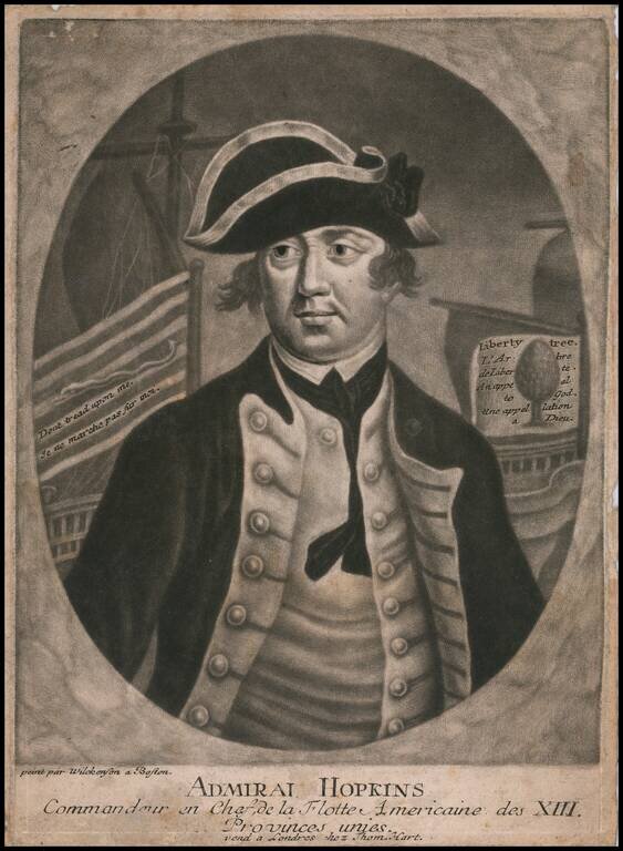
Finely executed mezzotint portrait of Esek Hopkins, the first person to serve as commander of the American Navy, during the American Revolution. The portrait was engraved and offered for sale in London. London publisher Thomas Hart, issued a series...
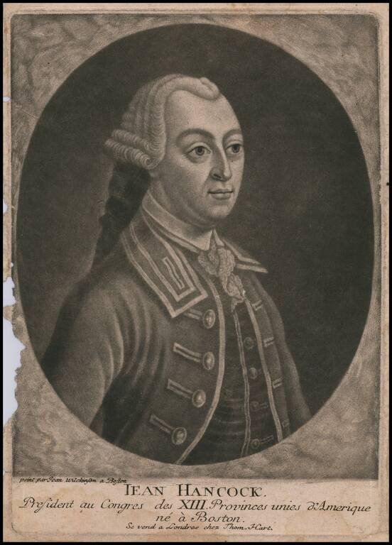
Finely executed mezzotint portrait of John Hancock, based upon a painting by John Wilkinson in Boston. The portrait was engraved and offered for sale in London. London publisher Thomas Hart, issued a series of mezzotints of 'revolutionary rebels',...
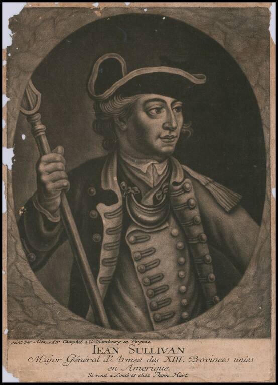
Finely executed mezzotint portrait of John Sullivan, which claims to be based upon a portrait by Alexander Campbell in Williamsburg, Virginia. Half length portrait in an oval within a rectangle, left arm extended, right hand holding pike, looking to...
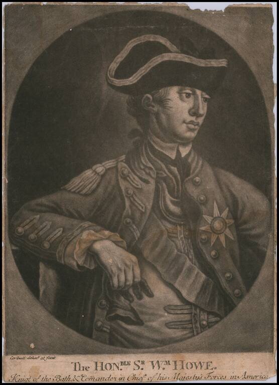
Finely executed mezzotint portrait of Sir William Howe, commanding officer of the British Forces during the American Revolution. An attractive mezzotint portrait of Howe, executed while he was serving as commander of the British forces in America from...
![[General George Washington]](/map/small/62386.jpg)
Striking full length portrait of a uniformed General George Washington, standing atop a hillside, with a battle scene from the American Revolutionary War raging on either side. Drawn from an unknown source. Handwriting on the verso suggests that it...
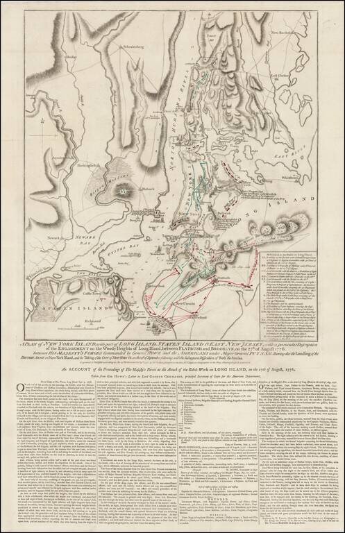
Rare Final State of Faden's Plan of the Battle of New York Fine example of Faden's separately issued broadside map showing the British Invasion of New York City in August and September of 1776. The present example is the final state of the map, with...
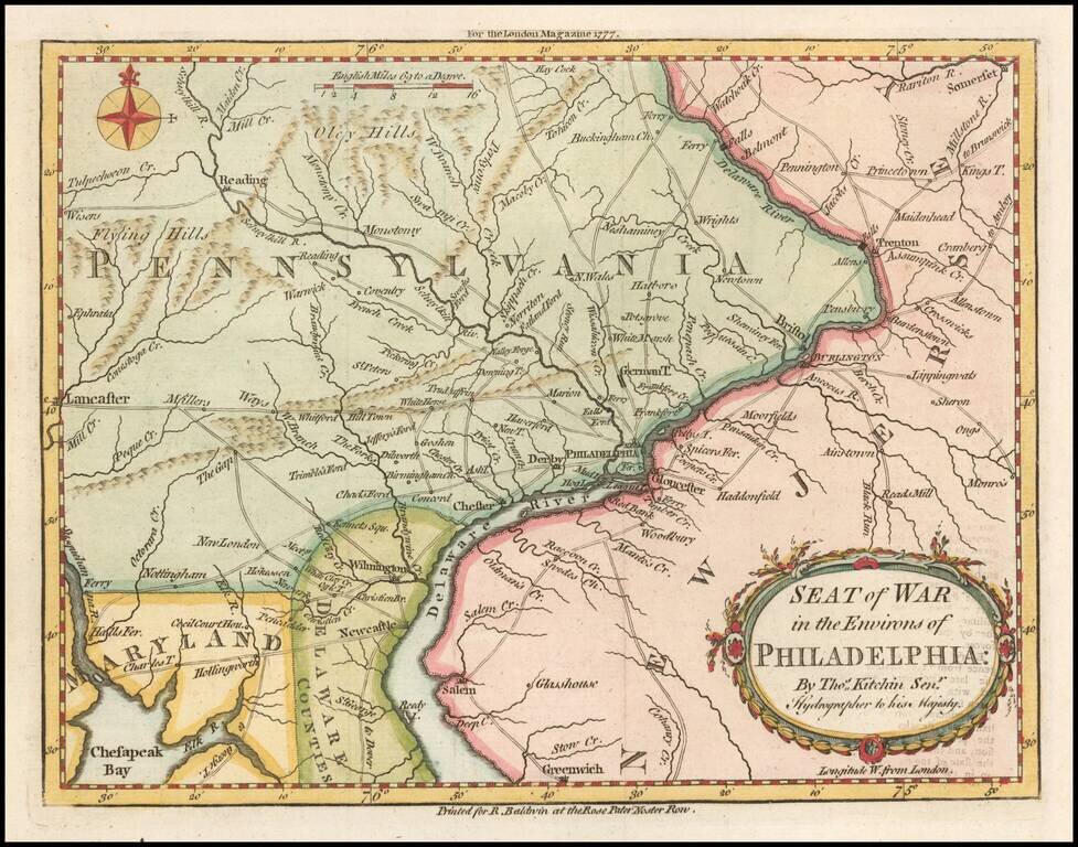
Fine early map showing the Seat of the American Revolutionary War around the Delaware River and Philadelphia, which appeared in the London Magazine in 1777. The map includes the area from Trenton to Lancaster. The road network is shown in detail. It...
![[Long Island Sound from Hampstead Bay to Huntington Bay]](/map/small/51310.jpg)
Rare Des Barres chart of Long Island Sound, covering the coast of the north shore of Long Island roughly from Hampstead Bay to Huntington Bay, and including Oyster Bay and Cold Spring. The present chart constitutes a partial section of Des Barres's...
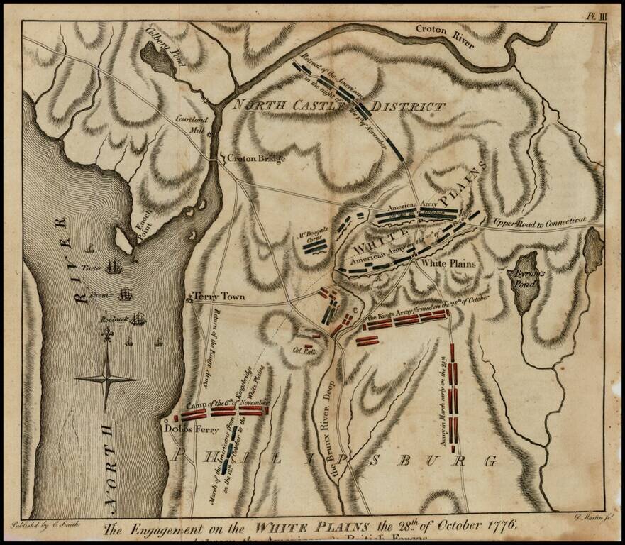
Rare Revolutionary War battle plan of White Plains, from Charles Smith's Monthly Military Repository, the first detailed plan of the battle of White Plains to be printed in the United States. Following decisive victories in Brooklyn and Manhattan,...
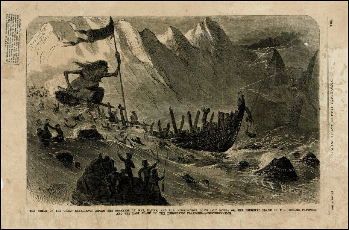
Wood engraved political satire, critiquing the Democratic Party's attitude towards slavery in 1864, the so-called nonintervention policy, which held that the Union should not interfere with slaves, particularly those who found their way to Union Army...
![(Second World War - Normandy Campaign) Cherbourg - Rennes | Adm. Map A To Accompany Administrative Instructions No 1 Hq. Normandy Base Section Hqs. Com[munication] Z[one], E[uropean] T[heater] [of] O[perations] U[nited] S[tates] A[rmy]](/map/small/61727.jpg)
Rare Normandy Campaign Overprint Map Showing The Development of Allied Control of the Area Early in the August 1944 Breakout From Normandy. United States Army map of the Cotentin Peninsula illustrating the military administration of the area, in the...
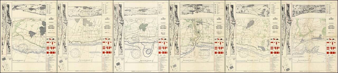
A Complete Set of TOP SECRET Landing Maps For Okinawa Produced in the Lead Up to the Invasion. Six color-printed sheets (of six, i.e., complete), showing all of the American landing beaches on Okinawa. Each sheet is composed of ten frames: the...
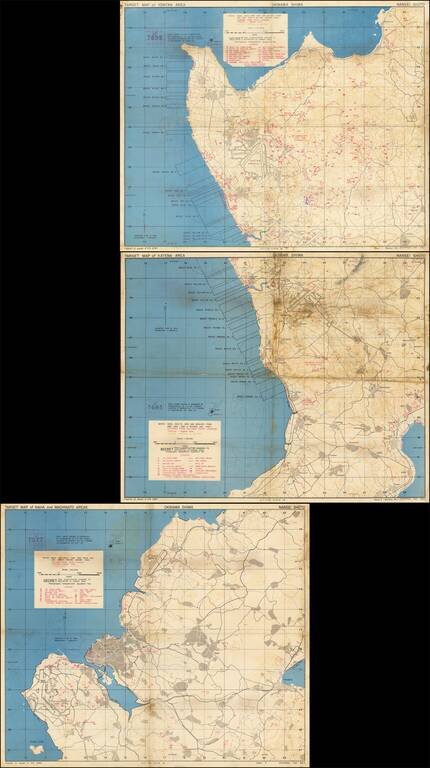
Immediate Pre-Invasion, SECRET Map Set Showing the Landing Beaches and Defenses on Okinawa. Fantastic set of three color-printed maps (the complete set) "prepared at the request of 10th ARMY" showing the west coast of Okinawa and the extent of the...
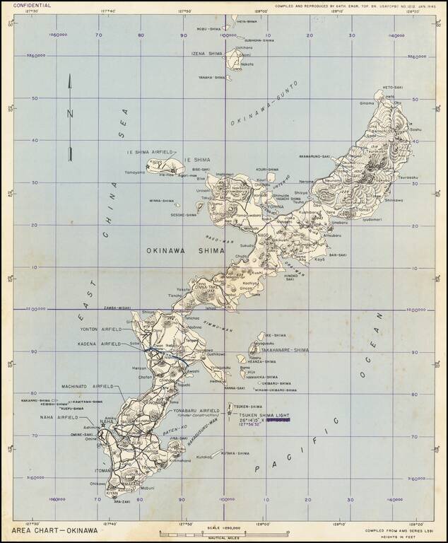
This is a military chart showing Okinawa in detail, with a particular focus on the military installations of the island. The map depicts the island in full, along with some nearby islands including Ie Shima and Iheya Shima, some of which would also see...
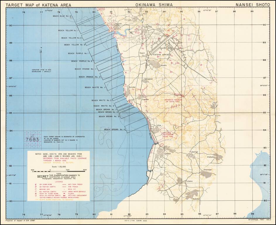
Immediate Pre-Invasion, SECRET Map Showing the Landing Beaches (Blue No. 2 through Brown No. 4) and Defenses on Okinawa. Fantastic color-printed map "prepared at the request of 10th ARMY" showing the west coast of Okinawa and the extent of the U.S....