Map size in jpg-format: 115.728MiB
Click to open in high resolution (open in new tab).
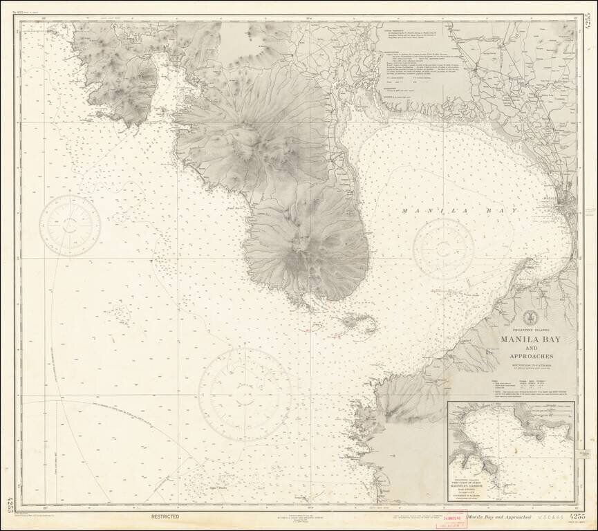
"RESTRICTED" World War II Map of Manila.
Detailed chart U.S. Coast and Geodetic Survey (Philippine Divison) of Manila Bay, including Corregidor Island, originally published before the Japanese takeover during the early stages of the Second World War in the Pacific.
The map bears a red stamp of the Hydrographic Office of the Navy Department, dated 16 April 21 '45. This dates this printing of the map to just after the Battle of Manila.
On December 7th, 1941, Imperial Japanese forces invaded the Philippines, and had previously been a dream assignment for members of the C&GS turned into a nightmare; the head of the Philippine Bureau at the time, Commander George Cowie, died in the Japanese bombing of Manila on the 24th of December when a bomb struck the C&GS printing plant. When Manila and the rest of the Philippines ultimately fell, C&GS officers and their families became prisoners of war.
The C&GS had moved chart production to Manila in 1920, where the first edition of this chart was printed in 1940, but due to the war, production had to be moved back to Washington, D.C. That move is alluded to in the lower corner of this map, which reads "Special Printing at Wash. D.C. 42-2/5, 6/16; 44-4/21, 7/13".
An inset map showing Mariveles Harbor is titled "Philippine Islands West Coast of Luzon Mariveles Harbor... Surveyed in 1918"
If you are a student, write to us in telegram: @antiquemaps and indicate what material you need and for what work you need a map in high detail. We are ready to provide material on special terms. For students only!
![[Martin Behaim Globe / Book] Pars Globi terrestris Ao. 1492 a Martino Behaim Equite Lusitano Norimbergae confecti Delineavit Christoph. Theoph de Murr 1778 (bound with:) Diplomatische Geschichte des Portugesischen berühmten Ritters Martin Behaims](/map/small/68828.jpg)
![Il Disegno Della Terza Parte Dell' Asia [Gastaldi's Wall Map of SE Asia with extra panels!]](/map/small/30554hbp.jpg)
![Chinae, olim Sinarum regionis nova descriptio. auctore Ludouico Georgio. [English Edition!]](/map/small/71123.jpg)