

Rare Dutch edition of this highly important map the region, from Pike's account of his expedition to the West . The map shows Pike's route through the region from the west of the Mississippi, from the Missouri River to the Red River, and extending...
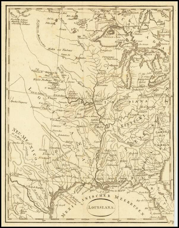
An Early Louisiana Purchase Map Extremely rare little map centered on the Mississippi, apparently based upon the map used to illustrate Berquin-Duvallon's Vue de la Colonie Espagnole du Mississippi, ou des Provinces de Louisiane et Floride...
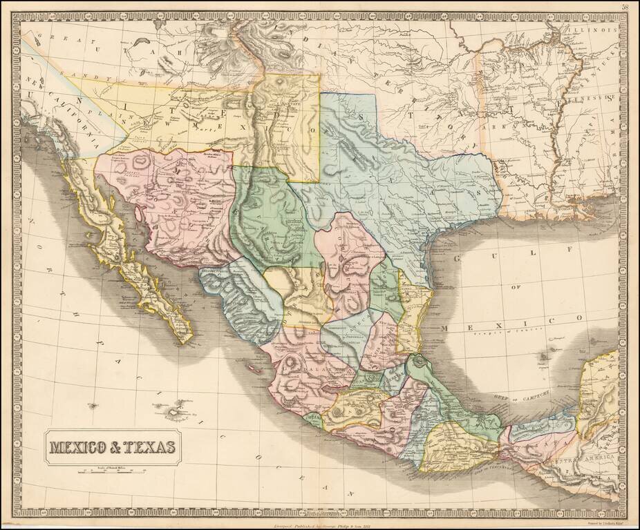
Rare map of Mexico, Texas and the Southwest, from an early edition of Philip's Imperial Atlas. This map is issued shortly before the Gadsden Purchase, and shows a very oddly configured Texas, bounded by a massive Indian Territory and New Mexico...

The Neutral Lands and the Race To Construct Railroad Lines from Northern Kansas to Indian Territory Unrecorded railroad map of Texas, the Southern and Mdiwestern States, published by the Missouri River, Fort Scott & Gulf Railroad and the...
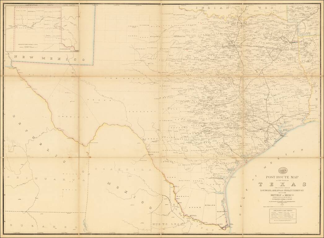
A Texas Sized Postal Map Without Post Routes! First state of this important early map showing the Official Post Offices and Postal Routes in Texas in the last decade of the 19th Century. The Key indicates that the map include Railroads, Mail...
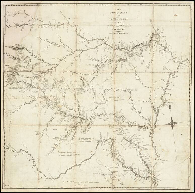
A Foundational American Map An exceptional Trans-Mississippi West map, showing the first portion of Zebulon Pike's exploration of the American Southwest. The map shows Pike's route through the region from the west of the Mississippi, from the...
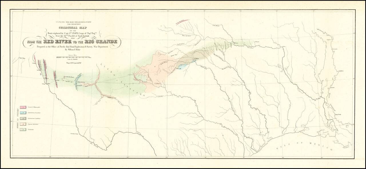
Finely executed Geological Map, centered on Texas and published in conjunction with search for the most practicable route for a railroad line to the Pacific Ocean. Nice example of William Phipps Blake's geological railroad survey of the region between...
![[Texas and Western Louisiana]](/map/small/66617.jpg)
Highly detailed map of a large part of Texas and Louisiana, prepared as part of the US Government's monumental work Atlas to accompany the official records of the Union and Confederate armies, published between 1891 and 1895. The map extends west to...
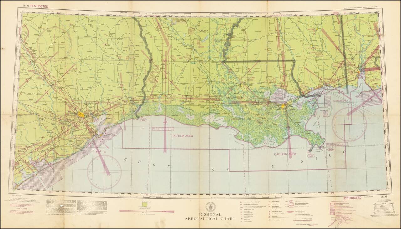
Restricted World War II Aviation Map Detailed aeronautical map Eastern Texas, Southern Louisiana and Southern Mississippi, prepared by the US Department of Commerce. This is an early chart on a Lambert Conformal Conic Projection. The chart is a...
![[Restricted] New Orleans (0-6)](/map/small/68648.jpg)
A great World War II [Restricted] map of the Gulf Coast spanning from Beaumont in Texas to Gulfport in Mississippi. The map focuses on aviation in the area, showing sensitive civilian and military corridors. Civilian flying is restricted along a large...
French edition of Stephen Long's seminal map of the region drained by the Arkansas, Kansas, Missouri and Mississippi Rivers, one of the most important maps of the American West. Stephen H. Long led a government expedition to the Rocky Mountains in...
Antique Map of Texas, Mexico and the American Southwest, Florida and the Caribbean Scarce map of the Southwest, Caribbean and Gulf Coast, from De Vaugondy's Nouvel Atlas Portatif. Includes a marvelous contemporary cartographic representation of the...
![Americque Septentrionale Par le Sr. Sanson d'Abbeville Geographe du Roy . . . 1705 [Rare Peninsular California edition, with unusual Mississippi River depiction]](/map/small/61024.jpg)
Antique Map of North America -- California as an Island Old color example of Sanson's revised map of North America. In 1705, Pierre Moullart Sanson radically revised this map of North America, modifying perhaps the three most significant features of...
![Nuovo Messico appartiene alla Spagna [with] A. Luisiana Inglese B. Luisiana Francese](/map/small/7075.jpg)
Extremely rare pair of miniature maps on one sheet, from a miniature Italian Atlas. The first example we have ever seen. The upper map extends from Baja California and the Pacific to Texas, centered on the Rio Grande. Full of very curious place names....
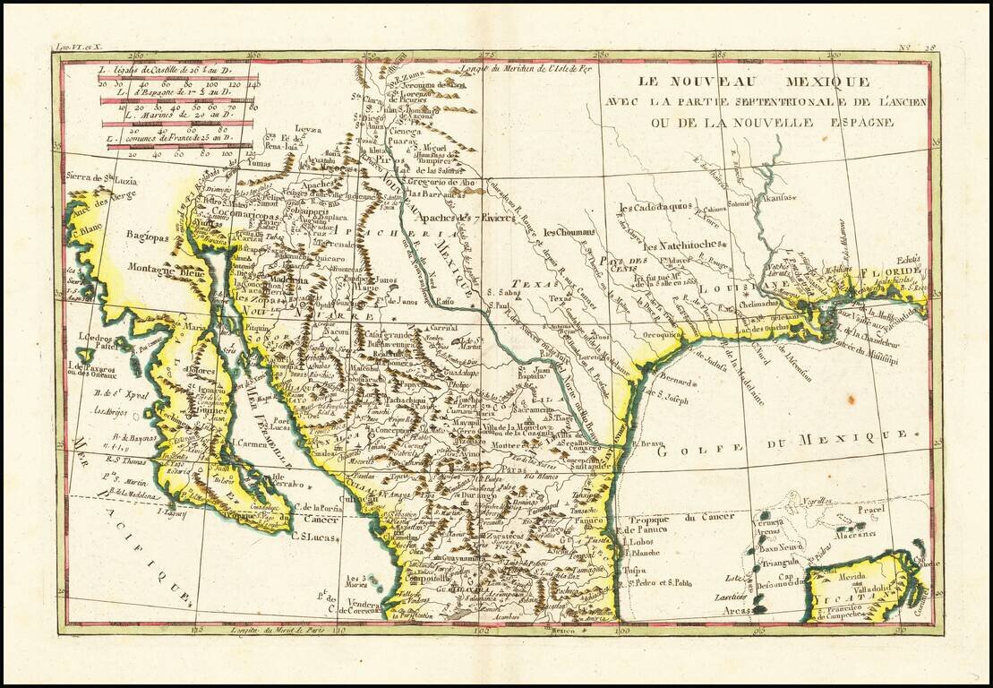
Fascinating map, showing excellent detail in Texas, Arizona and New Mexico. Includes a badly misprojected Baja California, as was normally the case with French maps of the period. Missions and settlements shown in the Texas interior. Indian tribes...
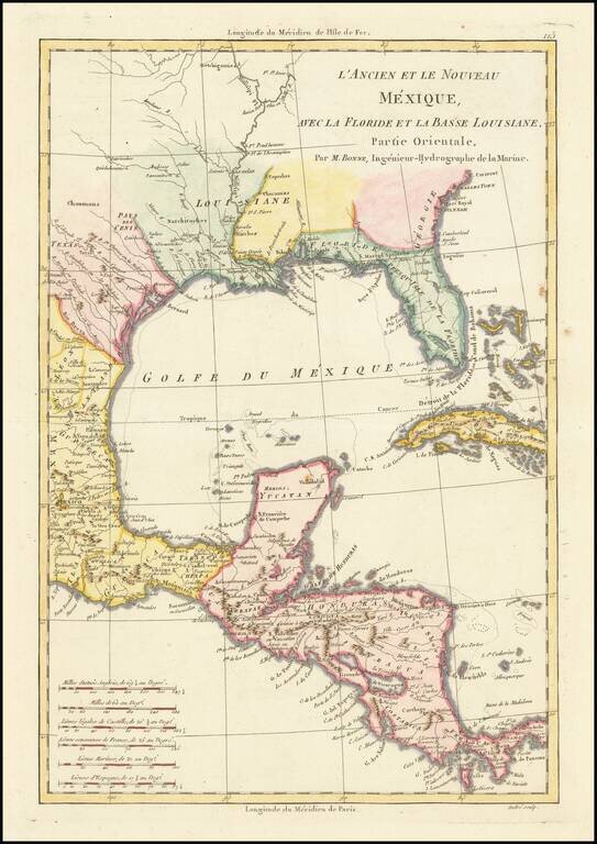
Excellent colonial era map of the Gulf Coast, Florida, Texas and Central America, with the Western part of the Caribbean. Nice detail in Florida and Texas. Attractive wash colors. From Bonne's Atlas Supplement, published in Paris in 1787.