Map size in jpg-format: 39.1615MiB
Click to open in high resolution (open in new tab).
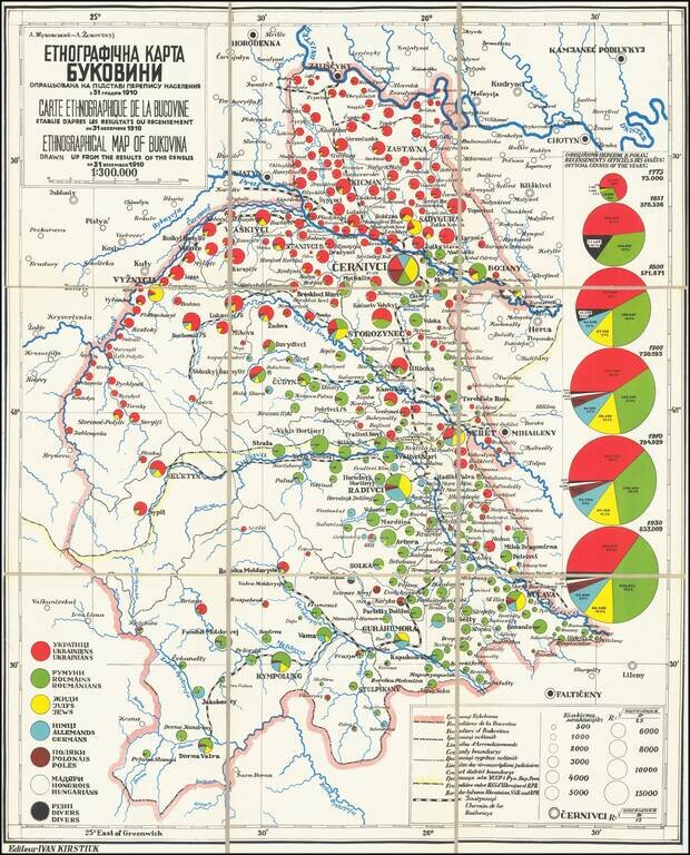
This fascinating map is a rare look into the distributions of various ethnicities through the historical region of Bukovina, prior to the world wars, with insights regarding Jewish history in the region. The map was based on work by the famed Ukrainian geographer Arkadiy Zhukovsky.
The map shows this Eastern European region in detail, with fascinating ethnographic detail. On the right side of the map, the growth of various ethnic groups overtime is tracked, with the populations of ethnic Ukrainians, Romanians, Jews, Germans, Poles, and Hungarians all noted. Evidently the region is very diverse. The map shows the breakdown of ethnicities in every population center with more than 500 residents. The geopolitical situation in Europe in the first half of the twentieth century gives the ethnic distributions shown on this map added importance.
Bukovina is split between Ukraine and Romania on the map, but historically this region was ruled as a joint entity and passed from one European power to the next. The region played an integral part in the rise of both Ukrainian and Romanian nationalism, paving the way for future conflict. Previous rulers had played ethnicities against each other, such as when the Hapsburgs granting privileges to Ukrainians in order to stimy the desire for Romanian independence. This further increased tensions.
The map shows that the country is very diverse, and some geographical patterns emerge. The north of the region is predominantly Ukrainian, and the south is predominantly Romanian. It would be this ethnic division that would provide a reason for the USSR to invade the northern half of the territory, and grant it to Ukraine.
Of course, Ukrainian nationalists were not the only ones who might have used the realities shown in this map to their political advantage. Nazi Germany would have seen the hundreds of thousands of Germans living in the region, particularly in Soviet Cernivci, as a reason for conflict. Finally, the map provides an important look at the distribution of the Eastern European Jewish population immediately prior to World War II. This population was already decreasing in size, likely due in part to the Ukrainian pogroms at the start of the 20th century.
This map has been ascribed to the work of the late Ukrainian geographer, Arkadiy Zhukovsky (Francophonized Joukouvsky). Living as an expatriate in Paris, he specialized in studies regarding the ethnic history of Ukraine and was particularly interested in teaching foreigners about the country's history. This likely explains the trilingual nature of the map. Zhukovsky had little faith in the Soviet published material regarding the region and thus supplements them with pre-Soviet sources, citing "conflicting information." This map only includes data up until the Soviet era, showcasing this concern. Zhukovsky had determined that the Austrian survey of 1910 was the most accurate, and chose to use this one to show the distribution of ethnicities throughout the country.
Examples of this map reside in several Bukovian historical societies.
If you are a student, write to us in telegram: @antiquemaps and indicate what material you need and for what work you need a map in high detail. We are ready to provide material on special terms. For students only!


![Europe No. 16. Partie De La Russie D'Europe [Tambow, Woroniege, Saratow and Territoire De La Milice De Don, etc.]](/map/small/19823.jpg)