

Willem Barentsz's Map of the Polar Regions, drawn from his observations during his third voyage of 1596-97 and engraved by Baptiste Van Deutecum. The Barentsz map of the polar regions is a major landmark in Arctic cartography, depicting the details...
![[Spitzbergen & Wiches Lande]](/map/small/61990.jpg)
Mapping the early whaling voyages of the Muscovy Company Scarce early map of Spitzbergen, flanked by nine scenes of whaling, fishing, processing & bear hunting, and walruses (here called Seamorces), which first appeared in Purchas His Pilgrims...
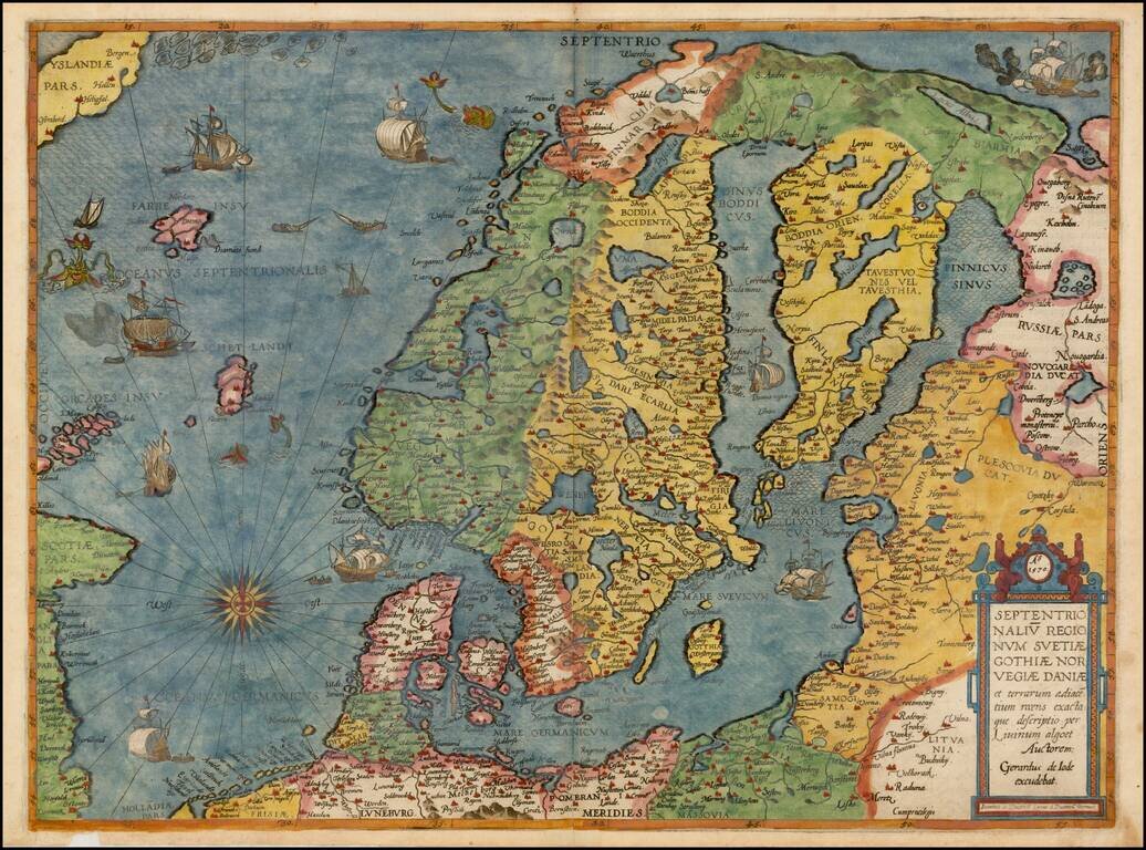
Colored example of De Jode's map of Scandinavia, the Baltic and Gulf of Finland, extending from Iceland and the Coast of Scotland to Novograd, St. Petersburg and the Norwegian Sea. The map is richly engraved by Joannes and Lucas van Deutecum's,...
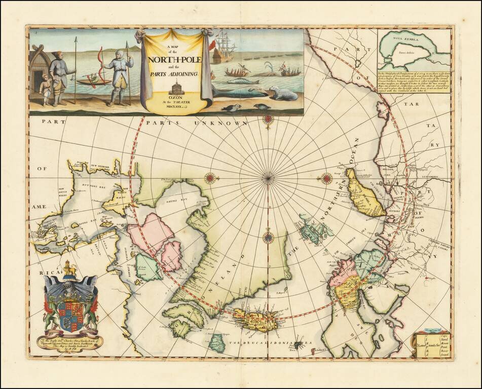
Remarkable Early English Map of the North Polar Regions Fine example of Moses Pitt's original map of the North Pole and surrounding lands. Moses Pitt initially set out to produce an expanded edition of Jansson's Atlas Maior with his partner Jacob Van...
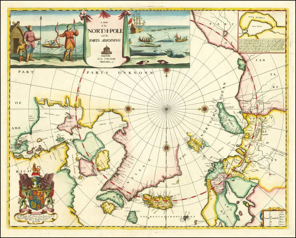
Remarkable Early English Map of the North Polar Regions Fine example of Moses Pitt's original map of the North Pole and surrounding lands. Moses Pitt initially set out to produce an expanded edition of Jansson's Atlas Maior with his partner Jacob Van...
![[Polish Towns in the United States] Ks. Fr. Bolek Osiedla Zalozone Przez Polakow W. Stanach Zjednoczonych / The Towns and Villages Settled By Poles in the United States](/map/small/63071.jpg)
Interesting map of the United States, drawn by Polish historian Franciszek Bolek and published by the Polski Prezglad Kartograficzny (Polish Cartographic Review) in 1930. Franciszek Bolek (also known as Francis Bolek ) was a Polish historian,...
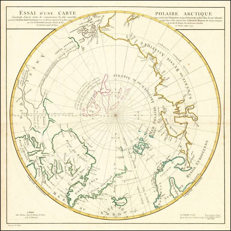
A Cartographic Landmark -- De Vaugondy's Presentation to the French Royal Academy on the Most Practicable Sailing Routes to the Pacific via the North Polar Regions Extremely rare polar map produced to illustrate a presentation made by Didier Robert...
![[Eastern Siberia and Alaska]. ‘Vostochnaya Chast Irtkutskoi Gubernii s prilezhashhimi ostrovami i zapadnom beregom Ameriki’ (‘The Eastern Part of the Irkutsk Province with the adjacent islands and the West Coast of America’).](/map/small/38895.jpg)
Fine example of this rare Russian map of the northwest coast of America and northeastern parts of Russia, published by Wilbrecht in his rare 1792 atlas entitled Ross'iiskoi Atlas iz soroka chetyrekh kart sostaiashch'ii I na sorok na dva...
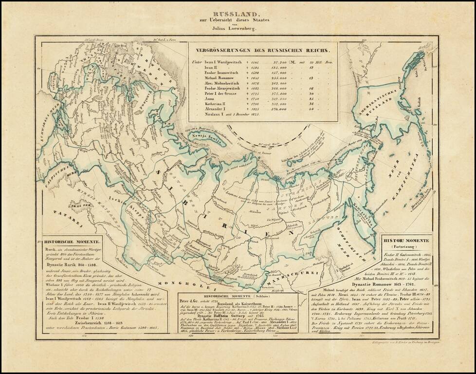
Interesting map of Russia, including Russian America, published in Freiburg in 1839. Includes historical text below the map, covering the history of Russia.
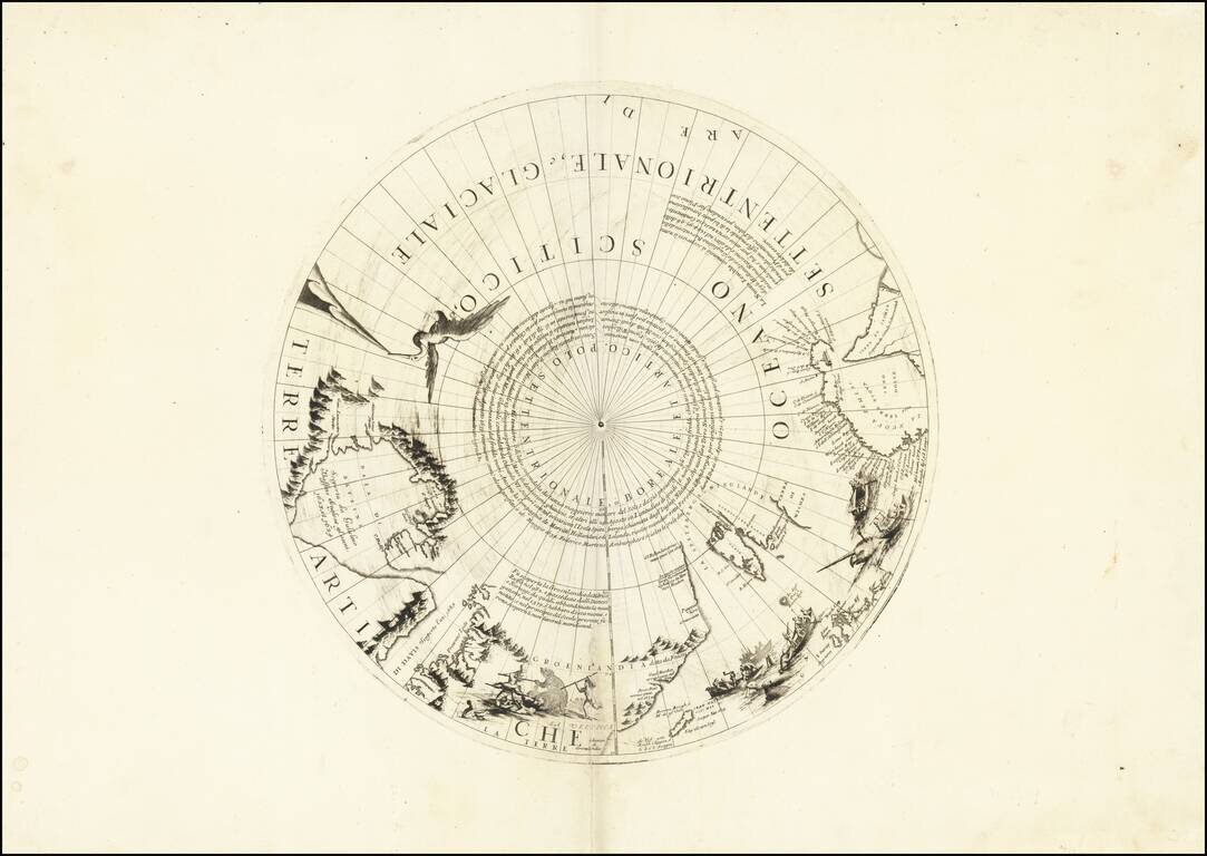
Rare north polar section of Coronelli's remarkable globe gores, first published in 1690. The present gore section is the upper calotte for Coronelli's large (110cm) globe showing the north pole and surrounding areas. The section includes extensive...

Rare edition of Cloppenburg's map of the Holy Roman Empire.
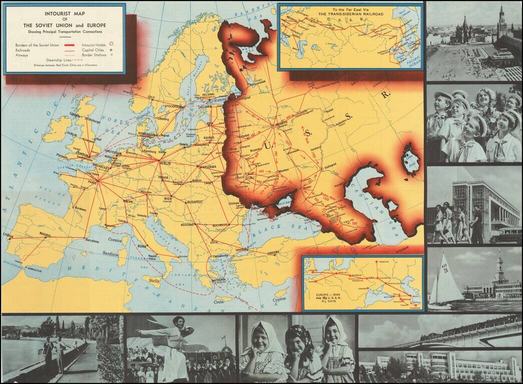
Interesting pictorial map of Europe an the Soviet Union, published by Intourist, promoting tourism in the Russia. The map shows major transit lines and charming monochromatic photos, with the verso giving different travel itineraries and general...
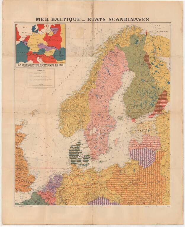
Large format map of the Theater of War in 1940, published in Paris. The inset map shows the German Confederation as it will appear in 1950, based upon a public German document from 1904. The areas identified in Striped regions have already been taken...
![(Second World War - Eastern Front) [Strikes by the Red Army on the Enemy in 1944] Удары Красной Армии По Противнику в 1944г.](/map/small/68414.jpg)
Extremely rare Red Army-published map of the progress of the Second World War on the Eastern Front during 1944. The map shows the extensive gains of the U.S.S.R. throughout late 1943 and 1944, from their nadir, with the Germans at the outskirts of...
![[Stop The Fake News!] Halte au Menteurs! Les Colo Bacilles Sement La Haine!](/map/small/59951.jpg)
Halt The Liars! Stop The Fake News! Rare separately published political broadside, decrying the channeling of Stalinist Russia's lies, fake news and disinformation campaigns via the French Communist Party, after World War II. As described in greater...

Rare Early Map of Northern Europe Important early map of Northern Europe, Scandinavia and the British Isles, which first appeared in the 1507-1508 Rome edition of Ptolemy's Geography, Claudii Ptholomei Alexandrini. Cosmographia..., created under the...