Map size in jpg-format: 36.6473MiB
Click to open in high resolution (open in new tab).
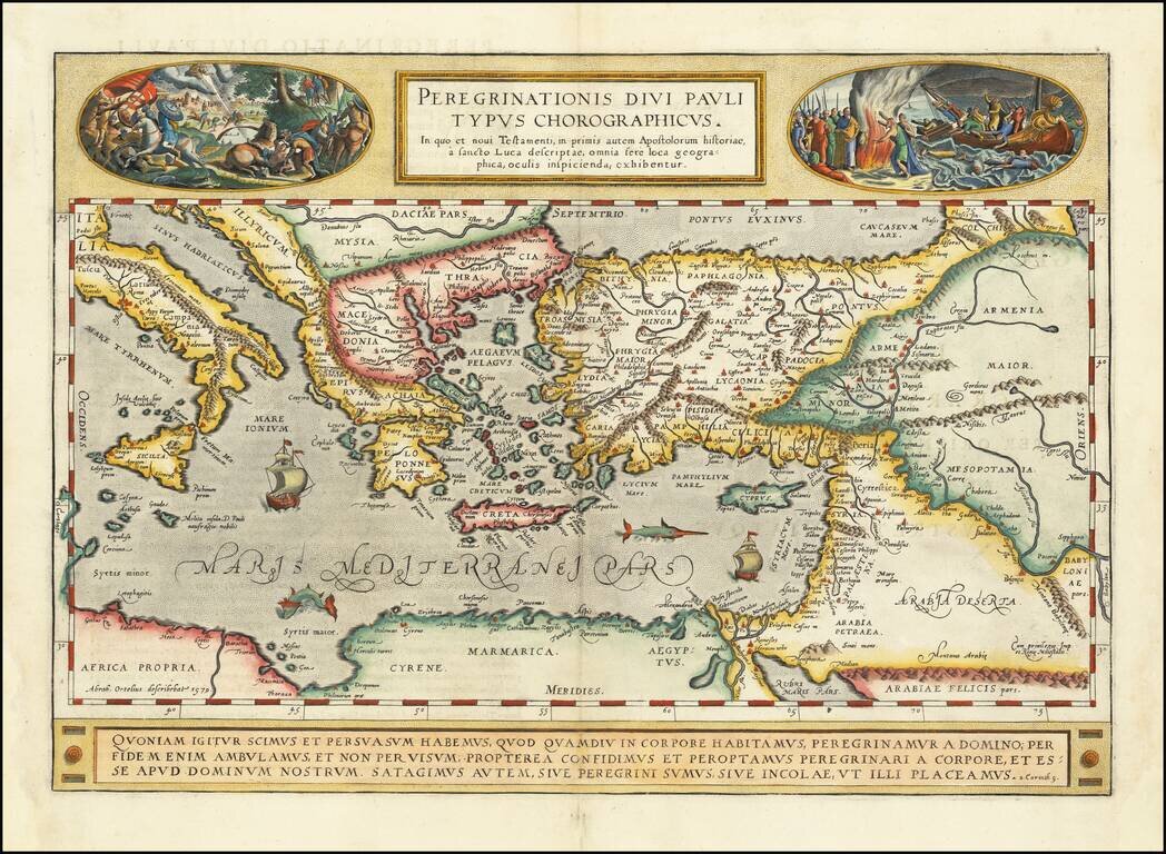
A gorgeous example of Ortelius' map of the travels of St. Paul the Apostle through the Mediterranean, extending west to Italy and east to the Euphrates, including parts of the Red Sea and the Black Sea. Several sailing ships and sea monsters in the Mediterranean.
Ortelius titles this work with an apology that this map is not as detailed as others of Palestine and the Eastern Mediterranean, but that he preferred to focus on place names which had New Testament significance. The map labels many of the cities of the modern and Roman eras in the large area where Paul was believed to have exercised his ministry. The map shows all the places of interest in the life of Paul: Damascus, where he was converted, Malta, where he converted the local populace, Corinth, the city to which he wrote his epistles, Rome, where he died, and many more. Interestingly, these places are not explicitly associated with Paul's life in the map.
Two ornate scenes from St. Paul's travels are illustrated with unusual detail. They depict the two major conversion scenes in Paul's life: first when he is converted, and second when he converts the inhabitants of Malta. Paul's conversion occurred while he was on the road to Damascus, persecuting the new Christians. Having fallen from his horse, he was blinded for three days before Jesus appeared to him, and he converted. We see this on the left. In the right-hand side image, we see Paul bitten by a viper while lighting a fire and surviving after having been shipwrecked. This act of survival was enough to convince the local population to convert.
At the bottom of the image is a quote from Corinthians which scholars and theologians attribute to Paul. In his two epistles, Paul describes what he saw while in Corinth and the various ways in which the inhabitants strayed from the path that Jesus had set forth. This particular verse written in Latin details that as the true believer walks by faith and not sight, they make it their aim to please the Lord whether at home or abroad. This was a key verse for pilgrims and exemplifies the difference between spatial and spiritual pilgrimage.
This work was published in Ortelius's Parergon sive veteris geographiae aliquot tabulae, which featured the areas traveled by famous figures of the ancient world. Five maps are devoted to sacred history, and those regarding the travels of Abraham, Moses, and Paul are the best known in this series.
Ortelius's Parergon
Although best known for his world atlas, the Theatrum Orbis Terrarum, the Parergon was a project of personal interest and the work that Ortelius himself considered his greatest achievement. He had a deep interest in classical antiquity which spurred him to create the Parergon maps, and the amount of time and detail he put into each map is clearly evident. Ortelius hand drew each map of the Parergon, which required considerable skill and knowledge of the area’s history and geography. It is considered the first historical atlas.
Parergon means supplementary and, accordingly, the first three Parergon maps were published as supplements to the 1579 edition of the Theatrum, which had already been in print for nine years. Over time, successive editions of the Theatrum were supplemented with more Parergon maps, and there are 55 known plates overall. The Parergon was also published as its own atlas separate from the Theatrum on two occasions, once in 1595 and again in 1624.
The Parergon was highly successful both as a supplement to the Theatrum and on its own. It was variously translated into French, German, Italian, and English and regularly printed until 1612. Further editions were more sporadic but still popular, such as the 1624 edition which was published twenty-six years after Ortelius’ death in 1598.
The impressive weaving of myth and history has created a beautiful map, and the level of detail present speaks to Ortelius’ skill as a mapmaker. This map would be a valuable addition to a collection of Italian or Mediterranean maps, Ortelius maps, or maps of classical antiquity.
If you are a student, write to us in telegram: @antiquemaps and indicate what material you need and for what work you need a map in high detail. We are ready to provide material on special terms. For students only!

![Patriarchatus Antiocheni Geographica Descriptio . . . [shows Cyprus]](/map/small/54177.jpg)
