
Rare old maps of the United States.

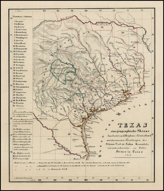
A German Map of the Republic of Texas Detailed map of the Republic of Texas at the start of the Mexican War. The massive stovepipe configuration is shown here, extending to Wyoming in the north, the Rio Grande in the west and the Red River and...

Including Manuscript Additions of the Overland Route To California and Other Important Points. Nice example of Mitchell's seminal map of Texas, Oregon, Upper California, Missouri Territory and a massive Indian Territory (covering most of Kansas and...
Extremely rare map of Texas, not listed in Day, Phillips, Streeter, Taliaferro, or any other Texas reference. While the map is unrecorded and its source is unknown, we are of the opinion that the map was printed, but ultimately never included in a...
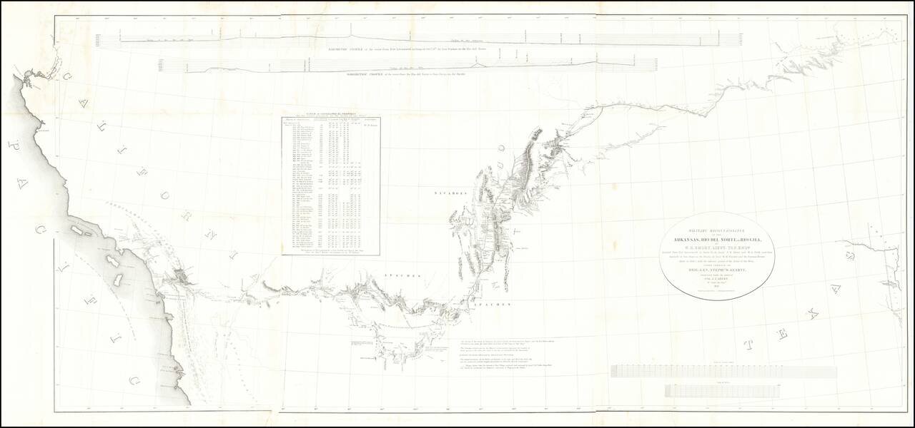
Fine example of the William Emory's milestone mapping of the Southwestern United State, from Ft. Leavenworth to the West Coast, from Emory's Notes of a Military Reconnaissance, from Fort Leavenworth, in Missouri, to San Diego, in California . . ., one...

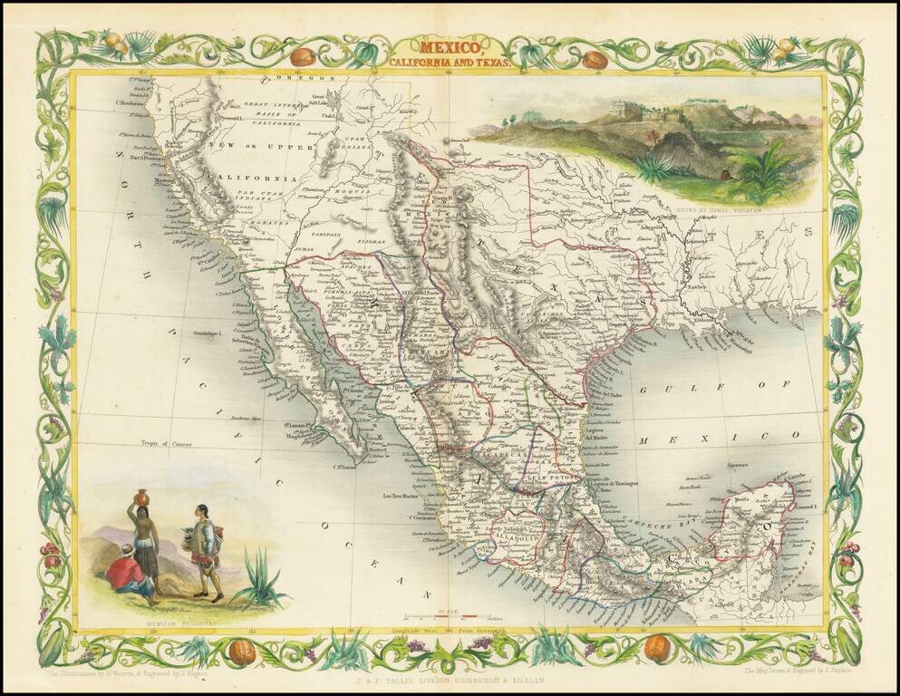
Excellent map of California, Mexico, Texas and the Southwest, published by A&C Black. The map covers all of Upper California and shows the missions, early forts and information immediately prior to the discovery of gold. Several settlement and...
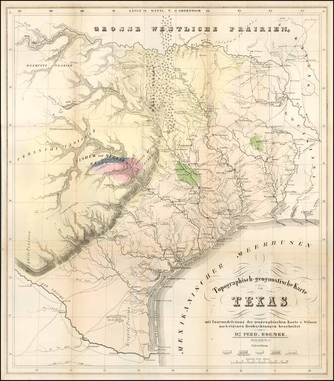
The First Geological Map of Texas An unusually fine example of this important early geological map of Texas by Ferdinand Roemer, published by Adolph Marcus and lithographed by Henry & Cohen, in Bonn. Roemer's map is the first geological map of...
![A New Map of Texas Oregon and California with the Regions adjoining Compiled from the most recent authorities... 1849 [Very Rare Variant Edition]](/map/small/60784.jpg)
Exceptionally Rare Gold Rush Variant of Mitchell's Famed Map of Texas, Oregon, and California. With Mitchell's Guide to California. Antique map of the American West by Samuel Augustus Mitchell. This is an example of the extremely rare 1849 edition,...
An Extremely Rare German Emigrant Guide to California, Oregon, Texas, Iowa and the Midwest -- Especially So With All Maps & Plans Second extended German edition, adding the view of St. Louis and with the often missing maps of Iowa and the United...
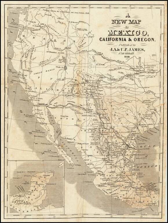
Scarce map of Texas and the West, published in Cincinnati. In Oregon Territory, a number of early American Forts are shown, along with Astoria and Oregon City. To the south, the Gold Region is shown in California, limited only to the area north of...
![Map Of Route pursued by U.S. Troops from Fort Smith, Arkansas, To Santa Fe, New Mexico, via south side of Canadian River In the Year 1849 Whilst serving as an Escort to a party of California Emigrants. . . . [bound with:] Map, No 2... [and:] Map, No. 3...](/map/small/70778.jpg)
Along the Canadian River, through the Texas Panhandle, to Santa Fe, New Mexico. Fine four-sheet map of the overland exploration and survey map, undertaken by the United States Troops at the start of the Gold Rush. In 1849, shortly after gold was...
Rare variant edition of this decorative regional map of the Texas, California and the Southwest, featuring Texas in its Republic configuration, with Stovepipe reaching to Wyoming and Colorado. Upper California is shown with the Gold Regions...
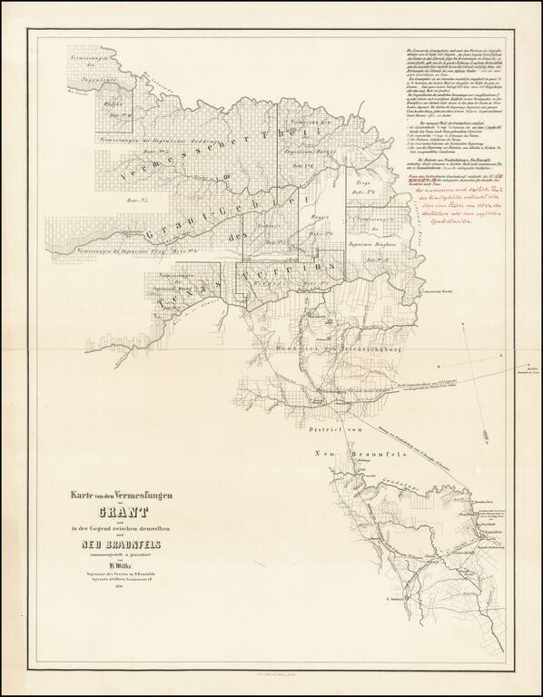
Final Hand-Corrected Proof State? Hand annotated example of this rare Adelsverein map of a part of central Texas, which was then being settled by Texas immigrants under the auspices of the Verein zum Schutze Deutscher Einwanderer Nach Texas (Society...
Rare second edition of the so-called Rosa map of Mexico, first published in Paris in 1837 and re-issued in 1851, at the request of the Congress of Mexico. Rosa's map is perhaps the rarest of the so-called Treaty Map sequence, which shaped the original...
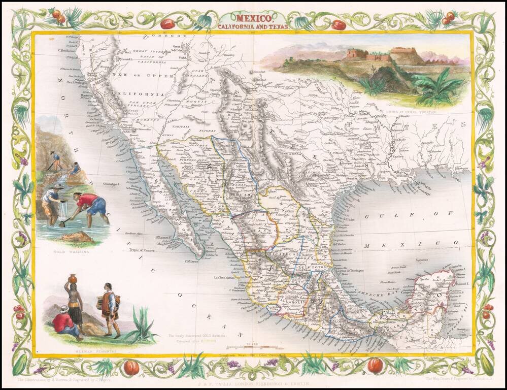
Decorative regional map of the Texas, California and the Southwest, featuring Texas in its Republic configuration, with Stovepipe reaching to Wyoming and Colorado. This is the second edition of the map, which includes the Gold Washing vignette not...
![Karte von Tejas und den angrenzenden Theilen Mejicos . . . [with California Gold Regions Inset]](/map/small/61669.jpg)
Rare Texas Emigrant Map Extremely rare map of Texas, Mexico and contiguous regions, which appeared in volume 6 of Freidrich Heinzelmann's Die Weltkunde in einer planmassig geordneten rundscahu der wichtiigsten neueren Land-und Seereifen für das...
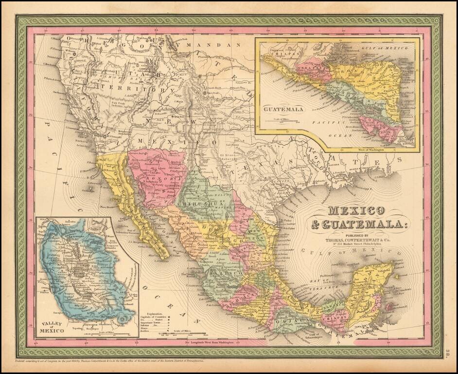
Detailed map of Mexico and the Southwest. Many of the early place names in Texas still appear. Pre-Gadsden Purchase border with Mexico. Large insets of the Valley of Mexico, Isthmus of Tehuantepec, Isthmus of Nicaragua and Guatemala.