
![(Commodore Perry) [Illustration of the Steam Locomotive.] [Jokisha no zu]](/map/small/55566.jpg)
The Miniature Steam Locomotive Commodore Perry Brought to Japan. Woodblock kawaraban print showing the miniature steam locomotive, which is one of the gifts to the Edo government Commodore Perry brought to Japan. The caption says "Gifts from Emperor...
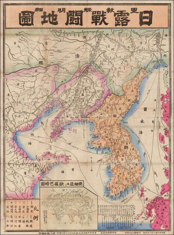
Fine large map of Korea and contiguous parts of China, published in 1904 or Meiji 37. The map was issued during the early days of the Russo-Japanese War (1904-1905), including the Japanese invasion of China and Korea, and the conflict that ensued with...
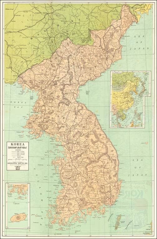
Vintage Korean War-Era map of the Korean Peninsula, published by Geographia Map Co. Inc., in New York City around 1950. The title panel on the verso of the map includes an image of an M46 Patton (?) and G.I.s in a Korean town. The verso includes a...
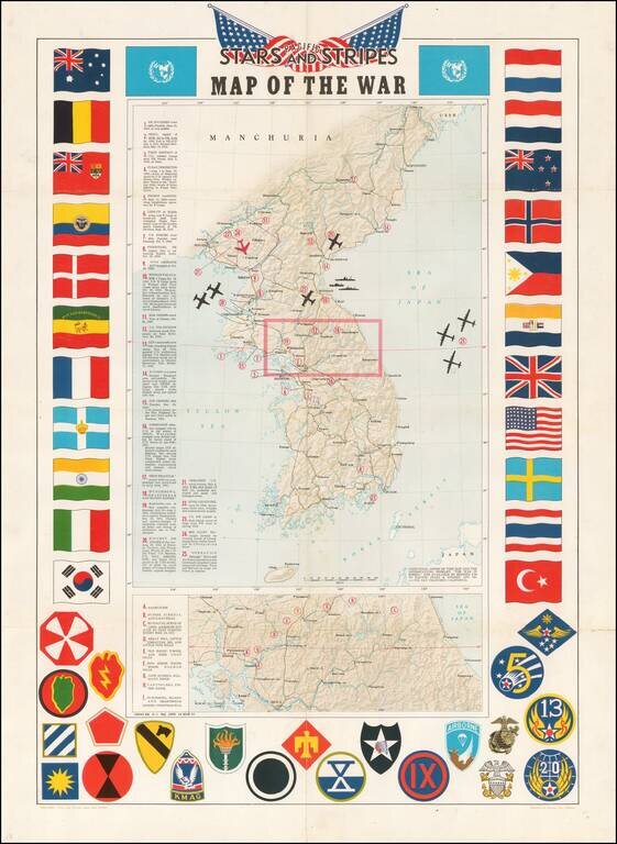
Decorative map of Korea, intended for distribution to soldiers stationed in Korea in the 1950s. Shaded relief with key military features locations marked and described. Includes a decorative border of flags of allies and insignia of military units.
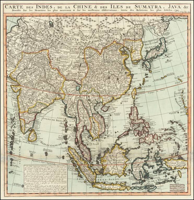
Names the Sea of Korea A large and very detailed map of East Asia, from India and the Indian Ocean in the west to Japan, Korea, and the Philippines. Place names are extensive on this map, both on land and at sea. French text at the bottom describes...
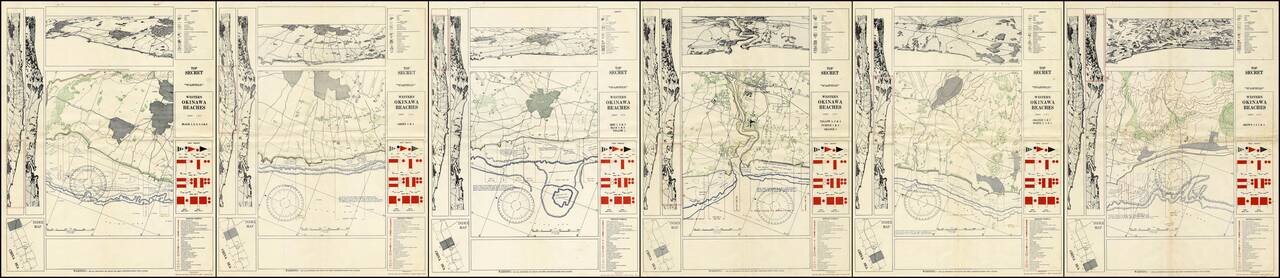
A Complete Set of TOP SECRET Landing Maps For Okinawa Produced in the Lead Up to the Invasion. Six color-printed sheets (of six, i.e., complete), showing all of the American landing beaches on Okinawa. Each sheet is composed of ten frames: the...
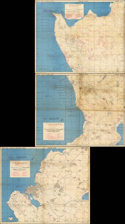
Immediate Pre-Invasion, SECRET Map Set Showing the Landing Beaches and Defenses on Okinawa. Fantastic set of three color-printed maps (the complete set) "prepared at the request of 10th ARMY" showing the west coast of Okinawa and the extent of the...
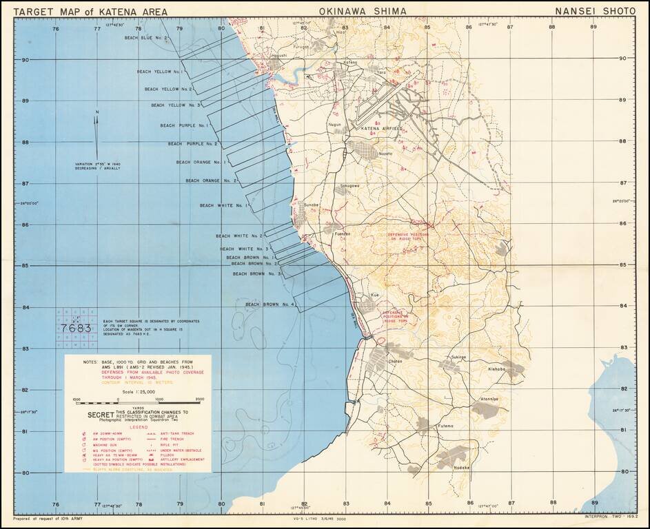
Immediate Pre-Invasion, SECRET Map Showing the Landing Beaches (Blue No. 2 through Brown No. 4) and Defenses on Okinawa. Fantastic color-printed map "prepared at the request of 10th ARMY" showing the west coast of Okinawa and the extent of the U.S....
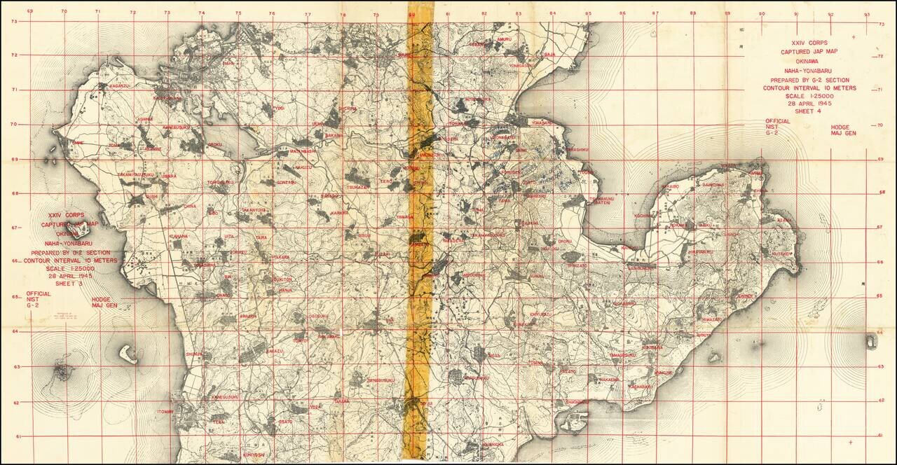
"Captured Jap Map" With Manuscript Additions by an American G.I. Important U.S. military map prepared during the invasion of Okinawa from captured Japanese maps, for use by XXIV Corps. An interesting product of wartime necessity, this map was...
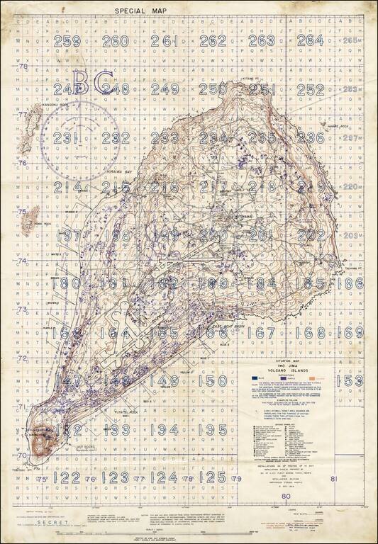
"SECRET" Situation Map of Iwo Jima Detailing the Minutiae of the Japanese Defense of the Island. A rare "Secret" situation map of Iwo Jima prepared in anticipation of the 19 February 1945 U.S. invasion of the island. The map shows the landing zones on...
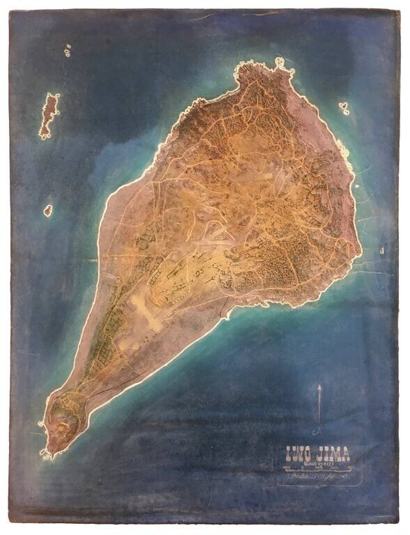
Exceptionally Rare U.S. Military Terrain Model of Iwo Jima, Made in 1945. Foam and rubber terrain model map of Iwo Jima, probably made by the U.S. Navy Reserve group "Building 14", Hawaii, which was in charge of military model making in the Pacific....
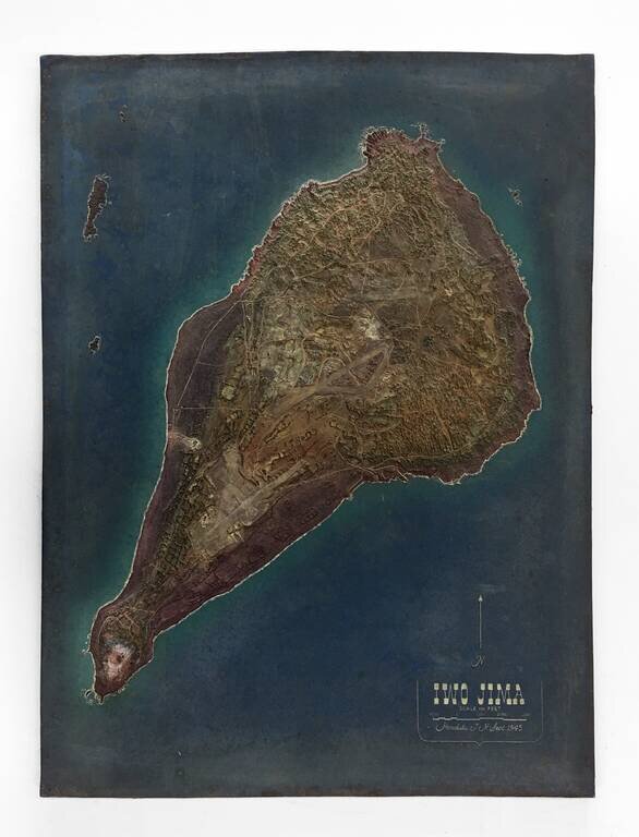
Exceptionally Rare U.S. Military Terrain Model of Iwo Jima, Made in 1945. Foam and rubber terrain model map of Iwo Jima, probably made by the U.S. Navy Reserve group "Building 14", Hawaii, which was in charge of military model making in the Pacific....
![(Second World War - Iwo Jima) Beach Diagram Southwestern Beaches, Iwo Jima Information Taken from Aerial Photographs of 4 July 1944... [with] Becah Diagram Southeastern Beaches, Iwo Jima Beach Information taken from Aerial Photographs of 4 July 1944...](/map/small/62967.jpg)
"SECRET" Beach Diagrams used for Planning and Executing the American Landings on Iwo Jima. Two very rare color-printed views of the southern beaches of Iwo Jima, the southwestern section of which served as a potential landing area for the U.S. Marine...
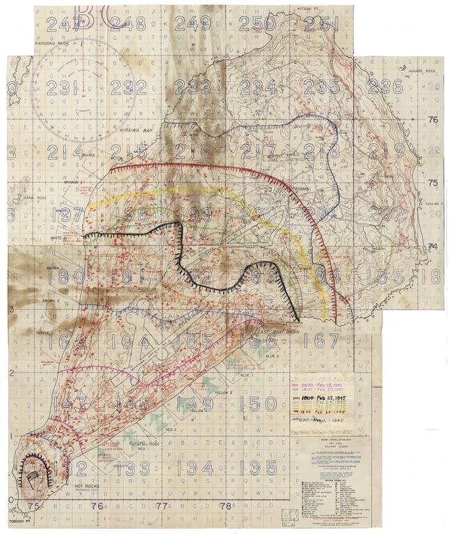
Secret Enemy Installation Map of Iwo Jima prepared for the American invasion, heavily annotated to show the progress of the battle. A rare “Secret” map of Iwo Jima, issued little more than a week before February 19, 1945 U.S. invasion. The map...