
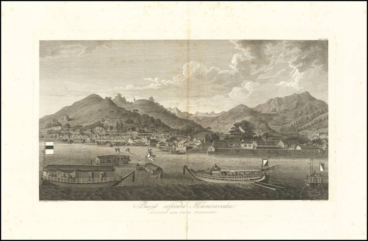
Magnificent View of Nagasaki From the Original Russian Edition of Krusenstern's Important Atlas Fine example of this skillfully-engraved view of Nagaski, based upon drawings taken by Wilhelm Gottlieb Tilesius in 1804-5, which appeared in the atlas to...
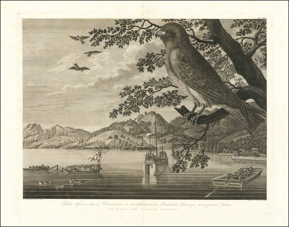
Magnificent View of Nagasaki Coast and an Osprey From the Original Russian Edition of Krusenstern's Important Atlas Fine example of this skillfully-engraved view of Nagaski coastline and an Osprey, based upon drawings taken by Wilhelm Gottlieb...
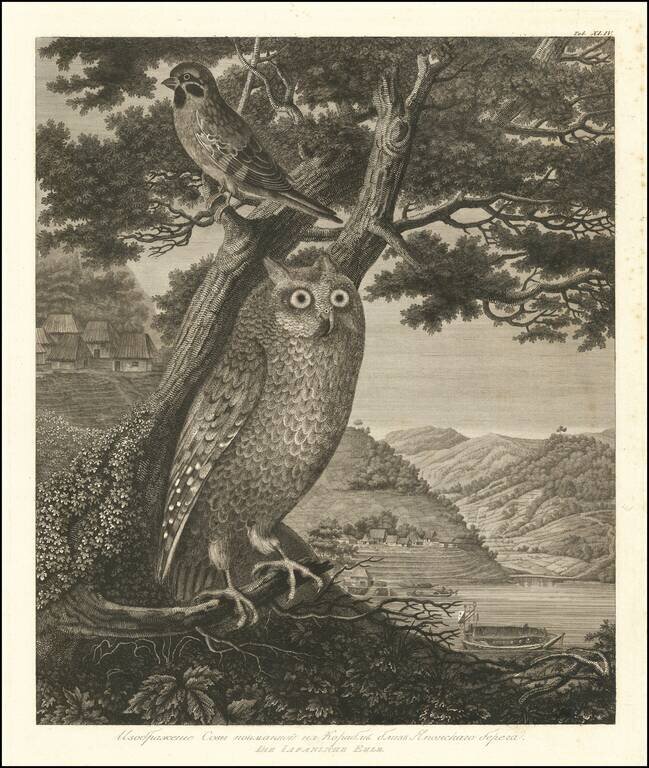
Magnificent Natural History Engraving of an Owl and Sparrow on the Japanese Coast. Fine example of this skillfully-engraved image of an owl and sparrow set against the backdrop of the Japanese coastline. The engraving is based upon drawings taken by...
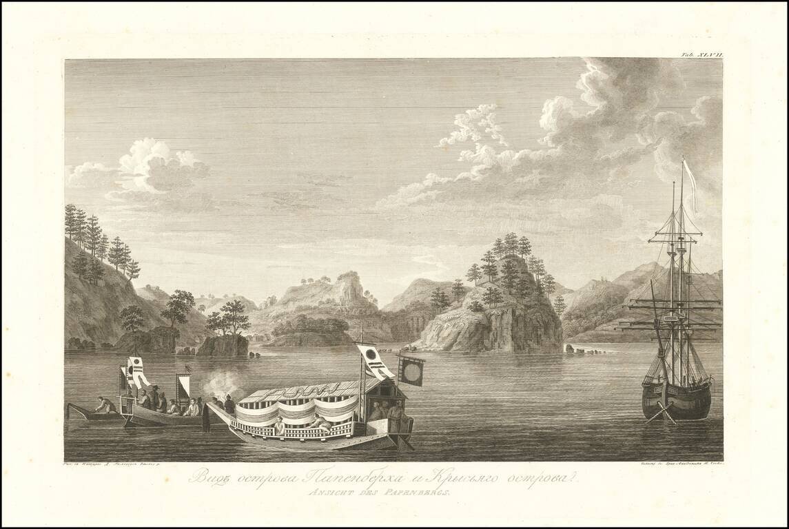
Beautiful View of Papenberg Island and Nearby Coastlines, from the Original Russian Edition of Krusenstern's Important Atlas Fine example of this skillfully-engraved view of Papenberg Island on Russia's Pacific Coast, based upon drawings taken by...
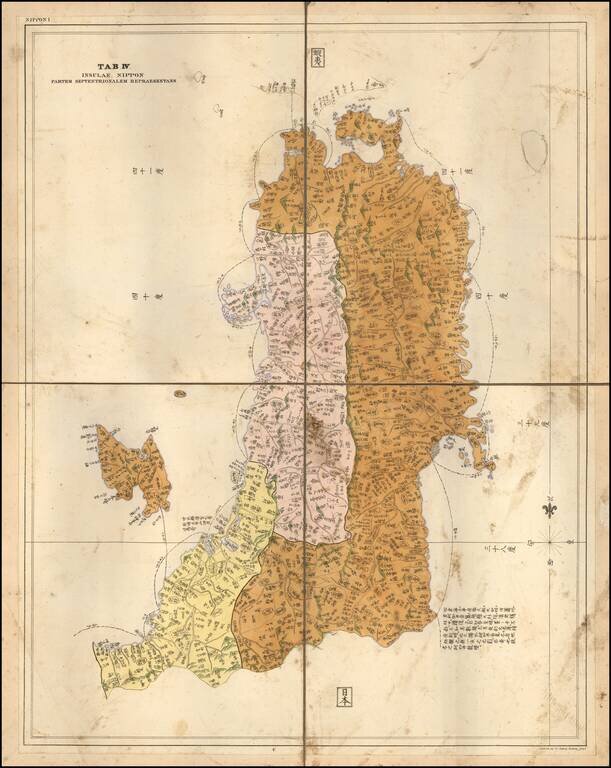
Rare Separately Published Example of the Map of Part of Honshu, by German physician and traveler Philipp Franz von Siebold. Fine map of the most northern part of Honshu, including Fukushima, the island of Sado island. One of the few large scale maps,...
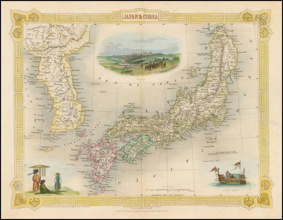
Striking full color map of this decorative map of Japan and Korea, with vignettes of Yedo, a State Barge and Coreans. Engraved for R. Montgomery Martin's Illustrated Atlas. Tallis was one of the last great decorative map makers. His maps are prized...
![(Commodore Perry's Arrival in Edo Bay.) [Foreign Ship | Defence on Land and Sea] [lkokusen | Kairiku okatame]](/map/small/55558.jpg)
Commodore Perry's Fleet Arrives in Edo Bay. A large double-page two-sheet kawaraban with a fold along the left edge. The upper section of this image is a list of the officials responsible for coastal defense. The lower right side shows an American...
![[Concerning the Revised Locations of the Officials Assigned to Coastal Defence] [Kaisei kairiku okatame basho ni tsuki]](/map/small/55559.jpg)
Large double-page two-sheet kawaraban illustrating coastal defense against foreign navies. Published in the wake of Commodore Perry's arrival in Japan. The upper section of the kawaraban lists the officials assigned to coastal defense duty. The...
![(Commodore Perry) [Clans Assigned to Defence Duty on Land and Sea for Maintaining Peace] [Kairiku okatame taihei kagami]](/map/small/55561.jpg)
Japanese Coastal Defense Against Foreign Navies. With a Depiction of Commodore Perry's Fleet and Flagship. This double page kawaraban map shows the officials responsible for coastal defense in lzu, Saga mi, Musashi, Kazusa, Shimofusa, and Awa...
![[Clans Assigned to Defence Duty on Land and Sea in lzu, Sagami, Musashi, Kazusa, Shimofusa, and Boshu] (same as Awa) [Provinces for Maintaining Peace] [lzu, Sagami, Musashi, Kazusa, Shimofusa, Boshu Kairiku okatame taihei kagami]](/map/small/55560.jpg)
Large double-page kawaraban showing coastal defense against foreign navies, in the wake of Commodore Perry's arrival in Japan. A large map shows the coastal area in lzu, Sagami, Musashi, Kazusa, Shimofusa, and Awa Provinces with the names of the...
![[Clans Assigned to Defence Duty on Land and Sea in lzu, Sagami, Musashi, Kazusa, Shimofusa, and Awa Provinces] [lzu, Sagami, Musashi, Kazusa, Shimofusa, Awa kairiku okatame]](/map/small/55562.jpg)
Woodcut kawaraban showing the officials responsible for coastal defense in lzu, Sagami, Musashi, Kazusa, Shimofusa, and Awa Provinces.
![[Illustration of the Dutch Ship] [Ransen no zo]](/map/small/55547.jpg)
Popular Japanese Conception of Foreign Naval Power During the Post-Commodore Perry Era. Woodcut kawaraban featuring a handsome illustration of an elaborate Dutch paddle steamer. The text on the upper right indicates distances from Nagasaki to such...
![[On North America. On Europe: Russian Empire, England, and France] [Kita-Amerika no bu. Yoroppa no bu: Teikoku Roshia, lgirisu, Furansu].](/map/small/55549.jpg)
The People in the United States are Brave and Have a Fondness for Learning. Kawraban woodblock sheet of text divided into four bands, each band containing a short description of the United States, the Russian Empire, England, and France respectively....
![[Officials Assigned to Defence Duty along the Shore in Nagasaki] [Nagasaki kaigan okatame oyakunin]](/map/small/55552.jpg)
Woodblock kawaraban plan of Nagasaki Bay. The fan-shaped area in the middle of the image is Dejima where the Dutch were allowed to live and trade with the Japanese authorities. The square land on the left of Dejima is the Chinese quarter with the...
![[Illustration of Foreign Attendants] [lkoku-jin zuishin no zu]](/map/small/55556.jpg)
Woodblock kawraban sheet showing two foreigners, who it seems probable are American sailors, holding an artillery gun and a spear respectively. The names appearing in the text which surrounds the two figures and the coastal scene on the left are the...
![[Illustration of a Foreign Ship] [lkokusen no zu]](/map/small/55557.jpg)
Popular Japanese Conception of Foreign Naval Power after Commodore Perry's Arrival in Japan. Woodcut kawaraban showing a foreign steamship. This print graphically suggests the power of modern western technology to the very concerned Japanese public....