

One of the Earliest Modern Maps of Russia Striking map of Russia, based upon Anthony Jenkinson's rare map of Russia drawn in 1562. The map covers the region from the Gulf of Finland, Lithuania and the Black Sea to the Sur River, Tashkent, the...
![[Europe, Mediterranean, Asia Minor and the Persian Empire]](/map/small/43558.jpg)
Fascinating early map of Europe, the Mediterranean, Asia Minor and part of Persia. The map utilizes a stippled style of oceans most commonly used at the end of the 16th Century by Dutch mapmakers, such as Jodocus Hondius. Unusual projection of the...

Decorative map of the Black Sea Region, with a large decorative cartouche surmounted by the Russian Imperial Coat of Arms. The map extends north to Moscow and Smolensk from Constantinople in the south.
![Il Disegno Della Terza Parte Dell' Asia [Gastaldi's Wall Map of SE Asia with extra panels!]](/map/small/30554hbp.jpg)
Final State of the Gastaldi's Wall Map of East Asia -- The First Great Wall Map of East Asia Fine example of Giacomo Gastaldi's rare 4-sheet wall map of Southeast Asia, China and India, perhaps the single most influential map of the region published...

A Map of Persia From the Golden Age of Dutch Cartography Finely hand-colored example of Willem Janszoon Blaeu's map of Kingdom of Persia. The map extends from the Eastern Mediterranean to Tacalistan and the Indus River and the Dalanguer Mountains and...

Detailed regional map of the mouth of the Ganges and neighboring regions in the Bay of Bengal, illustrating the narrative of Nino da Cunha. Includes decorative cartouche and vignette. The map offered here was used by Vander Aa to illustrate a Dutch...
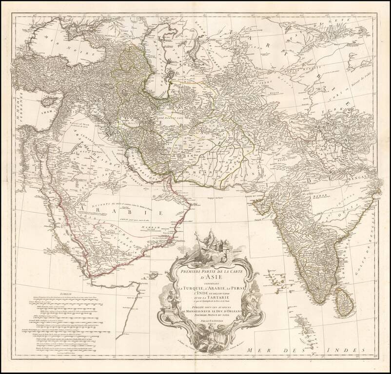
Striking 2-sheet map of the western half of Asia, published by D'Anville. Includes details from Turkey through the Black and Caspian Seas to Tibet and south to include the Arabian peninsula and all of India. Fine detail throughout including the Maldive...
![Northern Hindostan [with] Nepaul [with] Cabul](/map/small/62805.jpg)
Fascinating regional map of Northern India, colored by regions and showing the lands controlled by the British, Nabob of Oude, Berar Rajah, Nizam, Nysore Rajah, Mahrattas, Travancore, and King of Candy. Large insets of Cabul and Nepal. The map of...

Decorative and unusual trading card map from this famous series. Map is surrounded by decorative vignette, showing indigenous scenes.

The Earliest Obtainable Map To Show Houtman's Crossing of the Indian Ocean to the Java, Opening The Spice Trade to The Dutch in 1597. Finely engraved map, showing the route of first Dutch fleet from Zuider Zee to Java in 1596-97, under the command of...
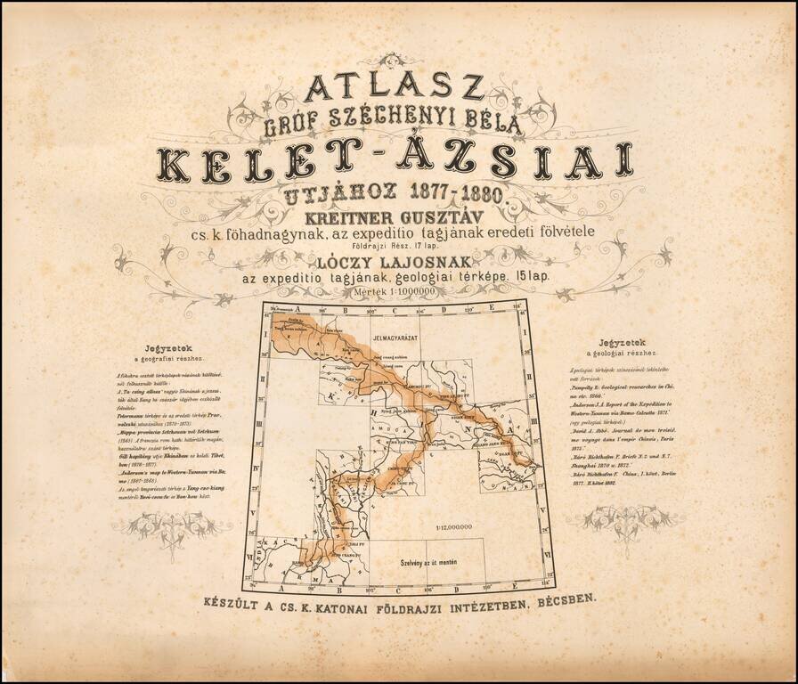
The First Geological Atlas of Tibet Rare geographical atlas of the northern Tibetan Mountains, published in Vienna by the Military Geographical Institute, published to accompany Széchenyi's three-volume account of his travels. From 1877 to 1880...
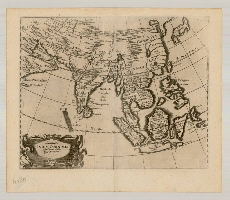
![Undecima Asiae Tabula [India, Southeast Asia]](/map/small/29254.jpg)
First Two-Color Printed Map of Southeast Asia and Surrounding Areas From a Groundbreaking Edition of Ptolemy's Geographia Fine example of Bernardus Sylvanus’ map of Southeast Asia, China, India, and adjoining regions, from his Geographia published...

Gorgeous 16th-century map of the region centered on the Indian Ocean, from Linschoten's Itinerario. Linschoten's work was a significant advance in the mapping of India and the Middle East. As noted by Tibbetts, the surprising fact about the...
![[Rare English Edition!] Deliniantur in hac tabula, Orae maritimae Abexiae, freti Mecani: al. Maris Rubri: Arabiae Freti Mecani: al Maris Rubri: Arabiae, Ormi, Persiae, Supra Sindam usque . . . / The description of the coast of Abex, The Straights of Mec](/map/small/69450.jpg)
Rare 16th-century English map of the region centered on the Indian Ocean, which appeared in the rare English edition of Linschoten's Itinerario, Iohn Huighen van Linschoten. His discours of voyages . . . , published in London in 1598. Linschoten's...
Scarce map of East Asia and the Indian Ocean, extending from Japan and Korea to the Caspian Sea and the Persian Gulf. The map is centered on the Indian Ocean.