
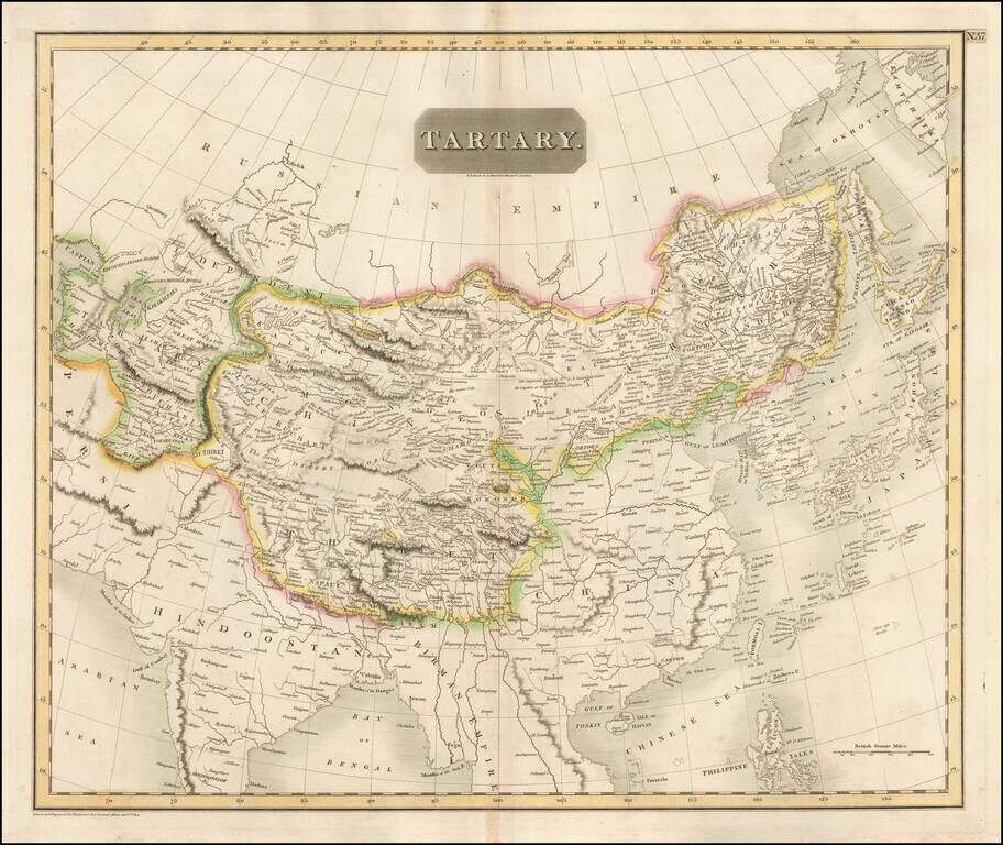
Detailed large format map of Tartary, extending from China, Japan and the Northeastern Russian Regions of Asia to Hindoostan and Beloochistan. One of the most detailed and interesting large format maps of the early 19th Century. A fine example with...
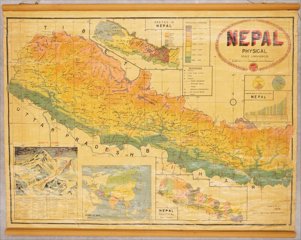
Illustrating Hillary's Ascent of Mount Everest and Prior Failed Attempts Fascinating map of Nepal, issued shortly after Sir Edmund Hillary's Ascent of Mount Everest, including a large inset map / view of the mountain, showing the route of Hillary and...
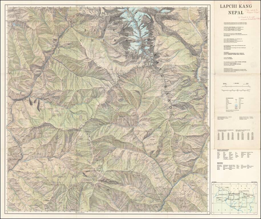
Scarce separately published map of Tibet and a section of Chinese Tibet. The map credits Peter Aufschnaiter as one of its makers. Peter Aufschnaiter (1899 - 1973) was a Tyrolean mountaineer, agricultural scientist, geographer, and cartographer. His...
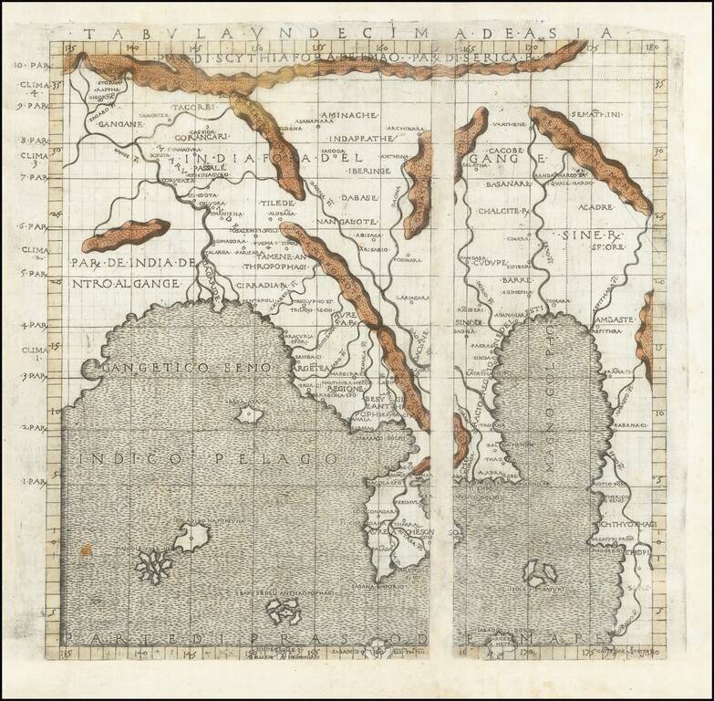
The First Printed Map Based Upon the Projections of the Ancient Greek Geographer, Marinus of Tyre Nice example of Francesco Berlingheri's map Cyprus, the Holy Land and Middle East, from his Septe Giornate della Geographia di Francesco Berlinghieri...
![Tabula IX Asiae [Pakistan & India] (Title on Verso)](/map/small/49098.jpg)
Gorgeous Ptolemaic map of Pakistan and Western India, from Lorenz Fries' edition of Ptolemy's Geographia. This map is largely based on the 1513 map by Waldseemuller.
![Tabula Asiae IX [Northern India & Pakistan]](/map/small/48947.jpg)
Important early map of part of Northen India, Pakistan and the Indian Ocean, based upon the work of Ptolemy. The map is unchanged from the 1540 edition. Munster's Geographia was a cartographic landmark, including not only Ptolemaic maps, but also a...
![Tabula Asiae X [India]](/map/small/0125gh.jpg)
Early example of Munster's map of part of India and the Indian Ocean, extending north to the sources of the Indus and Ganges Rivers, based upon Ptolemy. Munster's Geographia was a cartographic landmark, including not only Ptolemaic maps, but also a...
![[Pakistan, Northwestern India] Tabula Asiae IX](/map/small/46402.jpg)
Fine unfolded example of Gastaldi's map of Northern India and Pakistan. Giacomo Gastaldi is considered as the foremost Italian cartographer of the 16th century along with Paolo Forlani. From Piedmont, Gastaldi established his reputation in Venice and...
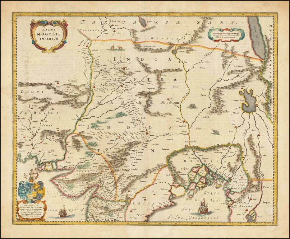
Old color example of Blaeu's map of India, based upon William Baffin's map of India, first published in about 1619. The map is bounded by Pakistan, Afghanistan and Bangladesh and extends inland up the Ganges and Indus Rivers to Tartary and the...
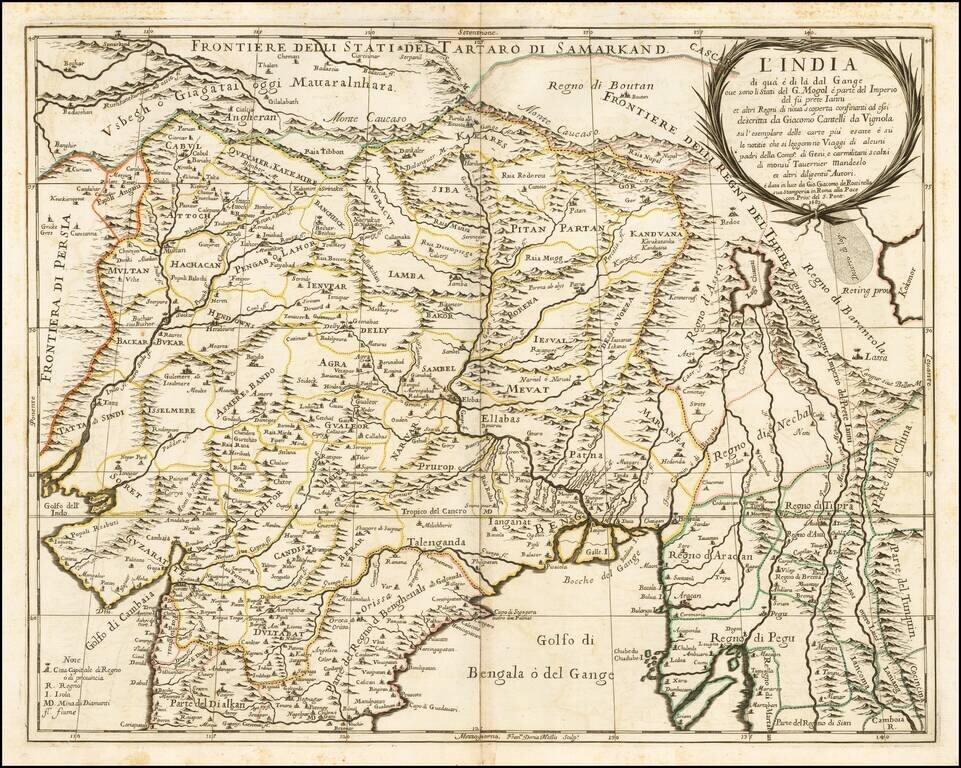
Nice example of the Cantelli-Rossi map of Northern India, Pakistan, Afghanistan and Tibet. The title carries a dedication to Jean-Baptiste Tavernier. Along the northern frontier, the map extends to Cabul, Samarkand, Nupal, Boutan and Lassa. The...
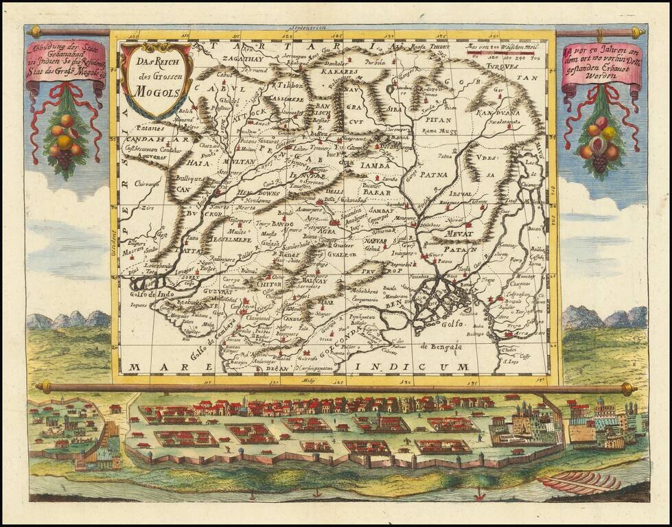
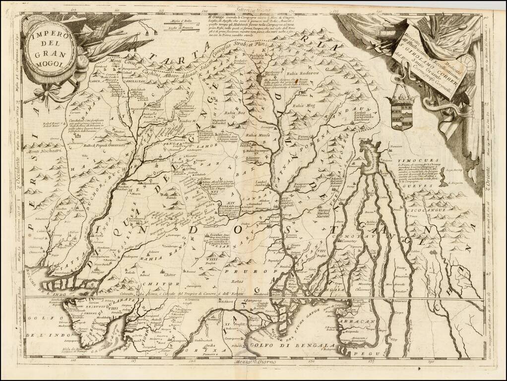
An impressive map of northern India and the surrounding region. The map is superimposed on a scene showing a small city, with a river through the foreground and mountains in the background. Text hangs from the map containing a brief description of the...
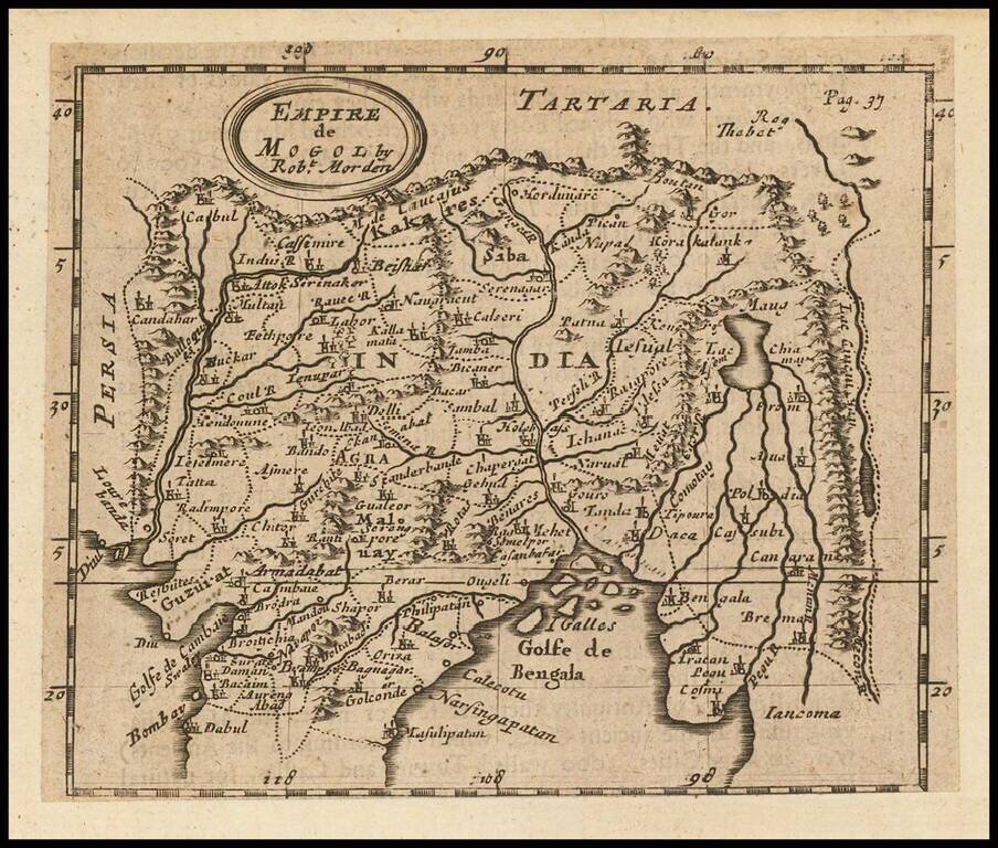
Rare English map, extending from the Gulf of Bengal to the Mecon River. Includes Cabul and Napal in the North and Bombay in the Southwest. One of the earliest obtainable English maps of the region.
Striking example of Coronelli's map of Northern India, Bangladesh, Pakistan, Nepal, etc., and extending north to the Himalayas. Some of the more interesting early place names include Cabulistan, Kandauna, Harduari, Binsola, Burchar, Kachemire, Iamba,...
![[Persian Gulf, India, Pakistan, Iran]](/map/small/41337.jpg)
Striking example of a Coronelli Globe Gore Section, extending from the Persian Gulf to the Maldives and the west coast of India. The map appeared in Coronelli's Isolario.
![[Pakistan Afghanistan & Western India] Tab: IX Asia Continens Ariam, Paropanisum, Drangianam, Arachosiam, et Gedrosiam. . . .](/map/small/54110.jpg)
A striking Ptolemaic map of Central Asia, centered on the Indus River. The map extends from the Gujarat region in the east to west of Karchi, the north to the mountains. Mercator originally published this map in his 1578 edition of Ptolemy's...
![Genealogie Des Empereurs Mogols Depuis Tamberlan ou Tamerlan . . . [maps of the Empire of the Grand Mogol, Kingdom of Kachemire and 3 indigenous views]](/map/small/43161.jpg)
Interesting pair of maps, Genealogical tree and 3 indigenous views of the Mogol Empire, from Chatelain's Atlas Historique. The upper maps show the Empire of the Great Mogol and the Kingdom of Kachimere. The center includes a tree showing the Mogol...