![[Central Idaho & Eastern Oregon Letter Sheet Map] This Is Not A Map Of The World . . . The Weiser Commercial Club, Weiser, Idaho.](/map/small/40601.jpg)
Interesting promotional letter sheet map of the area around Weiser, Idaho, with a letter on the verso referencing the Weiser Irrigation District -- Washington County, Idaho. The map is centered on Weiser, Idaho, and extends southeast to Boise, Idaho,...
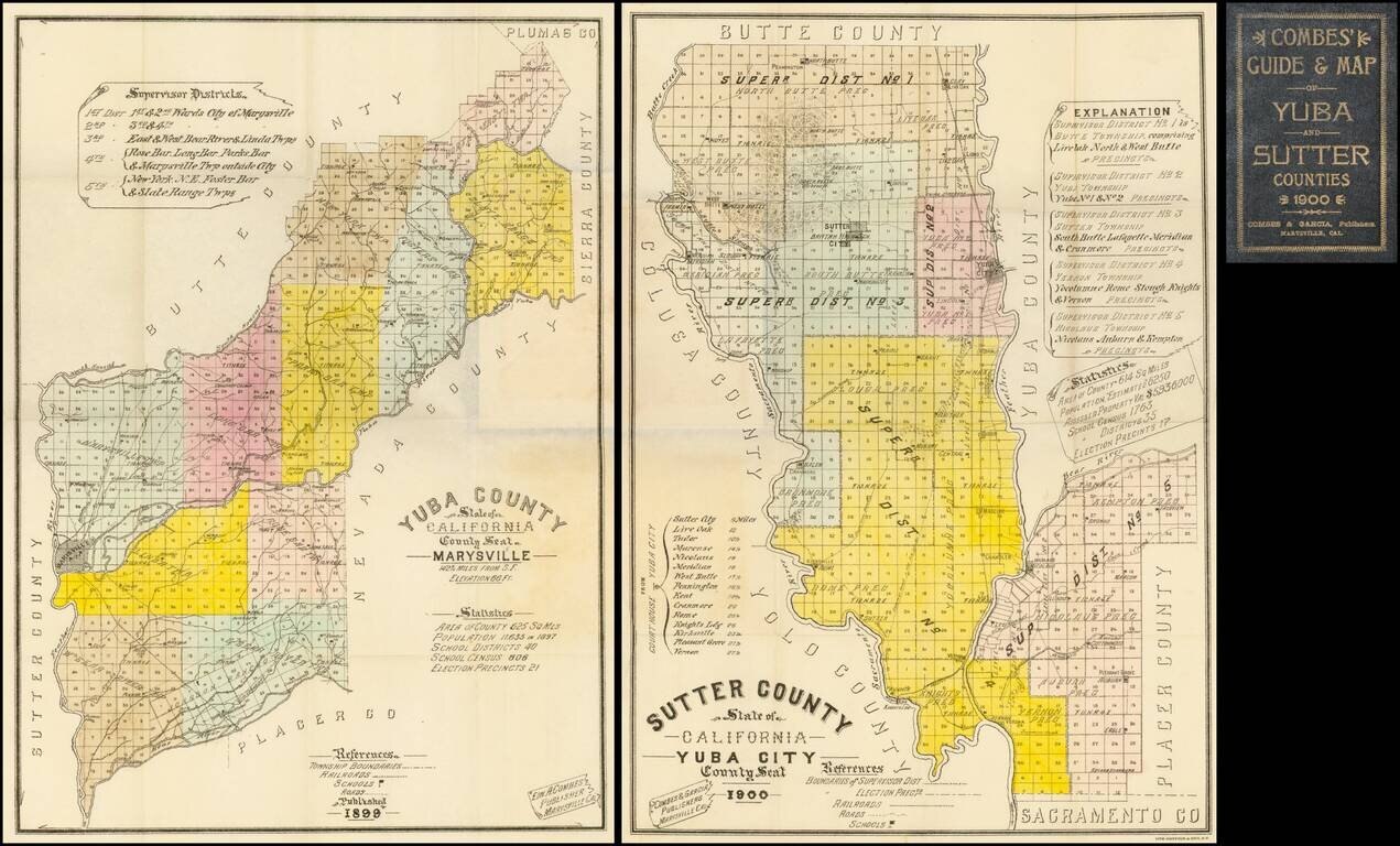
Highly detailed pair of pocket maps of Yuba County and Sutter County, published in Marysville and lithographed and printed by Britton & Rey in San Francisco. The maps are divided into townships and colored by County Supervisor districts, noting...
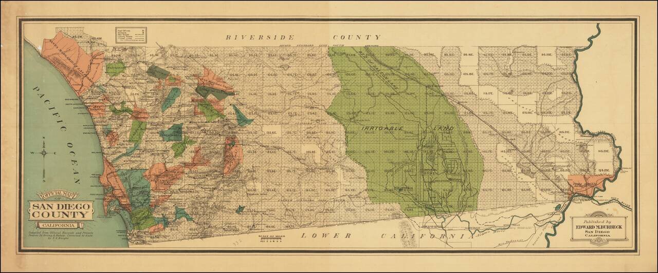
Colored By Ranchos! Fine early map of San Diego County, published by Edward M. Burbeck. the map shows the progress of township subdivisions, but is most noteworthy for its illustration of ranchos in color, an unusual feature for printed maps. Dozens...
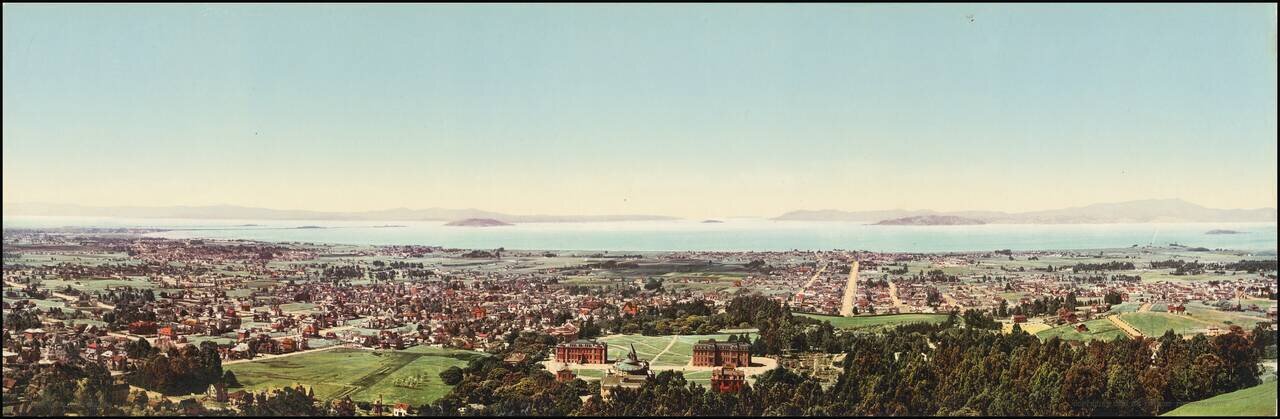
An Early Color Photographic View of UC Berkeley and the Bay Area. Attractive photochrome view of Berkeley, California, taken by one of the West's greatest photographers, William Henry Jackson. In the immediate foreground, the first buildings of the...

Scarce working sea chart of the Strait of Juan de Fuca and contiguous regions, published by the British Admiralty. The map extends from Flores Island and Sydney Inlet in the northwest to Cape Flattery and New Dungeness in the south. with Victoria, and...
![[Map of Alaska Gold Rush Regions -- Chitanika District / 40 Mile District / Birch Creek District / Klondike ] To The Gold Fields of Alaska and Yukon Territory](/map/small/65270.jpg)
Promoting The Newest Alaskan Mining Regions Rare promotional map and brochure, printed for the North American Transportation and Trading Company to Nome and St. Michael. The map provides a large depiction of Alaska and the Klondike Region, with gold...
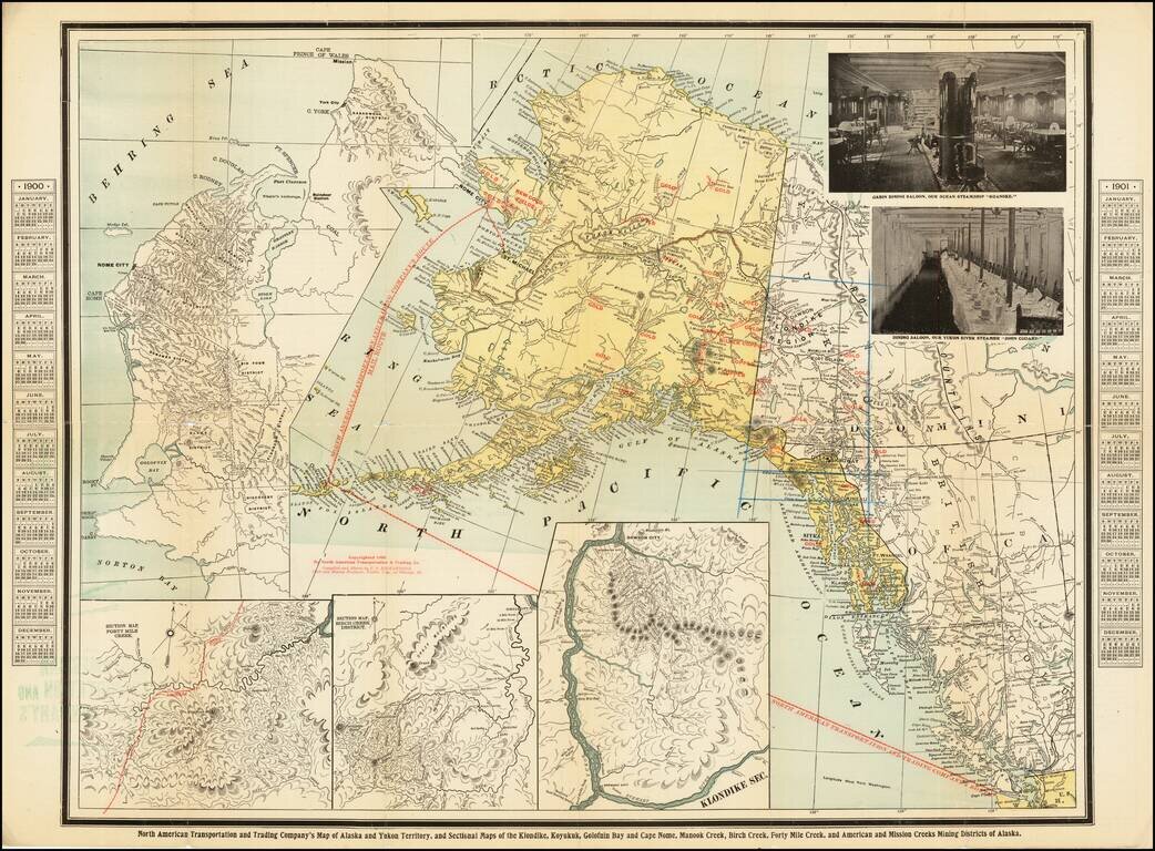
Promoting Nome and Other Alaskan Mining Regions Rare promotional map and brochure, printed for the North American Transportation and Trading Company to Nome and St. Michael. The map provides a large depiction of Alaska and the Klondike Region, with...
![[Mexico City] Reduccion Del Plano Oficial De La Ciudad De Mexico Aumentado y Rectificado Con Todos Ultimos Datos Recogidos De La Direccion De Obras Publicas y de la Oficina Technica del Saneamiento . . . 1900](/map/small/64123.jpg)
Rare separately published map of Mexico City, published by the Compañia Litografica Tipografica S.A. This fascinating and attractive map captures the Mexican Capital when the city had a population of only approximately 500,000. Based on official...
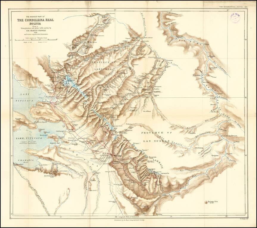
Finely executed map of the area around La Paz and the eastern part of Lake Titicaca, extending north to the Rio Mapiri and Rio Beni regions, published by the Royal Geographical Society. The map illustrates the expedition of William Martin Conway, 1st...
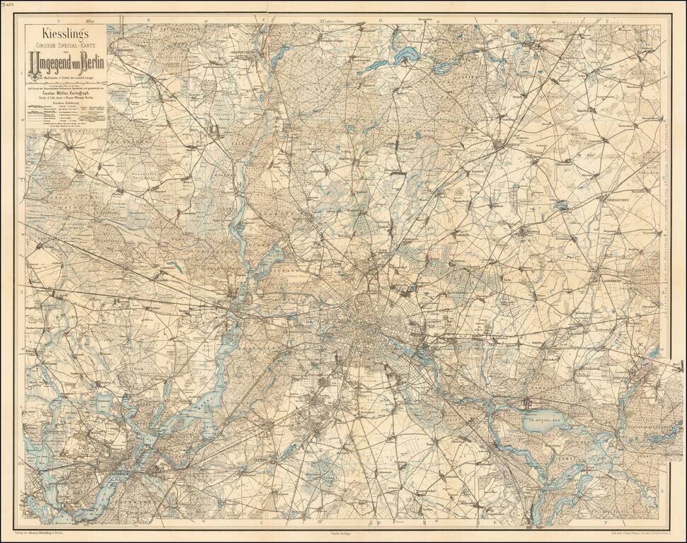
Detailed map of the area around Berlin. The map extends to Potsdam, Cremmen, Oranienburg, Biesenthal, Werneuchen, Rudersdorfer-Forst, Waltersdorf, and Teltow.
Rare separately published map of the Theater of War in China, published by the Chicago Tribune. The image includes Chinese figures in border to left, and an inset map of Peking region to the Gulf of Pechili, and political map of eastern China. The...
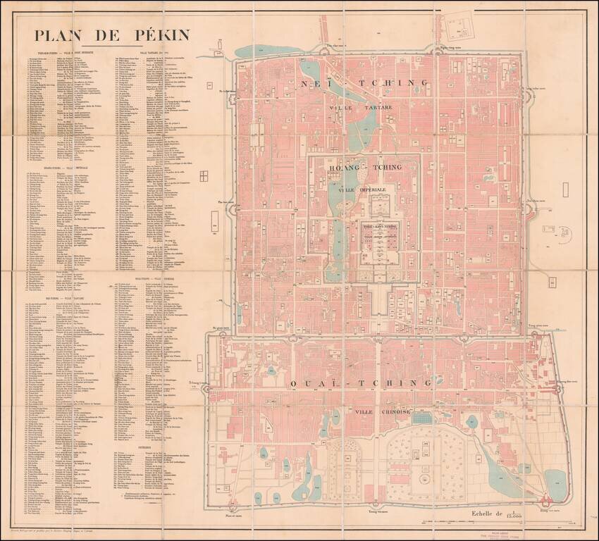
Large French Map of Beijing, Sold by A French Bookseller in Beijing. Lithographed folding map of Beijing published by the French Service Geographique de l'Armee at the beginning of the 20th century. The map includes a massive key with 384 points of...
![[Rare Set of Boxer Rebellion Maps] Boxer-Aufstand in China. Karte der weiteren Umgebungen von Peking und Tientsin von F. von Richthofen . . . [with] Provinz Tschi-Li, Tientstin und Peking mit Umgebung von Dr. O.F. von Mollendorf . . . [and] Nordostli](/map/small/65681.jpg)
Mapping The Boxer Rebellion Rare set of maps illustrating the theater of war during the Boxer Rebellion, issued in Berlin by Dietrich Reimer. Published in the second year of the Boxer Rebellion (1899-1901), the maps would seem to have been published...
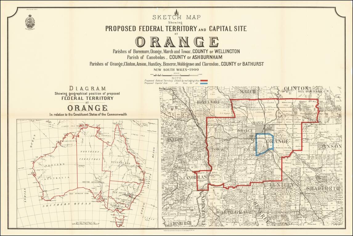
Rare map of a portion of New South Wales, illustrating the proposal to locate the capital of Australia in the City of Orange, New South Wales. At the end of the 19th Century, Sydney and Melbourne were in the midst of a fight regardin the location of...
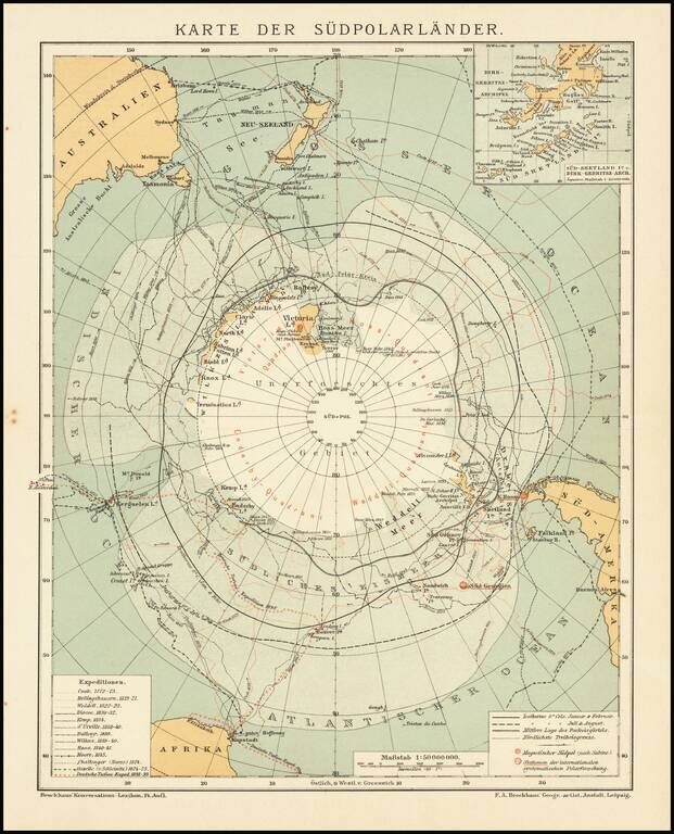
Detailed accounting of the recent explorations in the South Polar Regions. The map identifies the explorations of: Cook 1772-75 Bellingshausen 1819-21 Wedell 1822-23 Biscoe 1830-32 Kemp 1834 d'Urville 1838-40 Balleny 1839 Wilkes 1839-40...
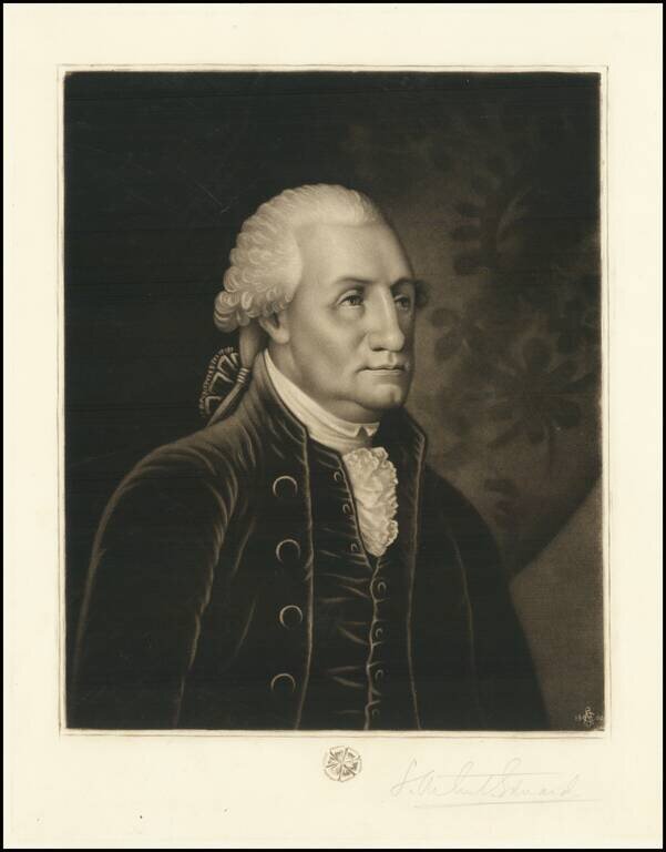
Scarce mezzotint engraving of George Washington created and signed in pencil by S. Arlent Edwards. The portrait shows George Washington, with the monogrammed with "SAE" and the date 1900 in the lower-right corner of the engraving. A rosette lies just...