logo

1900. Karte der Sudpolarlander

  • Karte der Sudpolarlander

Karte der Sudpolarlander information:

Year of creation: 
Resolution size (pixels): 
 5936x7340 px
Disk Size: 
 10.6667MiB
Number of pages: 
 1
Place: 
 Leipzig

Print information. Print size (Width x height in inches):
Printing at 72 dpi 
  82.44 х 101.94
Printing at 150 dpi 
 39.57 х 48.93
Printing at 300 dpi 
 19.79 х 24.47

An example of detailing the file of this map of in a printable high-resolution:

Click to open in high resolution (open in new tab).
Attention! this is just the central piece (central area 960x960 px) of the map file!
This is an example, so that you can see and study the level of detail of a given map. The entire Map will be fully available after payment!

Karte der Sudpolarlander

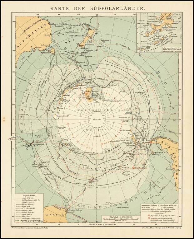
Detailed accounting of the recent explorations in the South Polar Regions.

The map identifies the explorations of:

  • Cook 1772-75
  • Bellingshausen 1819-21
  • Wedell 1822-23
  • Biscoe 1830-32
  • Kemp 1834
  • d'Urville 1838-40
  • Balleny 1839
  • Wilkes 1839-40
  • Ross 1840-43
  • Moore 1845
  • Challenger (Nares) 1874
  • Gazelle (von Schleinitz) 1874-75
  • Deutche Tiefsee-Exped 1898-99

Special conditions for students!

If you are a student, write to us in telegram: @antiquemaps and indicate what material you need and for what work you need a map in high detail. We are ready to provide material on special terms. For students only!

Item information:

Year of creation:
Size:
5936x7340 px
Disk:
10.6667MiB
Number of pages:
1
Place:
Leipzig
Author:
Friedrich Arnold Brockhaus.
$14.99

Related item