logo

1900. Sketch Map Showing Proposed Federal Territory and Capital Site at Orange Parishes of Boreenore, Orange, March, and Towac, County of Wellington; Parish of Canobolas, County of Ashburnham ; Parishes of Orange, Clinton, Anson, Huntley, Beneree, Waldegrave an

  • Sketch Map Showing Proposed Federal Territory and Capital Site at Orange Parishes of Boreenore, Orange, March, and Towac, County of Wellington; Parish of Canobolas, County of Ashburnham ; Parishes of Orange, Clinton, Anson, Huntley, Beneree, Waldegrave an

Sketch Map Showing Proposed Federal Territory and Capital Site at Orange Parishes of Boreenore, Orange, March, and Towac, County of Wellington; Parish of Canobolas, County of Ashburnham ; Parishes of Orange, Clinton, Anson, Huntley, Beneree, Waldegrave an information:

Year of creation: 
Resolution size (pixels): 
 23985x16068 px
Disk Size: 
 72.9861MiB
Number of pages: 
 1
Place: 
 Sydney

Print information. Print size (Width x height in inches):
Printing at 72 dpi 
  333.13 х 223.17
Printing at 150 dpi 
 159.9 х 107.12
Printing at 300 dpi 
 79.95 х 53.56

An example of detailing the file of this map of in a printable high-resolution:

Click to open in high resolution (open in new tab).
Attention! this is just the central piece (central area 960x960 px) of the map file!
This is an example, so that you can see and study the level of detail of a given map. The entire Map will be fully available after payment!

Sketch Map Showing Proposed Federal Territory and Capital Site at Orange Parishes of Boreenore, Orange, March, and Towac, County of Wellington; Parish of Canobolas, County of Ashburnham ; Parishes of Orange, Clinton, Anson, Huntley, Beneree, Waldegrave an

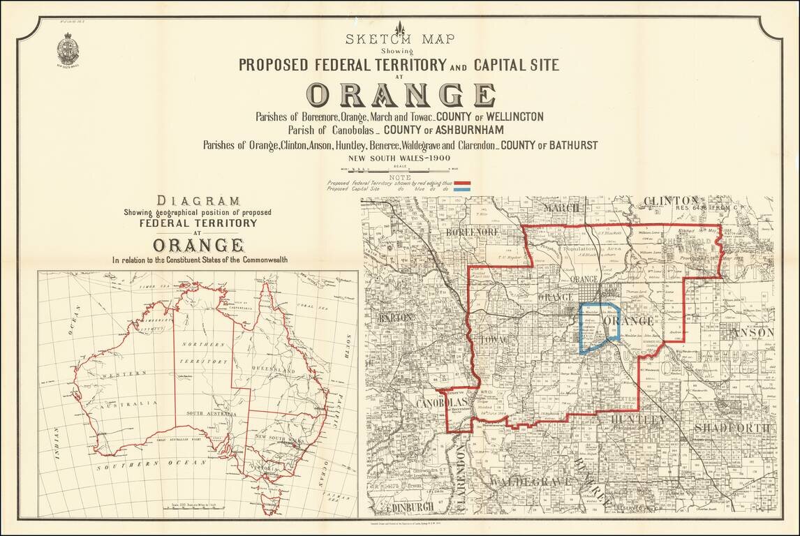
Rare map of a portion of New South Wales, illustrating the proposal to locate the capital of Australia in the City of Orange, New South Wales.

At the end of the 19th Century, Sydney and Melbourne were in the midst of a fight regardin the location of Australia's future national capital.

In 1899, the draft Constitution was amended to include Section 125, which required the creation of a federal seat of government within New South Wales The battle between the federal and New South Wales governments over a suitable site for a capital continued intermittently for more than a decade.

In 1899 the New South Wales Government established a royal commission to investigate possible sites for the federal capital. Many towns in New South Wales were nominated by their residents for the honor and were required to submit details as to climatic conditions, transport accessibility, physical conditions, land ownership and value, plus information on other conditions including food supply, minerals, ability to support a considerable population and conditions for commercial and industrial development. The Commissioner visited many sites and presented his report on October 26, 1900 which favoured the following areas: Orange (or Canobolas), Yass and Bombala-Eden.


Special conditions for students!

If you are a student, write to us in telegram: @antiquemaps and indicate what material you need and for what work you need a map in high detail. We are ready to provide material on special terms. For students only!

Item information:

Year of creation:
Size:
23985x16068 px
Disk:
72.9861MiB
Number of pages:
1
Place:
Sydney
Author:
New South Wales Department of Lands.
$21.99

Related item