
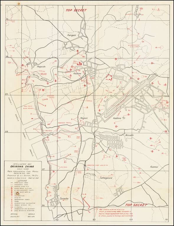
Top Secret American Map Used to Capture Kadena Airfield on Okinawa. Top Secret map of the Okinawa landing beaches Orange 1 & 2, and Purple 1 & 2, and the defenses between those beaches and Kadena airfield. The map was prepared based on...
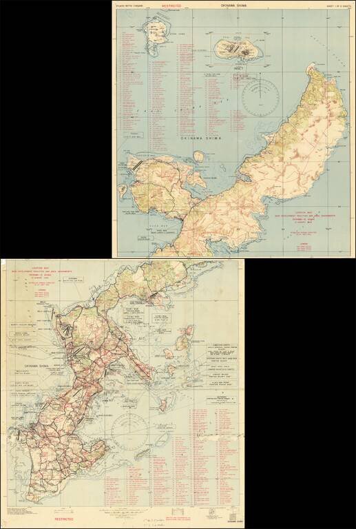
Restricted U.S. Military Map of Okinawa as it was Being Converted into a Major American Base. Color-printed map of Okinawa, produced by the 3020th Engr. Topo. Co. (Corps) on Okinawa, in September 1945, immediately after the end of World War II. The...
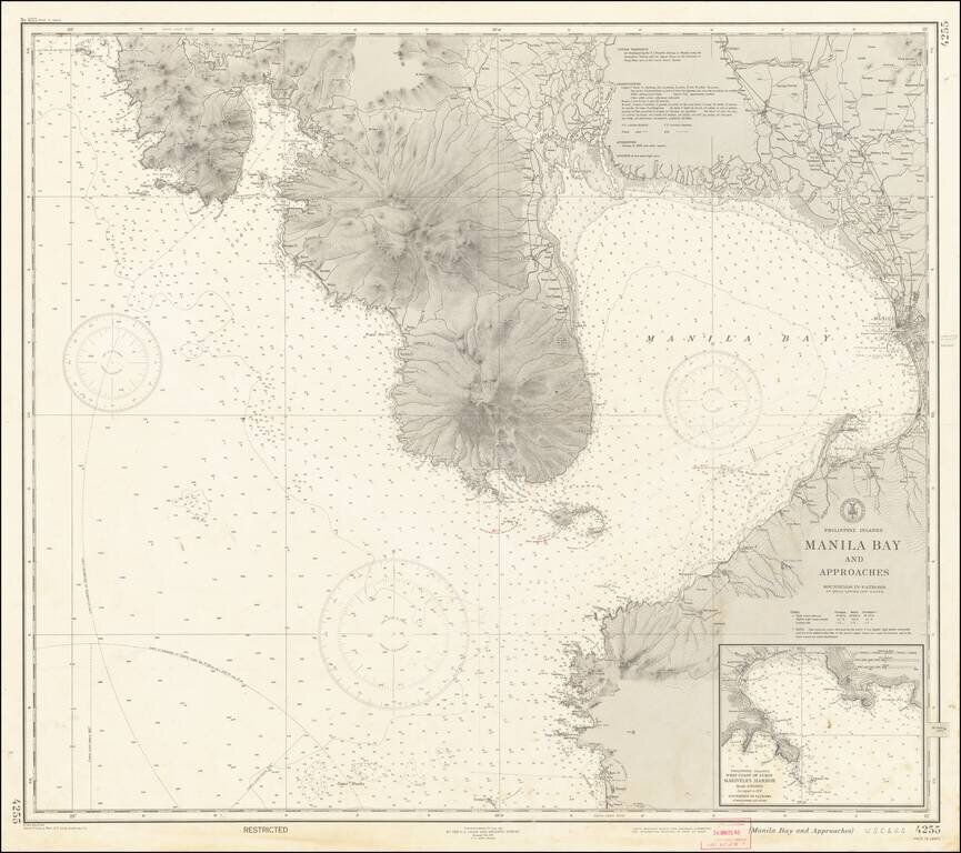
"RESTRICTED" World War II Map of Manila. Detailed chart U.S. Coast and Geodetic Survey (Philippine Divison) of Manila Bay, including Corregidor Island, originally published before the Japanese takeover during the early stages of the Second World War...
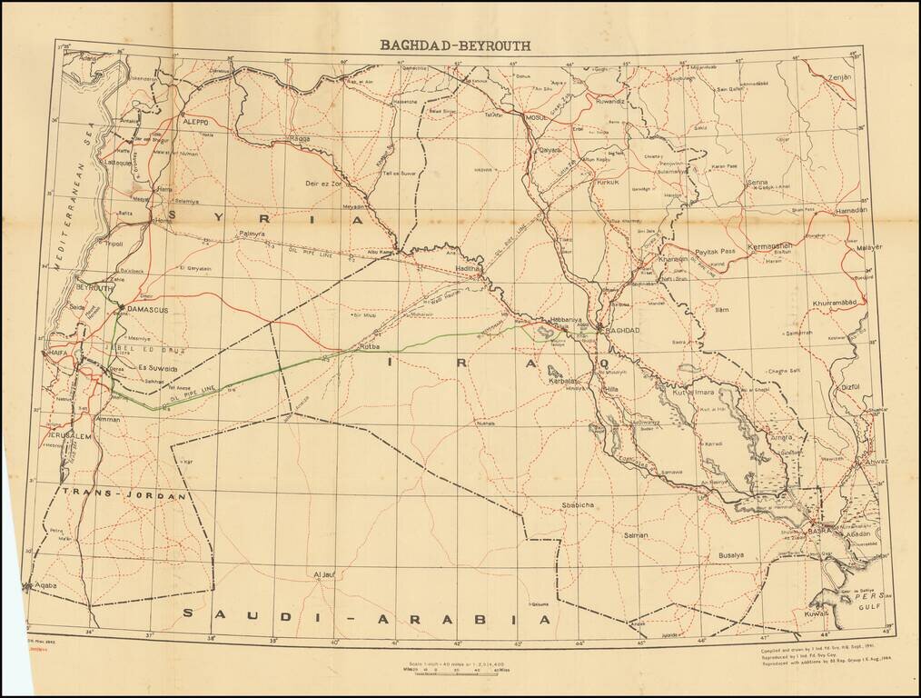
This is a fascinating map and pamphlet created for soldiers travelling in 1944 leave convoys. A major part of this journey included the road from Baghdad to Beirut, a 695-mile route through arid desert. Soldiers would head west from Baghdad until...
![Bandar Abbas [U.A.E. and Strait of Hormuz]](/map/small/67305.jpg)
Detailed Second World War-era map of the Strait of Hormuz and what is now the United Arab Emirates. This is the third edition of the map, published in 1945. This is one of the most detailed maps available from this era. It includes oil wells and oil...
![(Second World War - Normandy Campaign) Cherbourg - Rennes | Adm. Map A To Accompany Administrative Instructions No 1 Hq. Normandy Base Section Hqs. Com[munication] Z[one], E[uropean] T[heater] [of] O[perations] U[nited] S[tates] A[rmy]](/map/small/61727.jpg)
Rare Normandy Campaign Overprint Map Showing The Development of Allied Control of the Area Early in the August 1944 Breakout From Normandy. United States Army map of the Cotentin Peninsula illustrating the military administration of the area, in the...
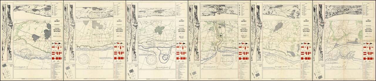
A Complete Set of TOP SECRET Landing Maps For Okinawa Produced in the Lead Up to the Invasion. Six color-printed sheets (of six, i.e., complete), showing all of the American landing beaches on Okinawa. Each sheet is composed of ten frames: the...
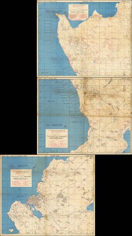
Immediate Pre-Invasion, SECRET Map Set Showing the Landing Beaches and Defenses on Okinawa. Fantastic set of three color-printed maps (the complete set) "prepared at the request of 10th ARMY" showing the west coast of Okinawa and the extent of the...
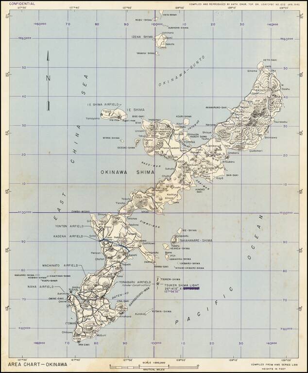
This is a military chart showing Okinawa in detail, with a particular focus on the military installations of the island. The map depicts the island in full, along with some nearby islands including Ie Shima and Iheya Shima, some of which would also see...
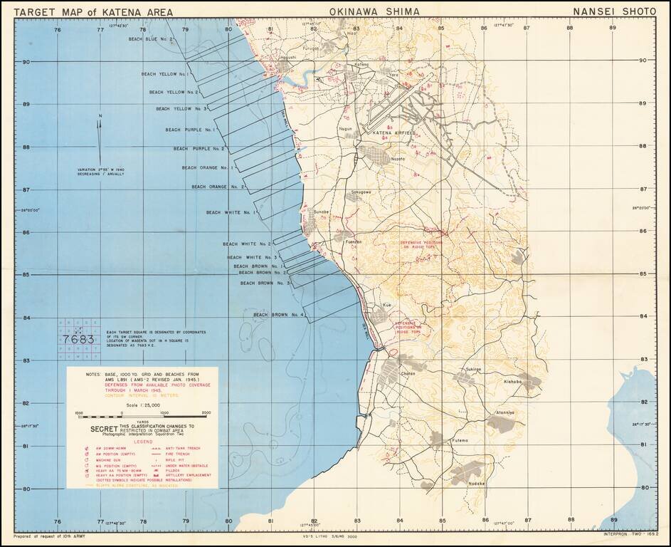
Immediate Pre-Invasion, SECRET Map Showing the Landing Beaches (Blue No. 2 through Brown No. 4) and Defenses on Okinawa. Fantastic color-printed map "prepared at the request of 10th ARMY" showing the west coast of Okinawa and the extent of the U.S....
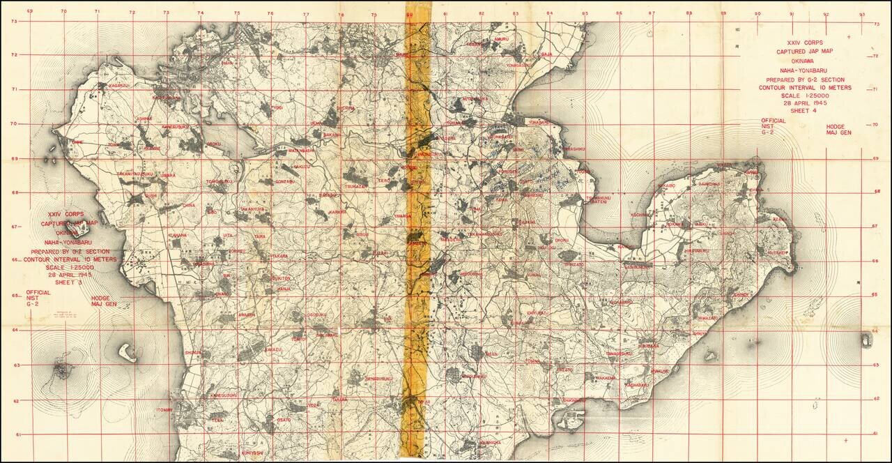
"Captured Jap Map" With Manuscript Additions by an American G.I. Important U.S. military map prepared during the invasion of Okinawa from captured Japanese maps, for use by XXIV Corps. An interesting product of wartime necessity, this map was...
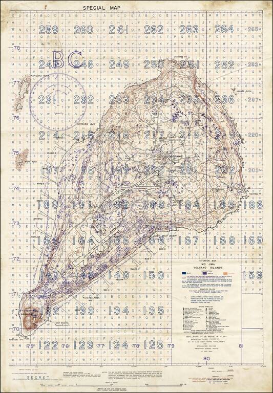
"SECRET" Situation Map of Iwo Jima Detailing the Minutiae of the Japanese Defense of the Island. A rare "Secret" situation map of Iwo Jima prepared in anticipation of the 19 February 1945 U.S. invasion of the island. The map shows the landing zones on...
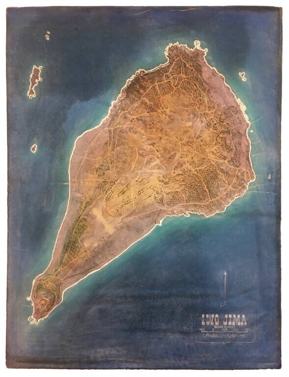
Exceptionally Rare U.S. Military Terrain Model of Iwo Jima, Made in 1945. Foam and rubber terrain model map of Iwo Jima, probably made by the U.S. Navy Reserve group "Building 14", Hawaii, which was in charge of military model making in the Pacific....
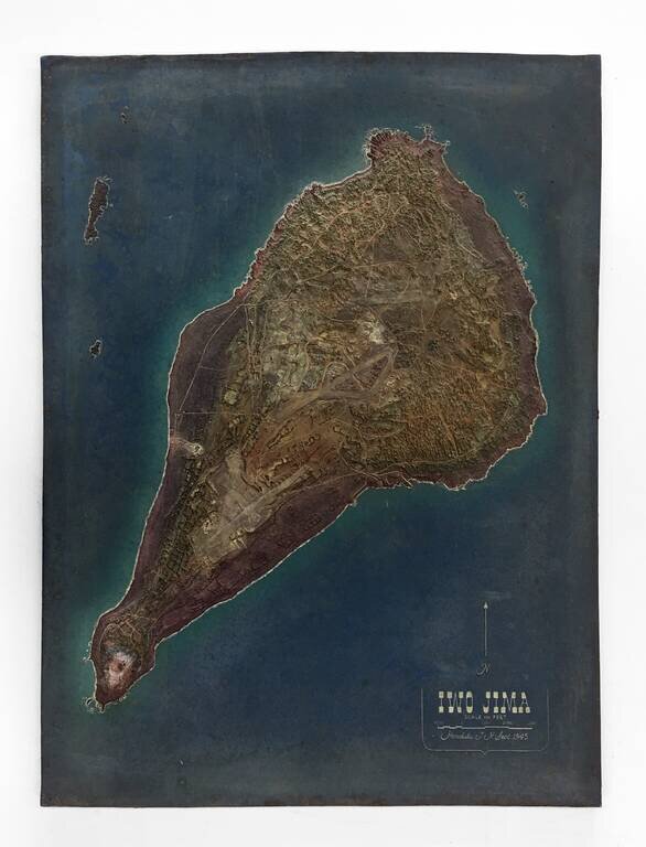
Exceptionally Rare U.S. Military Terrain Model of Iwo Jima, Made in 1945. Foam and rubber terrain model map of Iwo Jima, probably made by the U.S. Navy Reserve group "Building 14", Hawaii, which was in charge of military model making in the Pacific....
![(Second World War - Iwo Jima) Beach Diagram Southwestern Beaches, Iwo Jima Information Taken from Aerial Photographs of 4 July 1944... [with] Becah Diagram Southeastern Beaches, Iwo Jima Beach Information taken from Aerial Photographs of 4 July 1944...](/map/small/62967.jpg)
"SECRET" Beach Diagrams used for Planning and Executing the American Landings on Iwo Jima. Two very rare color-printed views of the southern beaches of Iwo Jima, the southwestern section of which served as a potential landing area for the U.S. Marine...
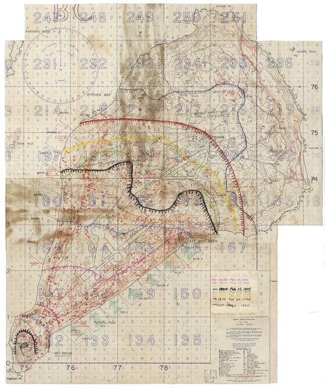
Secret Enemy Installation Map of Iwo Jima prepared for the American invasion, heavily annotated to show the progress of the battle. A rare “Secret” map of Iwo Jima, issued little more than a week before February 19, 1945 U.S. invasion. The map...