
![(Second World War - Eastern Front) [Strikes by the Red Army on the Enemy in 1944] Удары Красной Армии По Противнику в 1944г.](/map/small/68414.jpg)
Extremely rare Red Army-published map of the progress of the Second World War on the Eastern Front during 1944. The map shows the extensive gains of the U.S.S.R. throughout late 1943 and 1944, from their nadir, with the Germans at the outskirts of...
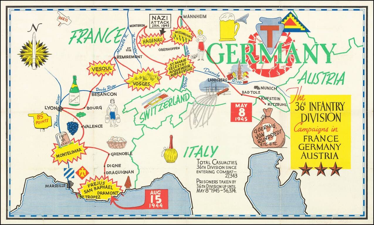
Triumphal Pictorial Map of the 36th Infantry Division's Campaign in Europe. The map shows the T-patchers landing in Saint-Raphaël-Fréjus in southern France on Aug. 15, 1944, during Operation Dragoon. The Division proceeds to Montelimar where it...
![Gibraltar to Berlin. [World War II Broadside Map.]](/map/small/63270.jpg)
Fascinating WWII broadside propaganda map, published in India, in order to keep the local populous informed about the War. The map shows the theater of war in parts of Western Europe and North Africa, with the course of railways, roads, and tracks....
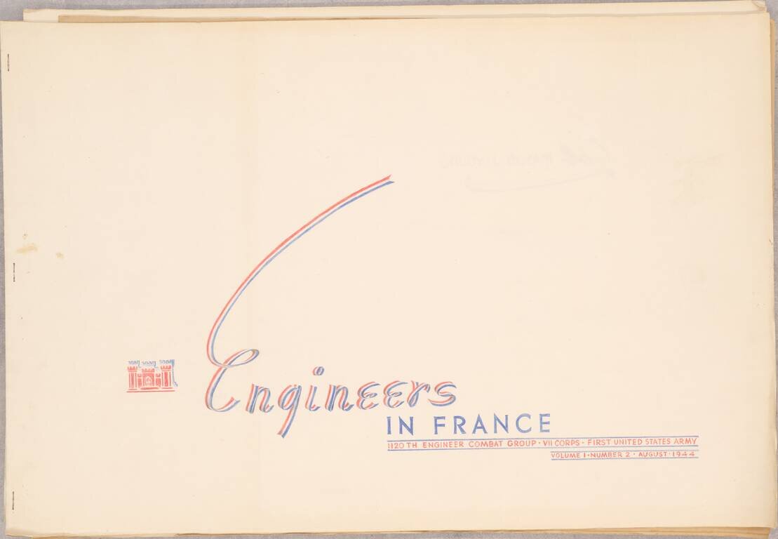
A Series of Albums Commemorating American Engineer's Roles in the Liberation of Europe, Made for a Decorated Colonel This is a truly outstanding work consisting of three booklets, each showcasing the role of the 1120th Engineer Combat Group, attached...
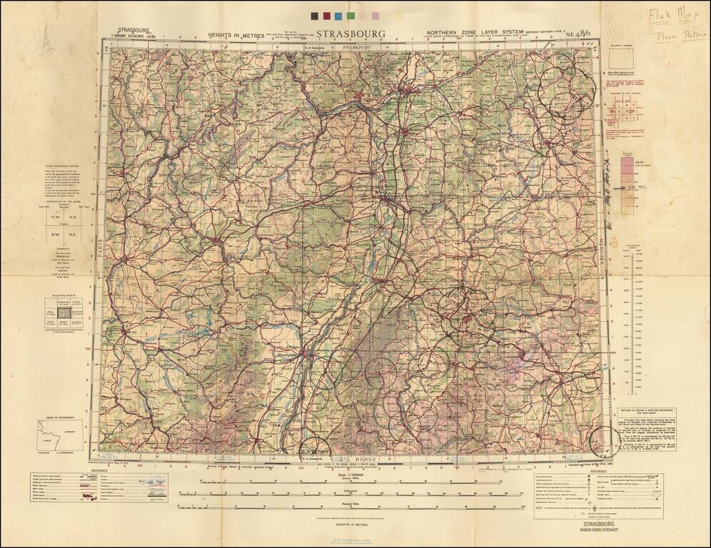
A Wall of Flak Batteries Leading into Germany. Detailed WWII air navigation map of the area around Strasbourg, published by the British War Office. The map is noteworthy for the manuscript circles highlighting the flak batteries stationed in major...
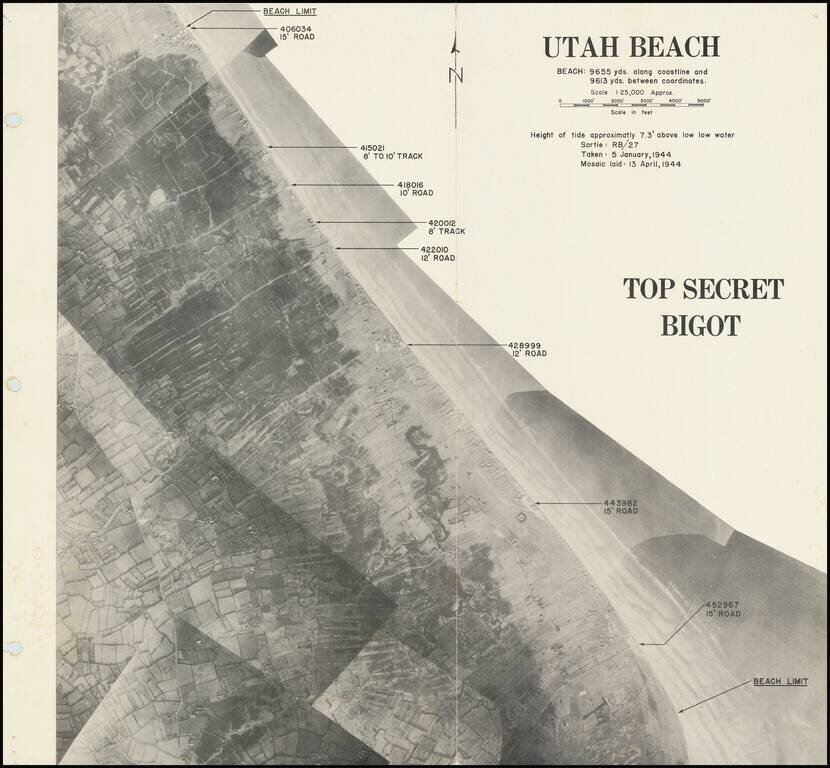
Rare “BIGOT”-rated photomosaic planning map for the D-Day landing at Utah Beach. A rare composite photographic map prepared for the D-Day landing at Utah Beach. From the Neptune Monograph, the definitive briefing book issued to senior American...
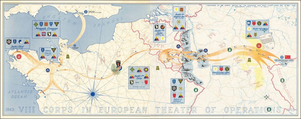
Superb map of the actions of VIII Corps, US Army, from 1943 to 1945. The map was prepared by VIII Corps Office of the Engineer and 665th Engr. Topo. Co. on the 9th of May 1945. The map, which stretches from Normandy to Czechoslovakia, lists the...
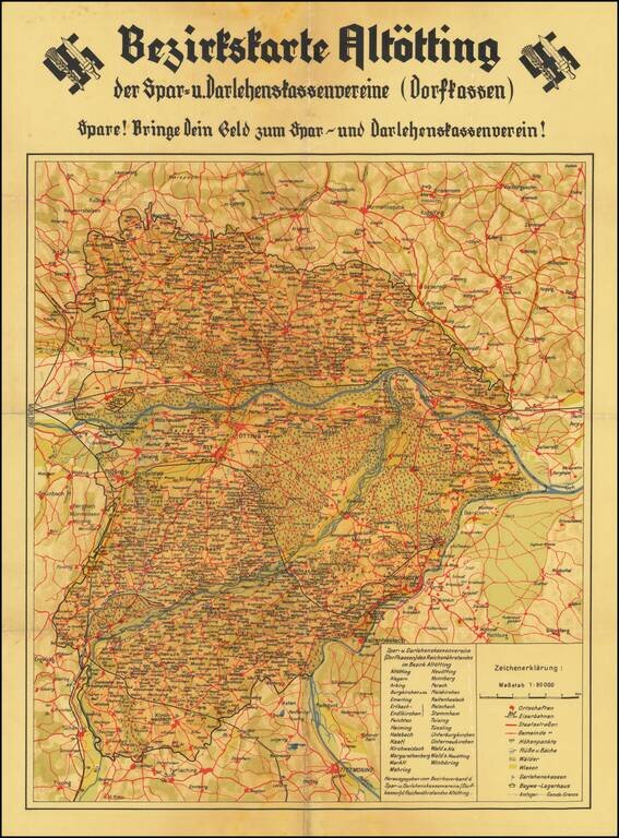
"Blood and Soil" Rare Nazi-era map of the area around Altötting in Bavaria, promoting the deposit of money in Savings and Loan Associations and Credit Unions. This map is part of the ideological propoganda war of "Blood and Soil" waged on the...
![(Second World War - Nazi Germany) L'Allemagne Paradis du Tourisme. [Germany The Paradise of Tourism.]](/map/small/63210.jpg)
Striking propaganda and travel map of Germany, published by the Reichsbahnzentrale fur den Deutschen Reiseverkehr and the German Railways Information Bureau. Text, map, and graphics on the verso. Includes decorative border alternating crests and "La...
![[Uniforms and Insignia of the German Army] Форма Обмундирования и Знаки Различия Германской Армии](/map/small/67803.jpg)
A very rare pre-World War II Soviet poster of Nazi-era German military uniforms. Underneath the title is an elaboration of colors used on the strap edging and buttonholes of troop uniforms, depending on their area of service. From left to right:...
![[Fascist Organizations of Germany] Фашистские Организации Германии](/map/small/67801.jpg)
One of the Most Dramatic Soviet Cartographic Appraisals of Nazi Germany. A fascinating Soviet poster map documenting the "Fascist Organizations of Germany", recording their structures, uniforms, and locations within the country, prior to the Second...
![[Second World War - Battle of Berlin] Großer Silva-Stadtplan von Berlin](/map/small/63107.jpg)
Hand-Annotated Map of the Battle of Berlin, Showing the Progress of the 89th Armenian Rifles through the City, to the Reichstag. From the Personal Papers of the Major General Who Led the 89th Rifles' Assault on Berlin. An excellent Battle of Berlin...
![(Second World War - Allied Bombing of Germany) Offensive Aerienne des Allies contre l'Allemagne Jusqu'au 1 Fevrier 1941 [Allied Air Offensive against Germany Up To January 1st 1941]](/map/small/67411.jpg)
Broadside showing the location of bombing runs of the Allied bombers in Germany up to January 1, 1941. Inset map shows the heavy concentration of bombs in the Ruhr Valley, with a key locating the different types of facilities being bombed:...
![(Second World War - First Soviet Breakthrough into Germany) Генеральный Штаб Красной Армии - (Фюрстенвальде) | (Франкфурт) [General Staff of the Red Army - (Fürstenwalde) | (Frankfurt)]](/map/small/63108.jpg)
Manuscript-Annotated Map Showing Soviet Forces Entering Germany for the First Time! A fantastic map showing the first Soviet breakthrough into Germany-proper, during the leadup to the Battle of Berlin and the closing stages of the Vistula-Oder...
![(Second World War - Battle of Berlin) Генеральный Штаб Красной Армии Берлин-7 [General Staff of the Red Army Berlin-7]](/map/small/64471.jpg)
Detailed Soviet 1:100,000 map of Berlin, used during the Red Army encirclement of the city in the Battle of Berlin. The map covers several hundred square kilometers around Berlin, at the center is the city, labeled in Russian ("Берлин"). To the...
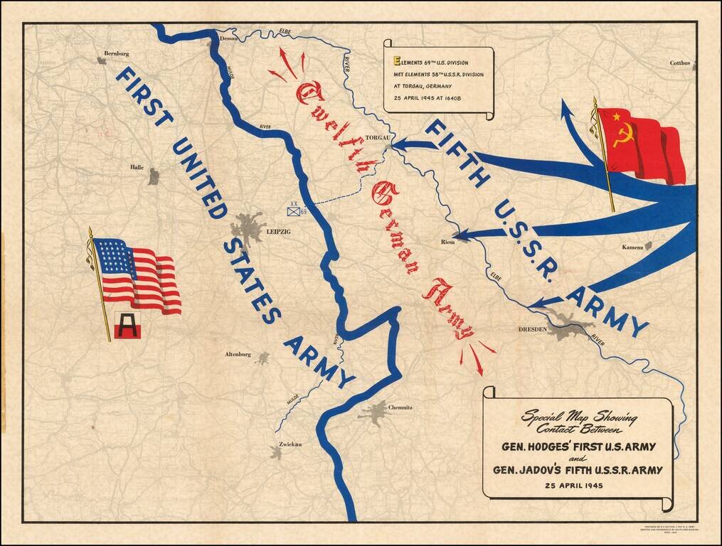
A Map Celebrating Elbe Day -- World War II Fine thematic map showing the progress of the American and Russian Forces against the last remnants of the German Army, published on Elbe Day. The two forces are shown moving toward each other, superimposed...