
Rare old maps of the United States.
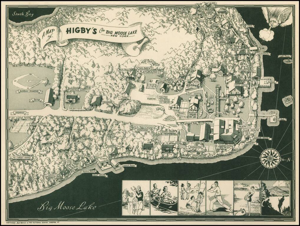
Scarce pictorial map of Big Moose Lake. As noted by Rumsey: Pictorial map of Higsby Campground on Big Moose Lake, New York. Shows roads, trails, beaches, buildings, Campgrounds, Sports and Recreation Facilities. Buildings are named. On bottom...
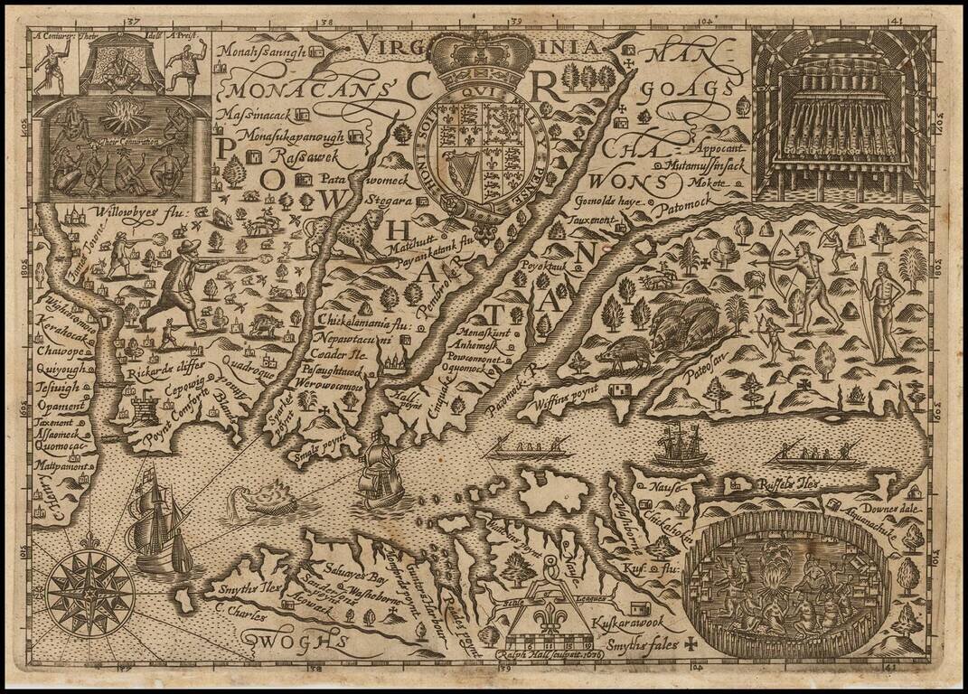
Early English Colonial Map of Virginia Rare map of Virginia, engraved by Ralph Hall, for Wye Saltonstall's Historia Mundi. This remarkable map of Virginia is based in part upon John Smith's map of Virginia, embellished with a lively and unique...

The First Dutch Map of Virginia Fine, wide-margined, old color example of Blaeu's map of Virginia, and the Chesapeake region, based upon John Smith's map of Virginia, the most important map of Virginia published in the 17th Century. This is the...

A highly decorative and important sea chart showing Florida, the Gulf Coast, Caribbean, Central America and the region from south of the mouth of the Delaware River. This fine separately published map was first engraved around 1650, but is based...
![A New Map of Virginia [and the Chesapeake]](/map/small/48950.jpg)
First State of Morden's Map of Virginia. Fine example of Robert Morden's map of Virginia, one of the earliest obtainable English maps of the Chesapeake region. Beginning in the 1670s, the English fortunes in North America took a dramatic turn...
Early map of the region from New York City to Cape Henry, centered on the Cheaspeake and Delaware, from Abraham Wolfgang's L'Amerique Angloise, ou Description des Isles et Terres dur Roi Angleterre, dans L'Amerique, published in Amsterdam in 1688. The...

Christopher Browne's Map of the Chesapeake & Delaware Bay Regions -- The First Map to Accurately Depict The Boundary Line Which Settled The Penn-Calvert Boundary Dispute, Which Would Become The Mason-Dixon Line Rare second state of Christopher...
![Carte Particuliere de Virginie, Maryland, Pennsilvanie, La Nouvelle Jarsey. Orient et Occidentale [Heighten in Gold!]](/map/small/61392mp2.jpg)
Heightened with Gold Leaf -- Fine Old Color Fine early large-format chart of Chesapeake Bay and the Delaware Estuary, by Pierre Mortier. This detailed and attractive chart focuses on Chesapeake Bay, and includes all of the Tidewater areas of...
Antique Sea Chart of the Chesapeake Region Published By The Leading Chartmaker of the Dutch East India Company Attractive and highly detailed map of the Chesapeake region, extending south to Cape Henry and north to southern New Jersey and the...
![d'Engelze Volkplanting in Virginie door Iohan Smith Bezogt en verder uytgeset [John Smith Map of Virginia, Maryland, Pennsylvania, New Jersey, etc.]](/map/small/61141.jpg)
Scarce map of the region from the Chesapeake to Long Island, intended to illustrate the Dutch Translation of Smith's Account of Virginia. The map is loosely based upon John Smith's map, extending from the Chesapeake to Long Island, and including a...

John Senex's edition of the Augustine Hermann Map of the Chesapeake. An antique map of the Chesapeake Bay from John Senex's edition of Christopher Browne's seminal map. Includes the Delaware Bay, Maryland and parts of Pennsylvania and New Jersey,...
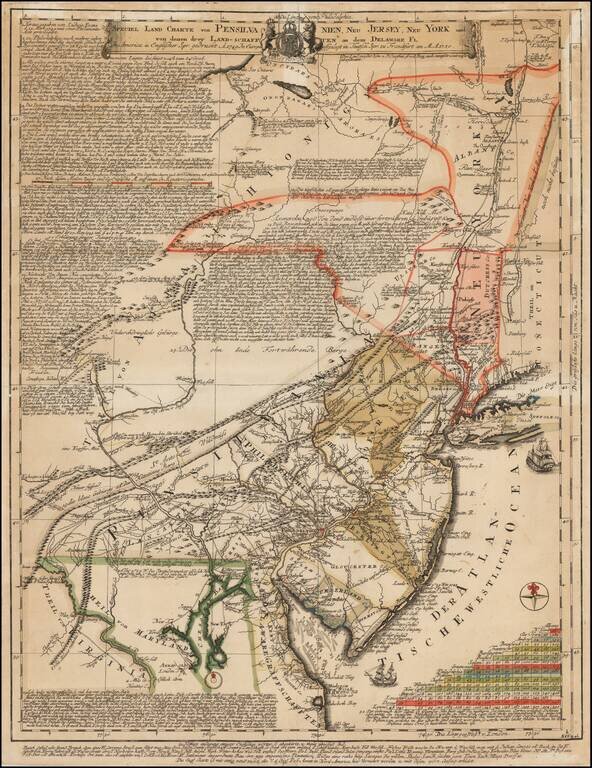
Extremely Rare German Edition of Lewis Evans' Landmark 1749 Map Fine example of the German edition of Lewis Evans' important map, A map of Pensilvania, New-Jersey, New-York, and the three Delaware Counties, published on March 25, 1749 in...
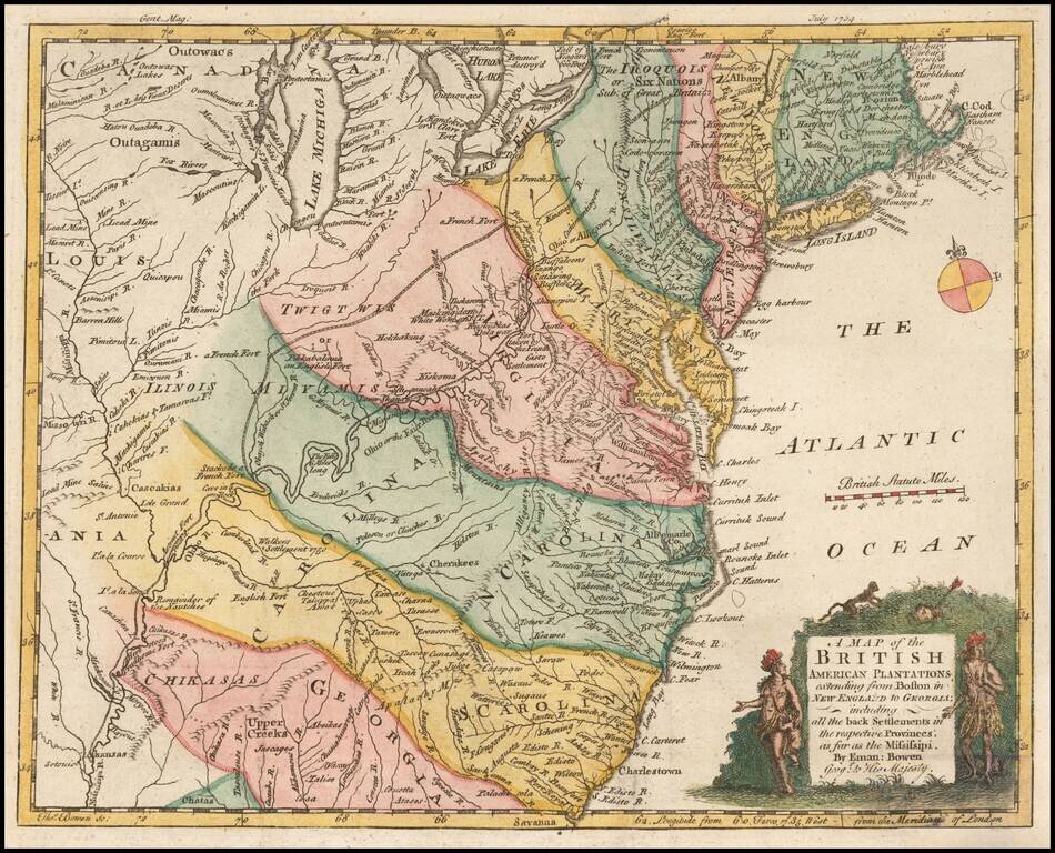
Nice example of this early map of the British Colonies, issued one year prior to the seminal map of John Mitchell. The map is based largely upon the work of D'Anville. The map is quite remarkable for the time period, showing several early Western...

Detailed map of Maryland, Delaware, the Chesapeake Bay and parts of New Jersey and Pennsylvania. Engraved by Thomas Kitchin. The map shows towns, counties, roads, rivers, bays, and a host of other details. The map accompanied the August 1757 edition...

The Survey of the Mason Dixon Line. Detailed regional map of the Chesapeake and contiguous parts of Maryland, Virginia, Delaware, New Jersey and Pennsylvania, showing the results of Mason & Dixon's survey of the boundaries between Pennsylvania...

A nice example of the 1775 edition of Fry & Jefferson's map of Virginia and Maryland, widely regarded as the most important and influential 18th century map of Virginia and Maryland. Originally prepared by Joshua Fry of William & Mary and...