
Map size in jpg-format: 149.975MiB
Click to open in high resolution (open in new tab).
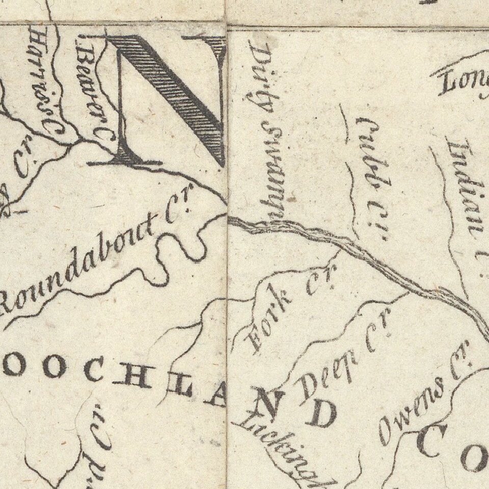
A nice example of the 1775 edition of Fry & Jefferson's map of Virginia and Maryland, widely regarded as the most important and influential 18th century map of Virginia and Maryland.
Originally prepared by Joshua Fry of William & Mary and Peter Jefferson (father of President Thomas Jefferson) at the request of Lord Halifax in 1751, the Fry-Jefferson was a monumental leap forward in the mapping of the region. It is the first map to accurately depict the Blue Ridge Mountains and the first to lay down the colonial road system of Virginia. A great number of plantations are located and include the family names of the Virginia plantation owners of the period. The cartouche, showing a tobacco warehouse and wharf, is one of the earliest printed images of the Virginia tobacco trade.
One of the first actions of Lord Halifax upon becoming president of the Board of Trade and Plantations in 1748 was to request information concerning activities in the Frontiers and of potential French encroachments on the British territorial claims. In 1750, the Board required that each colony to conduct a comprehensive survey. The acting Governor of Virginia, Col. Lewis Burwell commissioned Fry & Jefferson to prepare a map of the Virginia colony.
Joshua Fry, a mathematician at the College of William and Mary, and Peter Jefferson, a surveyor (father of Thomas Jefferson), had together previously drawn the boundaries of Lord Fairfax's lands in 1746 and surveyed the Virginia-North Carolina boundary in 1749. First issued in 1751, the map incorporates the original surveys of Fry & Jefferson with existing data. A major revision in 1755 incorporated important information about the western part of the colony from the journals of John Dalrymple and Christopher Gist, the latter of whom is credited in the upper left part of the map with having contributed to the revisions. It is the 1755 edition that forms the basis for the subsequent editions.
The map is known in 8 editions. The first four states are so rare as to be virtually unobtainable. The present example is state 6, which includes the updated 1775 date but is otherwise identical to the 1768 edition, the first obtainable state.
If you are a student, write to us in telegram: @antiquemaps and indicate what material you need and for what work you need a map in high detail. We are ready to provide material on special terms. For students only!
![[Wall Map] West-Indische Paskaert waer in de graden der breedde over weder zyden vande middelyn wassende so vergrooten dat die geproportioneert syn tegen hunne nevenstaende graden de lengde.](/map/small/60169.jpg)

![[The First Maps in a la poupée Printed Color] Cartes en Couleur des Lieux Sujets aux tremblements de Terre Dans toutes les parties du Monde Selon le Sisteme de l’impulsion Solaire](/map/small/52293op.jpg)