
![[France] Tertia Europa Tabula](/map/small/65594.jpg)
The First Map of France Printed North of the Alps Based upon the work of the 2nd Century Alexandrian polymath Claudius Ptolemy, this map is perhaps the single most important and decorative map of the region printed in the 15th Century. The map...
![[Tabula Moderna Francie]](/map/small/64753.jpg)
The First Modern Map of France. Very scarce etched and engraved map of France, published in the 1507 edition of the Rome Ptolemy Atlas. The map is a marked improvement from the Ptolemy-based map of the earlier editions, adding islands, topography,...
![[France] Europae Tabula III](/map/small/60010.jpg)
Fine example of Gastaldi's map of France, based upon Ptolemy. Giacomo Gastaldi is considered as the foremost Italian cartographer of the 16th century along with Paolo Forlani. From Piedmont, Gastaldi established his reputation in Venice and was...
![[Modern France] Gallia Nova Tabula](/map/small/60252.jpg)
Nice example of Gastaldi's modern map of France, one of the earliest reasonably obtainable maps of modern France available to collectors. Giacomo Gastaldi is considered as the foremost Italian cartographer of the 16th century along with Paolo Forlani....
![[Boulogne-sur-Mer] Bologna in Francia](/map/small/61425.jpg)
The French Reconquest of Boulogne-sur-Mer from Henry VIII of England Important early view of the Siege of Boulogne, illustrating the French Troops under Henry Ii of France laying siege to the English controlled city. The secondary title, in Italian,...
![[Plan of the Siege of Guînes, France] Ritratto Della Fortezza di Ghines, presa perforza dallo essecito del Re Christianissimo . . .](/map/small/41817sb.jpg)
State 3 of rare plan of the Siege of Guînes, France, by Pietro de Nobili. Rare third state of this finely engraved battle plan depicts the Siege of Guînes (near Calais, France), in January 1558, following which a French army seized the fortress...
![[Calais] Chales](/map/small/61280sb.jpg)
Extremely Rare Plan of The Siege of Calais in 1558 Rare early map / view of Calais, showing its capture by the French in 1558. The map is very similar to the map of Bertelli, but no engraver or publisher is given. Siege of Calais The Siege of...
![[Calais] Chales](/map/small/61301sb.jpg)
Extremely Rare Plan of The Siege of Calais in 1558 Rare early map / view of Calais, showing its capture by the French in 1558, which is believed to be by Antonio Lafreri. First state of Lafreri's map of Calais, but without mounted legend and note at...
![[Calais] Il vero ritratto de Cales preso a Inglesi del Re Cristianissimo l'Anno M.D.L V III](/map/small/61403.jpg)
"When I am dead and cut open, they will find Philip and Calais inscribed on my heart" -- The Siege of Calais in 1558 Rare early map / view of Calais, showing its capture by the French in 1558. Fourth and final state of this are map of the Siege of...
![[Siege of Poitiers] Vero disegno della nobilissima Citta di Poitiers, nella Gallia Celtica, Soggi Aquitania detta, e, da Ceare Pictones Populi. Con il tremendo assedio de essa, postolio alli xxvij, di Luglio di questo anno M.D. Lxix da GAsparo Coligni S](/map/small/61361sb.jpg)
Rare separately published broadside illustrated the Siege of Poiters in 1569. Detailed birds-eye view of the city of Poitiers, engraved to celebrate the resistance to the siege by the Huguenots led by Admiral Coligny. The long title tells how the city...
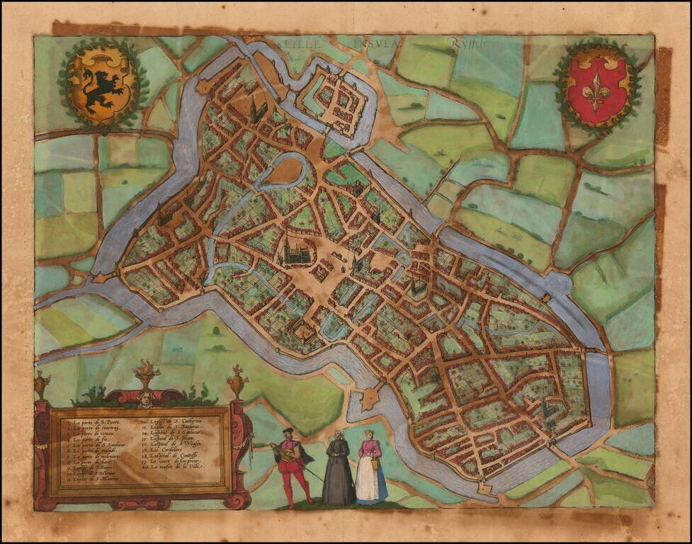
Detailed plan of the city of Lille, in France. This very detailed plan shows accurately the town with its streets, places, churches and squares. Decorated with 2 coats of arms, figures in the foreground and a title cartouche. From Braun &...
![Montes, Hannoniae Metropolis [and] Atrebatum, Episcopalis Et Metropolica Artesiae Citivas](/map/small/41468mp2.jpg)
Two early city views of Bergen / Mons in Hainaut, Belgium and Arras, Nord-Pas-de-Calais, North of France, from an early edition of Braun & Hogenberg's Civitates Orbis Terrarum, the most prolific compilation of city views published in the 16th...
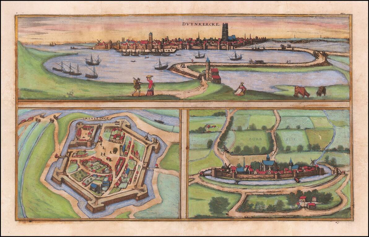
Fine early city views of Dunquerke, Gravelins and Bourbourg, from an early edition of Braun & Hogenberg's Civitates Orbis Terrarum, the most prolific compilation of city views published in the 16th Century.
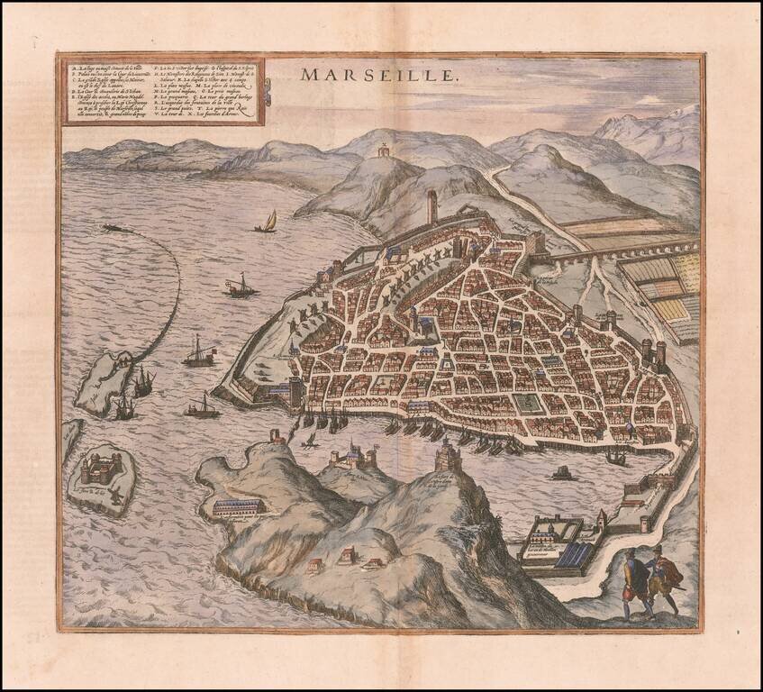
Nice example of this inconic plan of 16th Century Marseille, which appeared in volume 2 of Braun & Hogenberg's 6 volume Civititas Orbis Terrarum.
![[Viscounty of Limoges] (Manuscript map of Southern Limousin]](/map/small/61140.jpg)
An early manuscript map showing the Viscounty of Limoges 16th Century Map of the southern part of Limousin, drawn in an early hand. The map is oriented with south at the top and extends from Limoges on the Vienne River to the towns of Tulle and...
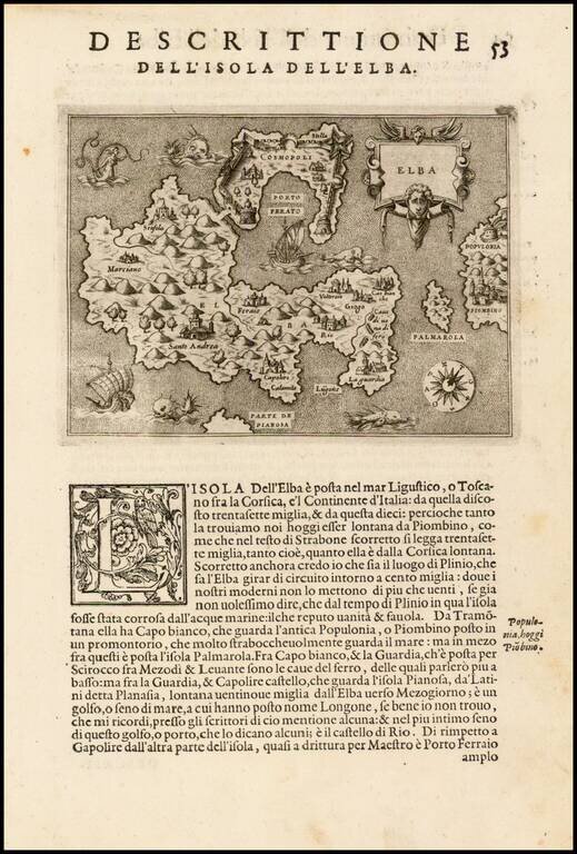
Fine early map of the Island of Elba and contiguous Tuscan Coastline, from Porcacchi's L'Isole Piu Famose Del Mondo… Finely engraved, with compass rose and decorative cartouche.