
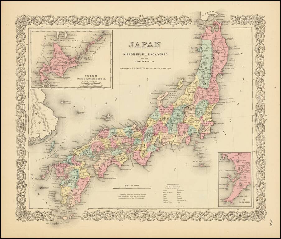
Detailed map of Japan, colored by Prefecture, with insets of Nagasaki and Yesso. Shows towns, rivers, lakes, mountains, islands, etc. A terrific regional map from J.H. Colton, one of the most prolific American mapmakers of the mid-19th century....
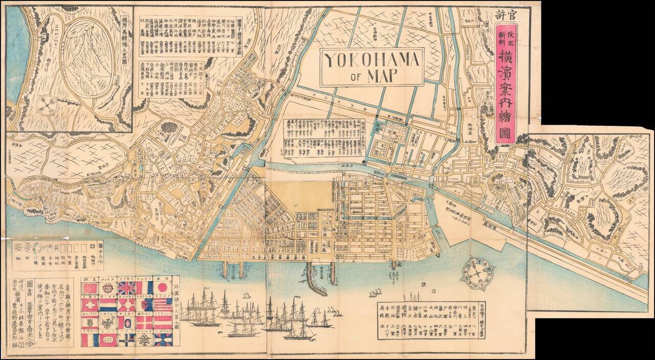
Wonderful Richly Illustrated Map of Yokohama, Featuring Flags of Foreign Nations and a Wonderful Malapropism "Yokohama of Map". Color woodblock map of the trading port of Yokohama, highlighting trade with foreign nations that flourished under the...
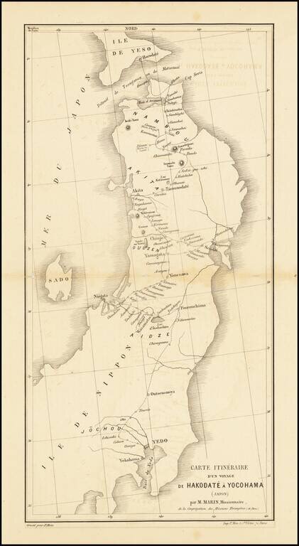
Scarce missionary map showing a portion of Japan, published in Paris. Includes the route taken by the Missionary Marin through Yokohama and Hokkaido.
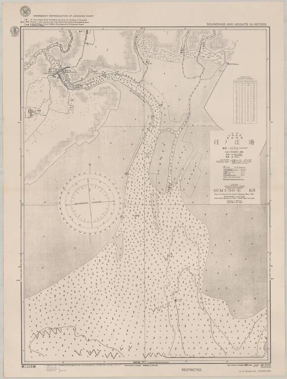
Scarce sea chart of part of the west coast of Kyushu, providing a fascinating insight into U.S. efforts to produce maps of Japan during World War II. The map, which was published by the Navy in September 1944, shows an area on the west coast of Kyushu,...
![(Second World War - Okinawa) [Large Battlefield Composite Map of Okinawa]](/map/small/63896.jpg)
6.5-Foot-Tall Battle-Used Map of Okinawa. Impressive battlefield composite map of Okinawa, composed of numerous sections of SECRET Army Map Service sheets cut and pasted together to form one large image. The map covers all of Okinawa, but for a small...
![(Second World War - Okinawa) [Battlefield Composite Map of Southern Okinawa]](/map/small/63897.jpg)
Battle-Used Map of Okinawa. Impressive battlefield composite map of Okinawa, composed of numerous sections of SECRET Army Map Service sheets cut and pasted together to form one large image. The map covers the southern most parts of Okinawa, including...
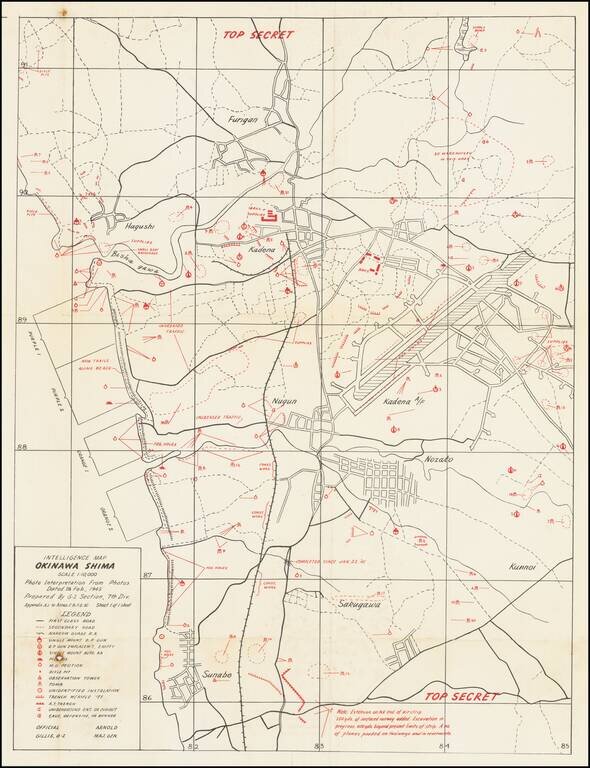
Top Secret American Map Used to Capture Kadena Airfield on Okinawa. Top Secret map of the Okinawa landing beaches Orange 1 & 2, and Purple 1 & 2, and the defenses between those beaches and Kadena airfield. The map was prepared based on...
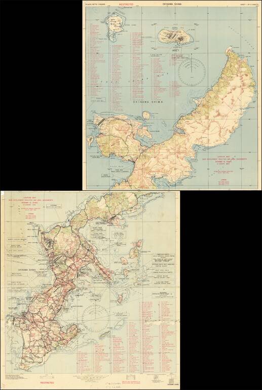
Restricted U.S. Military Map of Okinawa as it was Being Converted into a Major American Base. Color-printed map of Okinawa, produced by the 3020th Engr. Topo. Co. (Corps) on Okinawa, in September 1945, immediately after the end of World War II. The...
![(Commodore Perry) [Illustration of the Steam Locomotive.] [Jokisha no zu]](/map/small/55566.jpg)
The Miniature Steam Locomotive Commodore Perry Brought to Japan. Woodblock kawaraban print showing the miniature steam locomotive, which is one of the gifts to the Edo government Commodore Perry brought to Japan. The caption says "Gifts from Emperor...
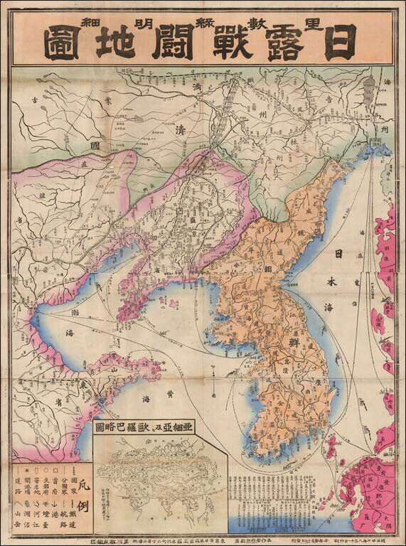
Fine large map of Korea and contiguous parts of China, published in 1904 or Meiji 37. The map was issued during the early days of the Russo-Japanese War (1904-1905), including the Japanese invasion of China and Korea, and the conflict that ensued with...
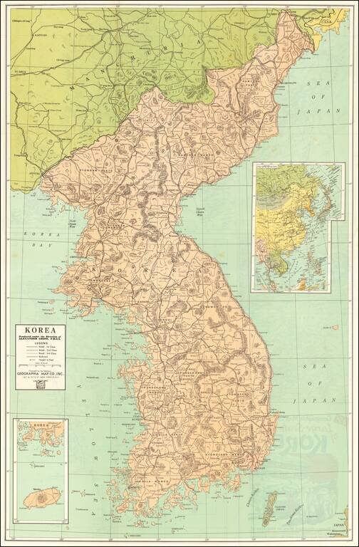
Vintage Korean War-Era map of the Korean Peninsula, published by Geographia Map Co. Inc., in New York City around 1950. The title panel on the verso of the map includes an image of an M46 Patton (?) and G.I.s in a Korean town. The verso includes a...
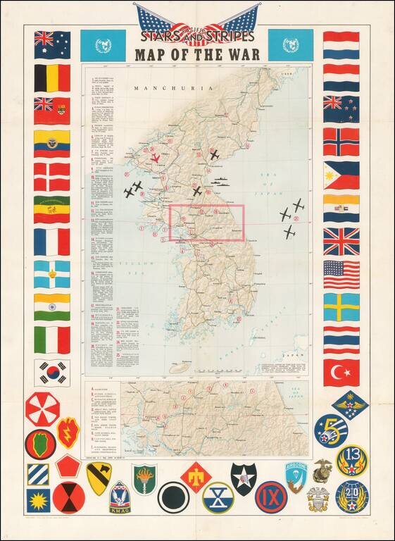
Decorative map of Korea, intended for distribution to soldiers stationed in Korea in the 1950s. Shaded relief with key military features locations marked and described. Includes a decorative border of flags of allies and insignia of military units.
The First Printed Map Based Upon the Projections of the Ancient Greek Geographer, Marinus of Tyre Nice example of Francesco Berlingheri's map Cyprus, the Holy Land and Middle East, from his Septe Giornate della Geographia di Francesco Berlinghieri...
![[Taprobana] Duodecima Asie Tabula](/map/small/58553.jpg)
Sri Lanka, As Known To The Greeks Fine old color example of this remarkable early map of Taprobana (Sri Lanka), from the 1486 Ulm edition of Ptolemy's Geographia. The map is drawn from the work of Nicolas Germanicus, whose manuscript maps were...
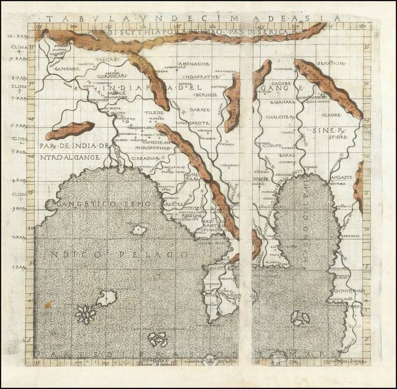
Martin Waldseemuller's Map of Southeast Asia, Based Upon Claudius Ptolemy Fine example of this important early map of the Indian Ocean and Southeast Asia, from the 1513 Waldseemuller edition of Ptolemy's Geography, Claudii Ptholomei Alexandrini. The...
![Tabula XII. Asiae [Title on verso] (Sri Lanka)](/map/small/55866.jpg)
Important early modern map of Taprobana, from Fries's 1525 edition of Geographia. This is an early woodblock map of the island of Taprobana, which depicts the typical misconceptions of Ptolemy showing the island greatly enlarged, surrounded by...