Map size in jpg-format: 2.17013MiB
Click to open in high resolution (open in new tab).
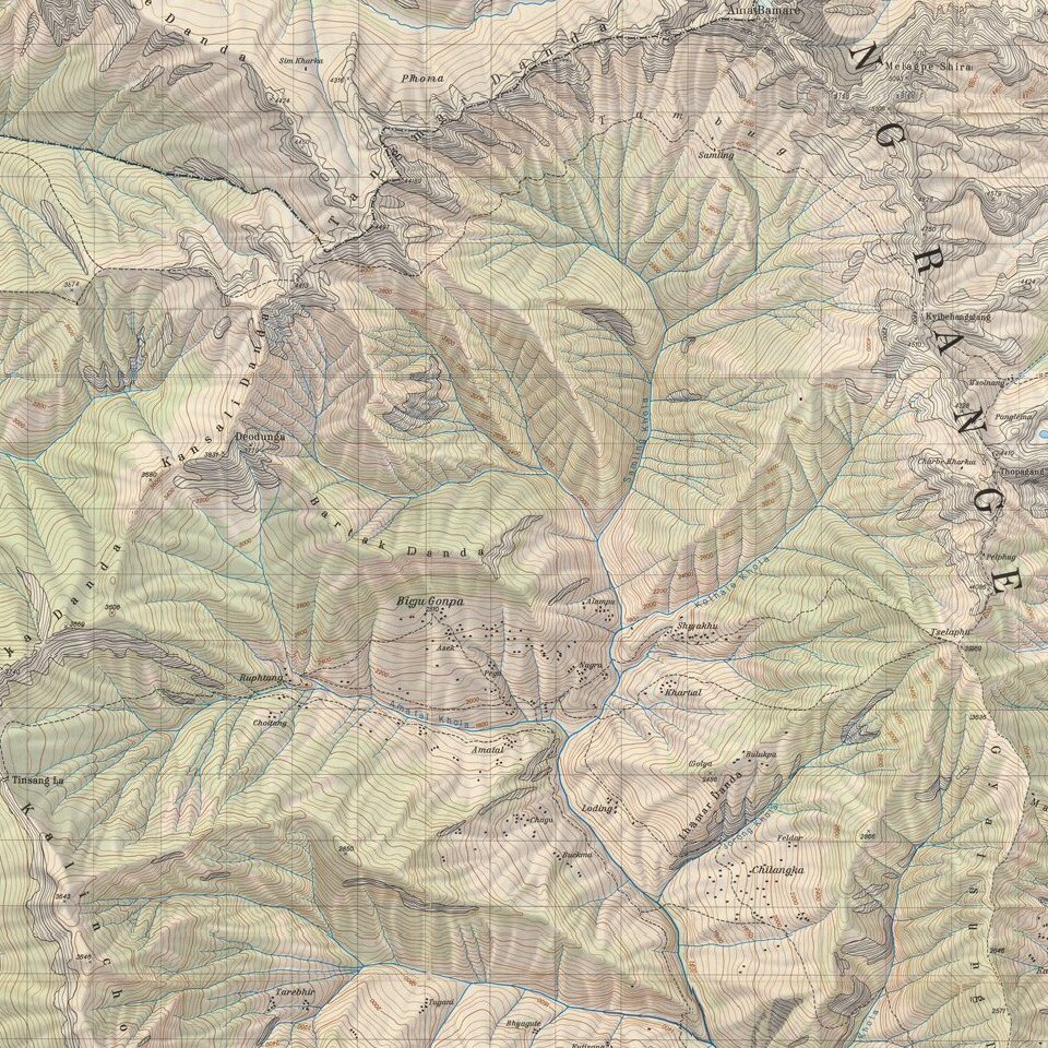
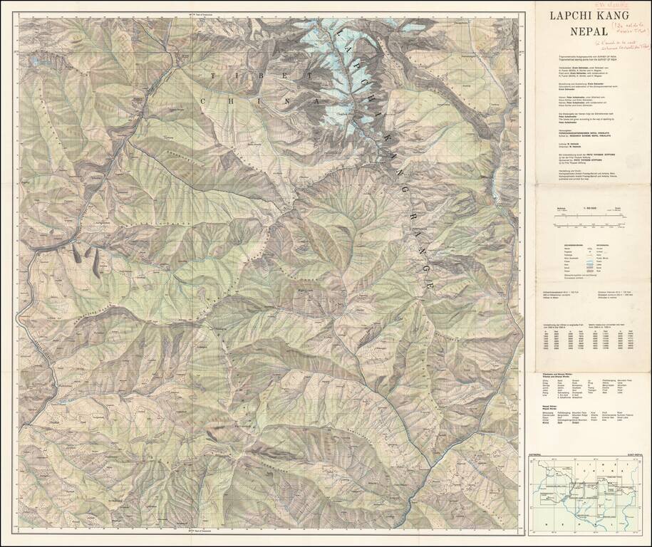
Scarce separately published map of Tibet and a section of Chinese Tibet.
The map credits Peter Aufschnaiter as one of its makers. Peter Aufschnaiter (1899 - 1973) was a Tyrolean mountaineer, agricultural scientist, geographer, and cartographer. His experiences with fellow climber Heinrich Harrer during World War II were depicted in the 1997 film Seven Years in Tibet.
In his early years he began climbing in the Kaiser mountain range and later, in Munich, Aufschnaiter became acquainted with several German alpinists of the time. He took part in expeditions to the Kangchenjunga (1929 and 1931) in Sikkim and had first contacts with Tibetans and learned the Tibetan language.
After several attempts at the Nanga Parbat, Aufschnaiter led a small four-man expedition in 1939, including Heinrich Harrer, to the Diamir Face with the aim of finding an easier route to the peak. Having concluded that the face was viable, they were in Karachi at the end of August waiting for a freighter to take them home. The ship being long overdue, Harrer, Ludwig and Lobenhoffer tried to reach Persia with their shaky car, but several hundred kilometers northwest of Karachi were put under the "protection" of British soldiers and escorted back to Karachi, where Aufschnaiter had stayed on.
Two days later war was declared and on 3 September 1939, all were put behind barbed wire to be transferred to a detention camp at Ahmednagar near Bombay two weeks later. They considered escaping to Portuguese Goa but when further transferred to Dehradun, where they were detained for years with 1,000 other enemy aliens, they found Tibet more promising. Their goal was the Japanese front in Burma or China.
Aufschnaiter and Harrer escaped and were re-captured a number of times before finally succeeding. On April 29, 1944, a group of seven men managed to escape from the camp. The group of escapees included Rolf Magener and Heins von Have (disguised as British officers) and Harrer, Aufschnaiter, the Salzburger Bruno Treipel (aka Treipl), and Berliner's Hans Kopp and Sattler (each disguised as Indian workers). Magener and von Have took a train to Calcutta and ultimately made their way to the Japanese army in Burma. The others made their way to the closest border. Sattler gave up on May 10, 1944. The other four men entered Tibet crossing the Tsang Chock-la Pass on May 17, 1944. Once they passed Tsang Chock-la Pass, the foursome split into two groups; Harrer and Kopp in one group and Aufschnaiter and Treipel in the other. Exhausted, Treipel gave up on June 17 and made his way back to the lowlands (via horseback). Several months later the remaining three gave up as they were still without visas for Tibet. Kopp headed towards Nepal but was ultimately captured by the British within a few days of arrival.
Aufschnaiter and Harrer, helped by the former's knowledge of the Tibetan language, proceeded to the capital of Lhasa which they reached on January 15,1946, having crossed Western Tibet (passing holy Mount Kailash), the South-West with Gyirong County and the Northern Changthang Plateau.
From then on Aufschnaiter played an important role in Tibet. Employed by the government he helped plan a hydroelectric power plant and a sewage system for Lhasa and started first attempts at river regulations and reforestation in the area. He also looked into improving the quality of seeds. With Harrer he charted the first exact map of the capital city. His archaeological findings led to a correspondence with the scholar Giuseppe Tucci. His extensive work is described in Heinrich Harrer's Seven Years in Tibet and Harrer's autobiography Beyond Seven Years in Tibet: my life before, during and after. Aufschnaiter's own book Eight Years in Tibet includes many of his own photographs and sketches.
In October 1950, the advance of the Chinese People's Liberation Army to Lhasa forced Aufschnaiter and Harrer to join the caravan of the Dalai Lama when he retreated to the Chumbi Valley bordering Sikkim and India. Harrer proceeded to India, but Aufschnaiter stayed at Gyantse and left Tibet only 10 months later.
He arrived in Nepal in 1952 where he worked as a cartographer and then in New Delhi, for the Indian Army. He eventually obtained a Nepalese passport which allowed him access to many restricted remote areas and he discovered valuable early Buddhist frescos. Aufschnaiter spent most of his remaining years in Nepal, working as an agricultural engineer. At first he worked for Swiss Technical Aid. From 1956 on he held a position as an agriculture expert for the United Nations Food and Agriculture Organization.
If you are a student, write to us in telegram: @antiquemaps and indicate what material you need and for what work you need a map in high detail. We are ready to provide material on special terms. For students only!
![[Martin Behaim Globe / Book] Pars Globi terrestris Ao. 1492 a Martino Behaim Equite Lusitano Norimbergae confecti Delineavit Christoph. Theoph de Murr 1778 (bound with:) Diplomatische Geschichte des Portugesischen berühmten Ritters Martin Behaims](/map/small/68828.jpg)
![Il Disegno Della Terza Parte Dell' Asia [Gastaldi's Wall Map of SE Asia with extra panels!]](/map/small/30554hbp.jpg)
![Chinae, olim Sinarum regionis nova descriptio. auctore Ludouico Georgio. [English Edition!]](/map/small/71123.jpg)