
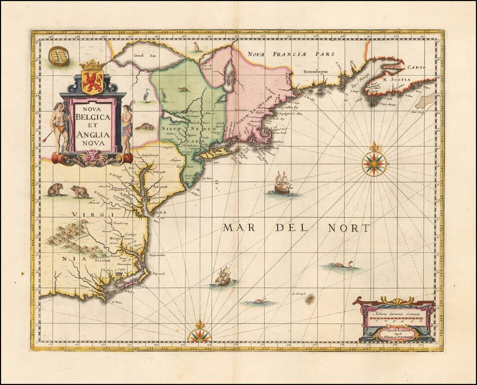
Valk & Schenk's edition of Jansson's highly influential map of the East Coast of North America, from the Carolinas to Nova Scotia. Jansson based his map upon Johannes De Laet's map of 1630 (created and engraved by Hessel Gerritsz of the Dutch East...
![[British Colonies in North America] Carte Qui Contient Une Description Des Iles & Terres Que Les Anglois . . .[Chesapeake, Carolinas, New England, Bermuda, Gulf Coast, Jamaica, Barbadoes & Canada]](/map/small/46200.jpg)
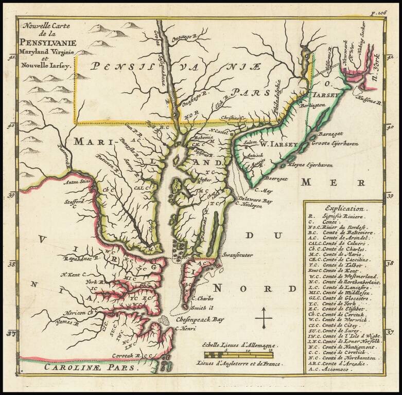
Highly sought after group of maps from Chatelain's 7 Volume Atlas Historique. Includes 8 maps, each of which would be highly coveted as a separate map. The maps include 1) a map of the Carolinas, 2) a map of the Chesapeake, 3) Canada and New England,...
![A Chart of the Atlantick Ocean from Buttons Island To Port Royall [Includes Large Map of Chesapeake Bay, Delaware Bay, New York City and Vicinity]](/map/small/23075.jpg)
Rare and Fine Chart of the Eastern Seaboard from an Influential Atlas Scarce early-eighteenth century English sea chart of the East Coast of North America, which includes a second and more detailed chart of the region between Cape Henry and Long...
![Dominia Anglorum in America Septentrionali Specialibus Mappis Londini primum a Mollio… [4 maps--New England; Chesapeake, Georgia, Carolinas & Florida; and Nova Scotia…]](/map/small/53909.jpg)
In the mid 18th Century, the Homann Heirs issued this group of four maps on a single sheet, which are based upon earlier maps by Herman Moll, published in London. Each of the maps was separately issued in Moll's Atlas Minor. The map titles are New...
![Various Plans and Draughts of Cities, Towns, Harbours &c . . . [New York, Boston, Charleston, Delaware River to Philadelphia & Havana]](/map/small/58898.jpg)
Detailed set of Revolutionary War era harbor plans, based upon larger maps of the period, including New York, Boston, Charleston and Philadelphia. Each of the plans in turn is based upon separately issued large format plans by Faden.
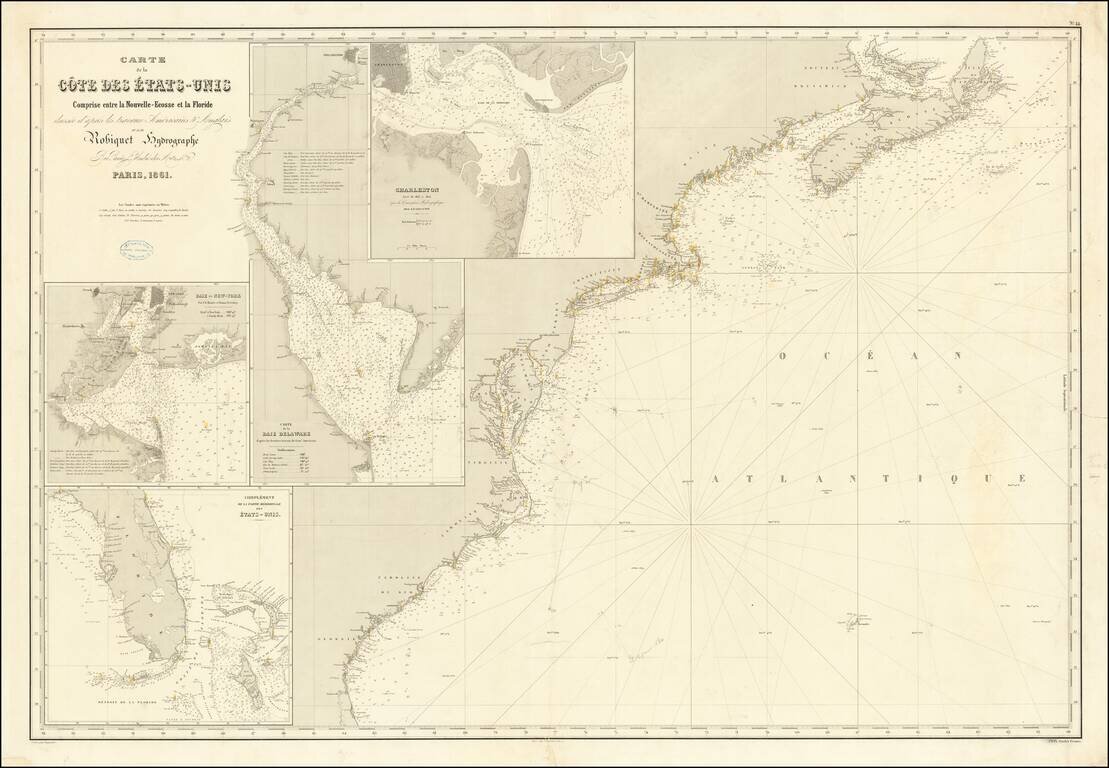
Rare separately published French chart of the region from Nova Scotia to Florida, with large inset maps of Florida, New York Harbor, Charleston and the Delaware Bay. The map was apparently used either for contemporary navigation or a survey off the...
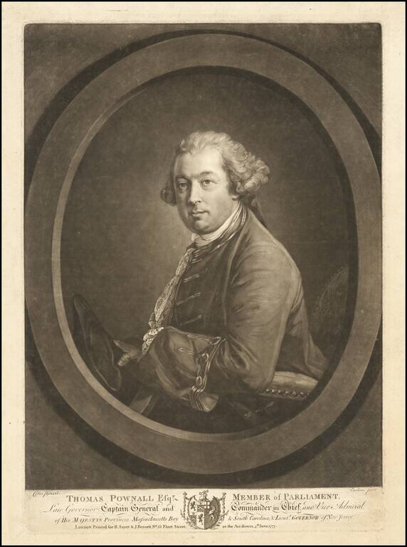
Rare mezzotint portrait of Thomas Pownall, one of the most important figures in the later Colonial history of the British Colonies in North America. Mezzotint portrait engraved by Richard Earlom after a painting by Francis Cotes. Thomas Pownall was...

Detailed map of the Ohio Valley and regions to the East Nice example of Robert de Vaugondy's map of the Northern British Colonies, French interests to the North of the Great Lakes, and contested "Back Settlements," including a fine detailed treatment...

A Rare British Sea Chart of the Southeast and Mid-Atlantic Regions (The Colonial Williamsburg / William Wooldridge Copy) Extremely rare separately issued chart of the coast from New York to North Carolina, which was issued separately and in Laurie...
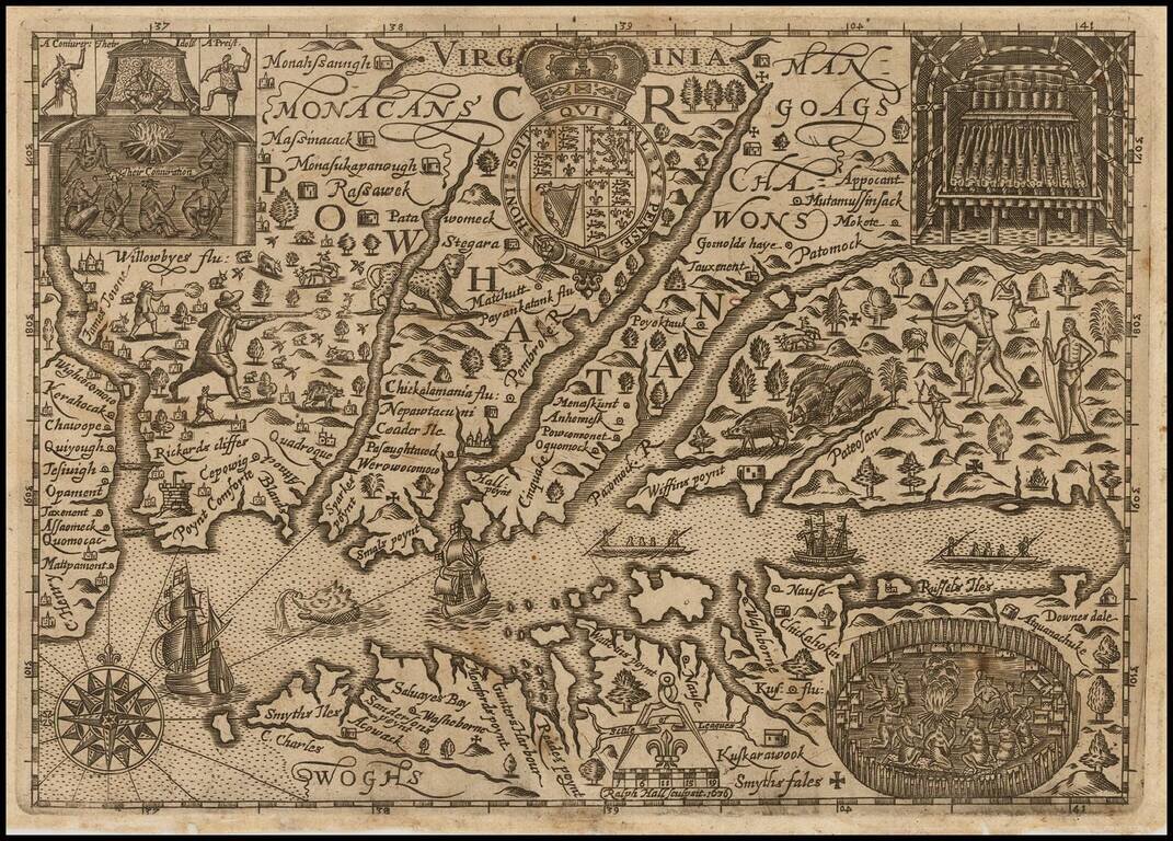
Early English Colonial Map of Virginia Rare map of Virginia, engraved by Ralph Hall, for Wye Saltonstall's Historia Mundi. This remarkable map of Virginia is based in part upon John Smith's map of Virginia, embellished with a lively and unique...

The First Dutch Map of Virginia Fine, wide-margined, old color example of Blaeu's map of Virginia, and the Chesapeake region, based upon John Smith's map of Virginia, the most important map of Virginia published in the 17th Century. This is the...

A highly decorative and important sea chart showing Florida, the Gulf Coast, Caribbean, Central America and the region from south of the mouth of the Delaware River. This fine separately published map was first engraved around 1650, but is based...
![A New Map of Virginia [and the Chesapeake]](/map/small/48950.jpg)
First State of Morden's Map of Virginia. Fine example of Robert Morden's map of Virginia, one of the earliest obtainable English maps of the Chesapeake region. Beginning in the 1670s, the English fortunes in North America took a dramatic turn...
Early map of the region from New York City to Cape Henry, centered on the Cheaspeake and Delaware, from Abraham Wolfgang's L'Amerique Angloise, ou Description des Isles et Terres dur Roi Angleterre, dans L'Amerique, published in Amsterdam in 1688. The...

Christopher Browne's Map of the Chesapeake & Delaware Bay Regions -- The First Map to Accurately Depict The Boundary Line Which Settled The Penn-Calvert Boundary Dispute, Which Would Become The Mason-Dixon Line Rare second state of Christopher...
![Carte Particuliere de Virginie, Maryland, Pennsilvanie, La Nouvelle Jarsey. Orient et Occidentale [Heighten in Gold!]](/map/small/61392mp2.jpg)
Heightened with Gold Leaf -- Fine Old Color Fine early large-format chart of Chesapeake Bay and the Delaware Estuary, by Pierre Mortier. This detailed and attractive chart focuses on Chesapeake Bay, and includes all of the Tidewater areas of...